Washington Metro
|
| |||
| Overview | |||
|---|---|---|---|
| Locale | Washington, D.C. | ||
| Transit type | Rapid transit | ||
| Number of lines | 6 | ||
| Line number |
| ||
| Number of stations | 91 (4 more under construction and 3 more planned) | ||
| Daily ridership | 868,400 (Q2 2016)[1] | ||
| Annual ridership | 261,435,200 (2015)[2] | ||
| Chief executive | Paul Wiedefeld[3] | ||
| Headquarters |
600 5th St NW Washington, D.C. 20001 | ||
| Website | www.wmata.com | ||
| Operation | |||
| Began operation | March 27, 1976 | ||
| Operator(s) | Washington Metropolitan Area Transit Authority (WMATA) | ||
| Character | At-grade, elevated, and underground | ||
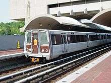
| Number of vehicles | 1,126 railcars | ||
| Train length | 6 or 8 cars | ||
| Headway | 6 mins peak; 12–20 mins offpeak | ||
| Technical | |||
| System length | 117 mi (188 km) | ||
| No. of tracks | 2 | ||
| Track gauge | 4 ft 8 1⁄4 in (1,429 mm)[4] | ||
| Minimum radius of curvature | 225 feet (68.6 m)[4] | ||
| Electrification | Third rail 750 V DC | ||
| |||
The Washington Metro, known colloquially as Metro and branded Metrorail,[5] is the rapid transit system serving the Washington, D.C. metropolitan area in the United States. It is administered by the Washington Metropolitan Area Transit Authority (WMATA), which also operates Metrobus service under the Metro name.[6] Besides the District, Metro serves several jurisdictions in Maryland and Virginia. In Maryland, Metro provides service to Montgomery and Prince George's counties; in Virginia, to Arlington and Fairfax counties and the independent city of Alexandria. Combined with its ridership in the independent Virginia cities of Falls Church and Fairfax, the Metro service area is largely coextensive with the inner ring of the Washington metropolitan area. The system is currently being expanded into Loudoun County, Virginia. It operates mostly as a subway in the District itself, while most of the suburban tracks are at surface level or elevated.
Opened in 1976, the network now includes six lines, 91 stations, and 117 miles (188 km) of route.[7][8]
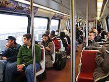
Metro is the second-busiest rapid transit system in the United States in number of passenger trips, after the New York City Subway.[9] There were 215.3 million trips, or 712,843 trips per weekday, on Metro in fiscal year 2015.[10] In June 2008, Metro set a monthly ridership record with 19,729,641 trips, or 798,456 per weekday.[11] Fares vary based on the distance traveled, the time of day, and the type of card used by the passenger. Riders enter and exit the system using a proximity card called SmarTrip. Metro also has the distinction of having the longest, single-tier escalator in the Western Hemisphere in the Wheaton station (230 feet long).[12]
History
During the 1960s plans were laid for a massive freeway system in Washington. Harland Bartholomew, who chaired the National Capital Planning Commission, thought that a rail transit system would never be self-sufficient because of low density land uses and general transit ridership decline.[13] But the plan met fierce opposition, and was altered to include a Capital Beltway system plus rail line radials. The Beltway received full funding; funding for the ambitious Inner Loop Freeway system was partially reallocated toward construction of the Metro system.[14]
In 1960 the federal government created the National Capital Transportation Agency to develop a rapid rail system. In 1966, a bill creating WMATA was passed by the federal government, the District of Columbia, Virginia, and Maryland,[15] with planning power for the system being transferred to it from the NCTA.[16]
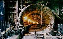
WMATA approved plans for a 98-mile (158 km) regional system in 1968.[16] Construction began after a groundbreaking ceremony on December 9, 1969, when Secretary of Transportation John A. Volpe, District Mayor Walter Washington, and Maryland Governor Marvin Mandel tossed the first spade of dirt at Judiciary Square.[17] The first portion of the system opened March 27, 1976, with 4.6 miles (7.4 km) available on the Red Line with five stations from Rhode Island Avenue to Farragut North, all in the District of Columbia.[18] Arlington County, Virginia was linked to the system on July 1, 1977;[19] Montgomery County, Maryland, on February 6, 1978;[20] Prince George's County, Maryland, on November 20, 1978;[21] and Fairfax County, Virginia, and Alexandria, Virginia, on December 17, 1983.[15][22] Underground stations were built with cathedral-like arches of concrete, highlighted by soft, indirect lighting.[23] The name Metro was suggested by Massimo Vignelli, who designed the subway maps for the New York City Subway.[24]
The 103-mile (166 km), 83-station system was completed with the opening of the Green Line segment to Branch Avenue on January 13, 2001. This did not mean the end of the growth of the system: a 3.22-mile (5.18 km) extension of the Blue Line to Largo Town Center and Morgan Boulevard opened on December 18, 2004. The first in-fill station, NoMa – Gallaudet University (at the time called the New York Ave–Florida Ave–Gallaudet University station) on the Red Line between Union Station and Rhode Island Ave-Brentwood, opened November 20, 2004. Construction began in March 2009 for an extension to Dulles Airport to be built in two phases and opening in 2014 and 2018.[25] The first phase, five stations connecting East Falls Church to Tysons Corner and Wiehle Avenue in Reston, opened on July 26, 2014.[26]
Metro construction required billions of federal dollars, originally provided by Congress under the authority of the National Capital Transportation Act of 1969 (Public Law 91-143). The cost was paid with 67% federal money and 33% local money. This act was amended on January 3, 1980 by Public Law 96-184, "The National Capital Transportation Amendment of 1979" (also known as the Stark-Harris Act), which authorized additional funding of $1.7 billion to permit the completion of 89.5 miles (144.0 km) of the system as provided under the terms of a full funding grant agreement executed with WMATA in July 1986, which required 20% to be paid from local funds. On November 15, 1990, Public Law 101-551, "The National Capital Transportation Amendments of 1990", authorized an additional $1.3 billion in federal funds for construction of the remaining 13.5 miles (21.7 km) of the 103-mile (166 km) system, completed via the execution of full funding grant agreements, with a 63% federal/37% local matching.[27]
The highest ridership for a single day was on the day of the inauguration of Barack Obama, January 20, 2009, with 1,120,000 riders. It broke the previous record, set the day before, of 866,681 riders.[28] June 2008 set several ridership records: the single-month ridership record of 19,729,641 total riders, the record for highest average weekday ridership with 1,044,400 weekday trips, had five of the ten highest ridership days, and had 12 weekdays in which ridership exceed 800,000 trips.[11]
In February 2006 Metro officials chose Randi Miller, a car dealership employee from Woodbridge, Virginia, to record new "doors opening", "doors closing", and "please stand clear of the doors, thank you" announcements after winning an open contest to replace the messages recorded by Sandy Carroll in 1996. The "Doors Closing" contest attracted 1,259 contestants from across the country.[29]
On October 30, 2010, the crowd at the Rally to Restore Sanity and/or Fear broke a 19-year record in Saturday ridership, with 825,437 trips. The previous record had been set on June 8, 1991 at 786,358 trips during the Desert Storm rally.[30][31]
Opening dates
| Year | Line | From | To |
|---|---|---|---|
| March 27, 1976 | Red | Farragut North | Rhode Island Avenue |
| December 15, 1976 | Red (opening of Gallery Place) | Farragut North | Rhode Island Avenue |
| January 17, 1977 | Red | Dupont Circle | Rhode Island Avenue |
| July 1, 1977 | Blue | National Airport | Stadium-Armory |
| February 6, 1978 | Red | Dupont Circle | Silver Spring |
| November 20, 1978 | Orange/Blue | National Airport | New Carrollton |
| December 1, 1979 | Orange | Ballston | New Carrollton |
| November 22, 1980 | Blue/Orange | National Airport/Ballston | Addison Road/New Carrolton |
| December 5, 1981 | Red | Van Ness-UDC | Silver Spring |
| April 30, 1983 | Yellow | National Airport | Gallery Place |
| December 17, 1983 | Yellow | Huntington | Gallery Place |
| August 25, 1984 | Red | Grosvenor | Silver Spring |
| December 15, 1984 | Red | Shady Grove | Silver Spring |
| June 7, 1986 | Orange | Vienna | New Carrollton |
| September 22, 1990 | Red | Shady Grove | Wheaton |
| May 11, 1991 | Yellow | Huntington | U Street-Cardozo |
| June 15, 1991 | Blue | Van Dorn Street | Addison Road |
| December 28, 1991 | Green | U Street-Cardozo | Anacostia |
| December 11, 1993 | Green | Fort Totten | Greenbelt |
| June 29, 1997 | Blue | Franconia-Springfield | Addison Road |
| July 25, 1998 | Red | Shady Grove | Glenmont |
| September 18, 1999 | Green (connecting previous two segments) | Greenbelt | Anacostia |
| January 13, 2001 | Green | Greenbelt | Branch Avenue |
| November 20, 2004 | Red (addition of New York Ave Station) | Shady Grove | Glenmont |
| December 18, 2004 | Blue | Franconia-Springfield | Largo Town Center |
| July 26, 2014 | Silver | Wiehle – Reston East | Largo Town Center |
| TBA 2019 or 2020 | Silver | Ashburn | Largo Town Center |
Architecture
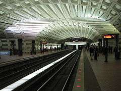
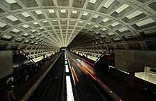
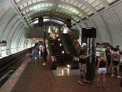
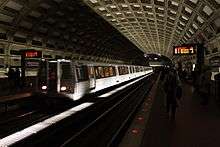
Many Metro stations were designed by Chicago architect Harry Weese and are examples of late-20th century modern architecture. With their heavy use of exposed concrete and repetitive design motifs, Metro stations display aspects of brutalist design. The stations also reflect the influence of Washington's neoclassical architecture in their overarching coffered ceiling vaults. Weese worked with Cambridge, Massachusetts-based lighting designer Bill Lam for the indirect lighting used throughout the system.[33][34] All of Metro's original Brutalist stations are found in Downtown Washington, D.C. and neighboring urban corridors of Arlington, Virginia, with newer stations incorporating simplified cost-efficient designs.[35]
In 2007 the design of the Metro's vaulted-ceiling stations was voted number 106 on the "America's Favorite Architecture" list compiled by the American Institute of Architects (AIA), and was the only brutalist design to win a place among the 150 selected by this public survey.
In January 2014 the AIA announced that it would present its Twenty-five Year Award to the Washington Metro system for "an architectural design of enduring significance" that "has stood the test of time by embodying architectural excellence for 25 to 35 years". The announcement cited the key role of Weese, who conceived and implemented a "common design kit-of-parts", which continues to guide the construction of new Metro stations over a quarter-century later, albeit with designs modified slightly for cost reasons.[36]
-
Intersection of coffered concrete ceiling vaults at Metro Center (opened 1976), a major transfer station
-
A train departs from McPherson Square station (opened 1977), which has an original ceiling vault design
-
.JPG)
Canopy over entrance to L'Enfant Plaza (opened 1977) echoes the arched ceiling underground
-
Woodley Park station (opened 1981) shows a modified ceiling vault
-
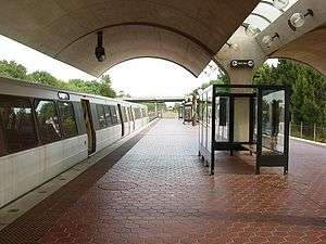
Shady Grove (opened 1984) is a typical original above-ground station
-
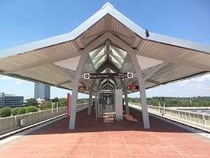
Spring Hill (opened 2014) is a typical newer above-ground station
System
.svg.png)
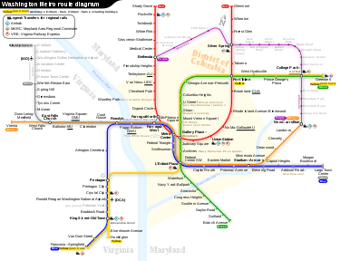
Since opening in 1976, the Metro network has grown to include six lines, 91 stations, and 118 miles (190 km) of route.[37] The rail network is designed according to a spoke-hub distribution paradigm, with rail lines running between downtown Washington and its nearby suburbs. The system makes extensive use of interlining – running more than one service on the same track. There are six operating lines.[37][38] The system's iconic official map was designed by noted graphic designer Lance Wyman[39] and Bill Cannan while they were partners in the design firm of Wyman & Cannan in New York City.[40]
About 50 miles (80 km) of Metro's track is underground, as are 47 of the 91 stations. Track runs underground mostly within the District and high-density suburbs. Surface track accounts for about 46 miles (74 km) of the total, and aerial track makes up 9 miles (14 km).[37]
In an effort to gain revenues, WMATA has started to allow retail ventures in Metro stations. WMATA has authorized DVD-rental vending machines and ticket booths for the Old Town Trolley Tours and is seeking additional retail tenants.[41]
| Line Name | Opened | Stations | Distance | Termini | ||
|---|---|---|---|---|---|---|
| mi | km | Western/Southern | Eastern/Northern | |||
| 1976 | 27 | 31.9 | 51.3 | Shady Grove | Glenmont | |
| 1977 | 27 | 30.3 | 48.8 | Franconia–Springfield | Largo Town Center | |
| 1978 | 26 | 26.4 | 42.5 | Vienna | New Carrollton | |
| 1983 | 17 | 15.07 | 24.25 | Huntington Franconia–Springfield (Rush+) |
Mount Vernon Square (rush hours) Greenbelt (Rush+) Fort Totten (other times) | |
| 1991 | 21 | 23.04 | 37.08 | Branch Avenue | Greenbelt | |
| 2014 | 28 | 29.6 | 47.6 | Wiehle–Reston East Ashburn (opens 2019) |
Largo Town Center | |
Financing
Metro relies extensively on passenger fares and appropriated financing from the Maryland, Virginia, and Washington DC governments, which are represented on Metro's board of directors. The system does not have a dedicated revenue stream as other city's mass transit systems do. Critics allege that this has contributed to Metro's recent history of maintenance and safety problems.[42]
For Fiscal Year 2015, the estimated farebox recovery ratio (fare revenue divided by operating expenses) was 66 percent, based on the WMATA approved budget.[43]
Infrastructure
Stations
There are 40 stations in the District of Columbia, 15 in Prince George's County, 11 in Montgomery County, 11 in Arlington County, 11 in Fairfax County, and three in the City of Alexandria.[37] The second phase of the Silver Line will add 6 new stations—three more in Fairfax County and three in Loudoun County, Virginia—in 2019 or 2020.[44]
At 196 feet (60 m) below the surface, the Forest Glen station on the Red Line is the deepest in the system. There are no escalators; high-speed elevators take 20 seconds to travel from the street to the station platform. The Wheaton station, next to Forest Glen station on the Red Line, has the longest, continuous escalator in the USA and in the Western Hemisphere, at 230 feet (70 m).[37][45] The Rosslyn station is the deepest station on the Orange/Blue Line, at 117 feet (36 m) below street level. The station features the second-longest continuous escalator in the Metro system at 194 feet (59 m); an escalator ride between the street level and the mezzanine level takes nearly two minutes.[46]
The system is not centered on any single station, but Metro Center is at the intersection of the Red, Orange, Blue, and Silver Lines.[47] The station is also the location of WMATA's main sales office. Metro has designated five other "core stations" that have high passenger volume, including:[48] Gallery Place, transfer station for the Red, Green and Yellow Lines; L'Enfant Plaza, transfer station for the Orange, Blue, Silver, Green and Yellow Lines; Union Station, the busiest station by passenger boardings;[47] Farragut North; and Farragut West.
In order to deal with the high number of passengers in transfer stations, Metro is studying the possibility of building pedestrian connections between nearby core transfer stations. For example, a 750-foot (230 m) passage between Metro Center and Gallery Place stations would allow passengers to transfer between the Orange/Blue/Silver and Yellow/Green Lines without going one stop on the Red Line. Another tunnel between Farragut West and Farragut North stations would allow transfers between the Red and Orange/Blue/Silver lines, decreasing transfer demand at Metro Center by an estimated 11%.[48] The Farragut pedestrian tunnel has yet to be physically implemented, but was added in virtual form effective October 28, 2011. The SmarTrip system now interprets an exit from one Farragut station and entrance to the other as part of a single trip, allowing card holders to transfer on foot without having to pay a second full fare.[49]
Rolling stock
Metro’s fleet consists of 1,126 rail cars, each 75 feet (22.86 m) long.[50] Trains have a maximum speed of 75 mph (121 km/h), and average 33 mph (53 km/h), including stops. Operating rules presently limit their top speed to 59 mph (95 km/h).[37] All cars operate as married pairs (consecutively numbered even-odd), with systems shared across the pair.[51] Metro currently operates 850 cars during rush hours. There are 814 cars in active service, four cars have been permanently removed from revenue service for use as the "money train", and the remaining 36 cars compose gap trains to serve as backup should a train experience problems.[52]
Metro's rolling stock was acquired in six phases, and each version of car is identified with a separate series number. The original order of 300 rail cars (290 of which are in operation as of June 2009[53]) was manufactured by Rohr Industries, with final delivery in 1978. These cars are numbered 1000–1299 and were rehabilitated in the mid-1990s. Breda Costruzioni Ferroviarie (Breda), now AnsaldoBreda, manufactured the second order of 76 cars delivered in 1983 and 1984. These cars, numbered 2000–2075, were rehabilitated in the early 2000s by Alstom in Hornell, New York. A third order of 288 cars, also from Breda, were delivered between 1984 and 1988. These cars are numbered 3000–3291 and were rehabilitated by Alstom in the early 2000s. An order of 100 cars from Breda, numbered 4000–4099, were delivered between 1992 and 1994. A fifth order of 192 cars was manufactured by Construcciones y Auxiliar de Ferrocarriles (CAF) of Spain. These cars are numbered 5000–5191 and were delivered from 2001 through 2004. A sixth order of 184 cars from Alstom Transportation, are numbered 6000-6183 and were delivered between 2005 and 2007. The cars have body shells built in Barcelona, Spain with assembly completed in Hornell, New York.[54]
The 7000 series of cars, currently being built by Kawasaki Heavy Industries Rolling Stock Company of Kobe, Japan are being delivered for on-site testing during winter 2013, and first entered service April 14, 2015 on the Blue Line. The new cars are different from previous models in that while still operating as married pairs, the cab in one car was eliminated, turning it into a B car. The new design allows for increased passenger capacity, elimination of redundant equipment, greater energy efficiency, and lower maintenance costs. Metro plans to eventually purchase up to 748 cars to increase system capacity and replace its older rolling stock.[50][55] The National Transportation Safety Board investigation of the fatal June 22, 2009, accident led it to conclude that the 1000 series cars are unsafe and unable to protect customers in a crash.
As a result, on July 26, 2010, Metro voted to purchase 300 7000 series cars to replace the remaining 1000 series cars.[56][57] An additional 128 7000 series cars were also ordered to serve the new Silver Line to Dulles Airport (64 for each phase). In May 2013, Metro placed another order for 100 7000 series cars, which will replace all of the 4000 series cars.[58] By June 2015 WMATA plans to exercise their remaining options to purchase an additional 220 7000 series railcars for fleet expansion, bringing the total number of 7000 series railcars on order to 748.[59]
In May 2015 WMATA's plan to replace 192 of the chronically problematic 5000-series cars built in the early 2000s with 220 new 7000-series cars was at risk because the older cars were funded by federal money and requires FTA approval.[60]
Signaling and operation
During normal passenger operation on revenue tracks, trains are designed to be controlled by an integrated Automatic Train Operation (ATO) and Automatic Train Control (ATC) system that accelerates and brakes trains automatically without operator intervention. All trains are still manned with train operators who open and close the doors, make station announcements, and supervise their trains. The system was designed so that an operator could manually operate a train when necessary.[61]
Since June 2009, when two Red Line trains collided and killed nine people due in part to malfunctions in the ATC system, all Metro trains have been manually operated.[62] The current state of manual operation has led to heavily degraded service, with new manual requirements such as absolute blocks, speed restrictions, and end-of-platform stopping leading to increased headways between trains, increased dwell time, and worse on-time performance.[63] Metro will begin phasing back in ATC in October 2014.[64]
The train doors were originally designed to be opened and closed automatically and the doors would re-open if an object blocked them, much as elevator doors do. Almost immediately after the system opened in 1976 Metro realized these features were not conducive to safe or efficient operation and they were disabled. At present the doors may be opened automatically or manually. If a door tries to close and it meets an obstruction, the operator must re-open the door.
Hours and headways
Metrorail begins service at 5 am Monday through Friday and at 7 am Saturdays and Sundays; it ends service at midnight seven nights a week, although the last trains leave the end stations inbound about half an hour before these times.[65] Trains run more frequently during rush hours on all lines, with scheduled peak hour headways of 3 minutes on the Red Line and 6 minutes on all other lines. Headways are much longer during midday and evening on weekdays and all weekend. The midday six-minute headways are based on a combination of two Metrorail lines (Orange/Blue and Yellow/Green) as each route can run every 12 minutes; in the case of the Red Line, every other train bound for Glenmont terminates at Silver Spring instead. Night and weekend service varies between 8 and 24 minutes, with trains generally scheduled only every 20 minutes. As of 2012, the WMATA board of directors was considering adopting a new policy that would codify maximum acceptable headways as 15 minutes during peak hours and 30 minutes during off-peak.[66]
Other service truncations also occur in the system during rush hour service only. On the Red Line, every other train bound for Shady Grove terminates at Grosvenor-Strathmore, in addition to the alternating terminations at Silver Spring mentioned above. For the Yellow Line, all non-Rush+ trains (that is, all trains originating from Huntington, not Franconia-Springfield) bound for Fort Totten terminate at Mount Vernon Square. These are primarily instituted due to a limited supply of rail cars and the locations of pocket tracks throughout the system.
Until 1999, Metro ended service at midnight every night, and weekend service began at 8 am. That year, WMATA began late night service on Fridays and Saturdays until 1 am. By 2007, with encouragement from businesses, that closing time had been pushed back to 3 am.[67] There were plans floated to end late night service due to costs in 2011, but they were met with resistance by riders.[68] WMATA temporarily discontinued late night rail service on May 30, 2016, so that Metro can conduct an extensive track rehabilitation program in an effort to improve the system's reliability.[69] Metro is proposing to permanently end late night service and close at 10pm on Sunday, and at midnight Monday through Saturday.[70]
Special service patterns
Metro runs special service patterns on holidays and when events in Washington may require additional service. Independence Day activities require Metro to adjust service to provide extra capacity to and from the National Mall.[71] WMATA makes similar adjustments during other events, such as presidential inaugurations. Metro has altered service and used some stations as entrances or exits only to help manage congestion.[72]
Rush Plus
In 2012 WMATA announced enhanced rush period service that was implemented on June 18, 2012, under the name Rush+ (or Rush Plus). Rush Plus service occurs only during portions of peak service: 6:30-9 AM and 3:30-6 PM, Monday through Friday.
The Rush+ realignment was intended to free up space in the Rosslyn Portal (the tunnel between Rosslyn and Foggy Bottom), which operates at full capacity already. When Silver Line service began, those trains would be routed through the tunnel, and so some of what were Blue Line trains to Largo Town Center were now diverted across the Fenwick Bridge to become Yellow Line trains running all the way up the Green Line to Greenbelt. Select Yellow Line trains running south diverted along the Blue Line to Franconia-Springfield (as opposed to the normal Yellow line terminus at Huntington). Until the start of Silver Line service, excess Rosslyn Tunnel capacity was used by additional Orange Line trains that traveled along the Blue Line to Largo (as opposed to the normal Orange Line terminus at New Carrollton). Rush+ had the additional effect of giving some further number of passengers transfer-free journeys, though severely increasing headways for the portion of the Blue Line running between Pentagon and Rosslyn.
Passenger information systems
A Passenger Information Display System (PIDS) was installed in all Metrorail stations in 2000. Displays are located on all track platforms and at the mezzanine entrances of stations, and provide real-time information on next train arrivals, delayed trains, emergency announcements, and related information.[73] WMATA also provides current train and related information to customers with conventional web browsers, as well as users of smartphones and other mobile devices.[74] In 2010 Metro began sharing its PIDS data with outside software developers, for use in creating additional real-time applications for mobile devices. Free apps are available to the public on major mobile device software platforms (iPhone/iPad, Android, Windows Phone, Palm).[75][76] WMATA also began providing real-time train information by phone in 2010.[77]
Fare structure
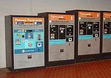
Riders enter and exit the system using a stored-value card in the form of a proximity card known as SmarTrip. The fare is deducted from the balance of the card when exiting.[78] Farecards are purchased primarily at vending machines in each station. SmarTrip cards can be purchased at station vending machines, online or at retail outlets, and can store up to $300 in value.
Metro fares vary based on the distance traveled and the time of day at entry. During peak hours (weekdays from opening until 9:30 a.m. and 3–7 p.m.), fares (effective 2014) range from $2.15 to $5.90, depending on distance traveled. At all other times, fares range from $1.75 to $3.60 based on distance traveled. Discounted fares are available for school children, the disabled, and the elderly.[79] Metro charges reduced fares on all federal holidays.[80]
Passengers may purchase passes at farecard vending machines. Passes are loaded onto the same SmarTrip cards as stored value, but grant riders unlimited travel within the system for a certain period of time. The period of validity starts with the first use. Four types of passes are currently sold:[81][82]
- A One Day Pass for $14.50, valid for one day of unlimited Metrorail travel. The pass expires at the end of the operating day.
- A 7-Day Short Trip Pass for $36, valid for seven consecutive days for Metrorail trips costing up to $3.60 (the maximum off-peak fare) during peak fare times and any trip during off-peak hours. If the trip costs more than $3.60 the difference is deducted from the cash balance of a SmarTrip card, possibly after the necessary value is added at the Exitfare machine. A non-negative stored value is required to enter the Metrorail system.[83]
- A 7-Day Fast Pass for $59.25, valid for seven consecutive days of unlimited Metrorail travel.[84]
- A 28-Day Metrorail Fast Pass available on SmarTrip only for $237. This is for convenience only, offering no savings over four uses of the 7-Day Fast Pass.
In addition, Metro sells SelectPass, available for purchase online only by registered SmarTrip cardholders, valid for trips up to a specified value for a specific calendar month, with the balance being deducted from the card’s cash value similarly to the Short Trip Pass.[85] The pass is priced based on 18 days of round-trip travel.[86] SelectPass is available in the following values:[87]
| Trip value | Rail-Only | Rail+Bus |
|---|---|---|
| $2.25 | $81.00 | $126.00 |
| $2.50 | $90.00 | N/A |
| $2.75 | $99.00 | N/A |
| $3.00 | $108.00 | N/A |
| $3.25 | $117.00 | N/A |
| $3.50 | $126.00 | N/A |
| $3.75 | $135.00 | $180.00 |
| $4.00 | $144.00 | N/A |
| $5.90 | $212.40 | N/A |
Users can add value to any farecard. Riders pay an exit fare based on time of day and distance traveled. Trips may include segments on multiple lines under one fare as long as the rider does not exit the faregates, with the exception of the "Farragut Crossing" out-of-station interchange between Farragut West and Farragut North stations. At Farragut Crossing, riders may exit from one station and reenter at the other within 30 minutes on a single fare. When making a trip that uses Metrobus and Metrorail, a 50¢ discount is available when using a SmarTrip card.[79] [88]
Students at District of Columbia public schools ride both Metrobus and Metrorail for free.[89]
History
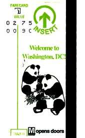
The contract for Metro's fare collection system was awarded in 1975 to Cubic Transportation Systems.[90] Electronic fare collection using paper magnetic stripe cards started on July 1, 1977, a little more than a year after the first stations opened. Prior to electronic fare collection, exact change fareboxes were used.[91] Metro's historic paper farecard system is also shared by Bay Area Rapid Transit, which Cubic won a contract for in 1974.[90] Any remaining value stored on the paper cards was printed on the card at each exit, and passes were printed with the expiration date.
Several adjustments were made to shift the availability of passes from paper tickets to SmarTrip cards in 2012 and 2013. In May 2014 Metro announced plans to retrofit more than 500 fare vending machines throughout the system to dispense SmarTrip cards, rather than paper fare cards, and eventually eliminate magnetic fare cards entirely.[92] This was completed in early December 2015 when the last paper farecard was sold.[93] The faregates stopped accepting paper farecards on March 6, 2016.[94][95]
Safety and security
Security
Metro planners designed the system with passenger safety and order maintenance as primary considerations. The open vaulted ceiling design of stations and the limited obstructions on platforms allow few opportunities to conceal criminal activity. Station platforms are built away from station walls to limit vandalism and provide for diffused lighting of the station from recessed lights. Metro's attempts to reduce crime, combined with how the station environments were designed with crime prevention in mind,[96] has contributed to Metro being among the safest and cleanest subway systems in the United States.[97] There are nearly 6,000 video surveillance cameras used across the system to enhance security.[98]
Metro is patrolled by its own police force, which is charged with ensuring the safety of passengers and employees. Transit Police officers patrol the Metro system and Metrobuses, and they have jurisdiction and arrest powers throughout the 1,500-square-mile (3,900 km2) Metro service area for crimes that occur on or against transit authority facilities, or within 150 feet (46 m) of a Metrobus stop. The Metro Transit Police Department is one of two U.S. police agencies that has local police authority in three "state"-level jurisdictions (Maryland, Virginia, and the District of Columbia), the U.S. Park Police being the other.[99]
Each city and county in the Metro service area has similar ordinances that regulate or prohibit vending on Metro-owned property, and which prohibit riders from eating, drinking, or smoking in Metro trains, buses, and stations; the Transit Police have a reputation for enforcing these laws rigorously. One widely publicized incident occurred in October 2000 when police arrested 12-year-old Ansche Hedgepeth for eating french fries in the Tenleytown-AU station.[100] In a 2004 opinion by John Roberts, now Chief Justice of the United States, the D.C. Circuit Court of Appeals upheld Hedgepeth's arrest.[101] By then WMATA had answered negative publicity by adopting a policy of first issuing warnings to juveniles, and arresting them only after three violations within a year.
Metro's zero-tolerance policy on food, trash and other sources of disorder embodies the "broken windows" philosophy of crime reduction. This philosophy also extends to the use of station restroom facilities. A longstanding policy, intended to curb unlawful and unwanted activity, has been to only allow employees to use Metro restrooms.[97] Station managers may make exceptions for passengers with small children, the elderly, or the disabled.[102] Metro now allows the use of restrooms by passengers who gain a station manager's permission, except during periods of heightened terror alerts.[103]
Random bag searches
On October 27, 2008, the Metro Transit Police Department announced plans to immediately begin random searches of backpacks, purses, and other bags. Transit police would search riders at random before boarding a bus or entering a station. It also explained its intent to stop anyone acting suspiciously.[104] Metro claims that the United States Court of Appeals for the Second Circuit decision in MacWade v. Kelly,[105] which upheld random searches on the New York City Subway, allows Metro Transit Police to take similar action.[106] Metro Transit Police Chief Michael Taborn stated that, if someone were to turn around and simply enter the system through another escalator or elevator, Metro has "a plan to address suspicious behavior".[107] Security expert Bruce Schneier characterized the plan as "security theater against a movie plot threat" and does not believe random bag searches actually improve security.[108]
The Metro Riders' Advisory Council recommended to WMATA’s board of directors that Metro hold at least one public meeting regarding the search program. As of December 2008, Metro had not conducted a single bag search.[109]
In 2010 Metro once again announced that it would implement random bag searches, and conducted the first such searches on December 21, 2010.[110] The searches consist of swabbing bags and packages for explosive residue, and X-raying or opening any packages which turned up positive. On the first day of searches, at least one false positive for explosives was produced, which Metro officials indicated could occur for a variety of reasons including if a passenger had recently been in contact with firearms or been to a firing range.[111] The DC Bill of Rights Coalition and the Montgomery County Civil Rights Coalition circulated a petition against random bag searches, taking the position that the practice violates the Fourth Amendment to the United States Constitution and would not improve security.[112] On January 3, 2011, Metro held a public forum for the searches at a Metro Riders' Advisory Council meeting, at which more than 50 riders spoke out, most of them in opposition to the searches. However at the meeting Metro officials called random bag inspections a "success" and claimed that few riders had complained.[113]
Safety
Accidents and incidents
Several collisions have occurred on Washington Metro, resulting in injuries and fatalities, along with numerous derailments with few or no injuries. WMATA has been criticized for disregarding safety warnings and advice from experts. The Tri-State Oversight Committee oversaw WMATA, but had no regulatory authority. Metro's safety department is usually in charge of investigating incidents, but could not require other Metro departments to implement its recommendations.[114] Following several safety lapses, the Federal Transit Administration assumed oversight at WMATA.[115]
Collisions
During the Blizzard of 1996, on January 6, a Metro operator was killed when a train failed to stop at the Shady Grove station. The four-car train overran the station platform and struck an unoccupied train that was awaiting assignment. The National Transportation Safety Board (NTSB) investigation found that the crash was a result of a failure in the train's computer-controlled braking system. The NTSB recommended that Metro grant train operators the ability to manually control the braking system, even in inclement weather, and recommended that Metro prohibit parked rail cars on tracks used by incoming outbound trains.[116]
On November 3, 2004, an out-of-service Red Line train rolled backwards into the Woodley Park station, hitting an in-service train stopped at the platform. The rear car (1077) was telescoped by the first car of the standing train (4018). No one was killed, but 20 people were injured.[117] A 14-month investigation concluded that the train operator was most likely not alert as the train rolled backwards into the station. Safety officials estimated that had the train been full, at least 79 people would have died. The train operator was dismissed and Metro officials agreed to add rollback protection to more than 300 rail cars.[118]
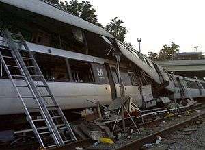
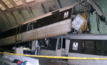
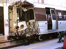
On June 22, 2009, at 5:02 pm, two trains on the Red Line collided. A southbound train heading toward Shady Grove stopped on the track short of the Fort Totten station and another southbound train collided with its rear. The front car of the moving train (1079) was telescoped by the rear car of the standing train (5066),[119] and passengers were trapped. Nine people died and more than 70 were injured, dozens of whom were described as "walking wounded".[120] Red Line service was suspended between the Fort Totten and Takoma stations, and New Hampshire Avenue was closed.[121][122] One of the dead was the operator of the train that collided with the stopped train.
On November 29, 2009, at 4:27 am, two trains collided at the West Falls Church train yard. One train pulled in and collided into the back of the other train. No customers were aboard, and only minor injuries to the operators and cleaning staff were reported. However, three cars (1106, 1171, and 3216) were believed to be damaged beyond repair.[123]
Derailments
On January 13, 1982, a train derailed at a malfunctioning crossover switch south of the Federal Triangle station. In attempting to restore the train to the rails, supervisors failed to notice that another car had also derailed. The other rail car slid off the track and hit a tunnel support, killing three people and injuring 25. Coincidentally, this accident occurred about 30 minutes after Air Florida Flight 90 crashed into the nearby 14th Street Bridge during a major snowstorm.[15]
On January 20, 2003, during construction of a new canopy at the National Airport station, Metro began running trains through the center track even though it had not been constructed for standard operations, and a Blue Line train derailed at the switch. No injuries resulted but the accident delayed construction by a number of weeks.[124]
On January 7, 2007, a Green Line train carrying approximately 120 people derailed near the Mount Vernon Square station in downtown Washington. Trains were single-tracking at the time, and the derailment of the fifth car occurred where the train was switching from the south to northbound track. The accident injured at least 18 people and prompted the rescue of 60 people from a tunnel.[125] At least one person had a serious but non-life-threatening injury.[126]
The Mount Vernon Square accident was one of a series of five derailments involving 5000-Series cars, with four of those occurring on side tracks and not involving passengers.[126]
On June 9, 2008, an Orange Line train (2000-series) derailed between the Rosslyn and Court House stations.[127][128]
On February 12, 2010, a Red Line train derailed at about 10:13 am as it left the Farragut North station in downtown Washington. After leaving the station, the train entered the pocket track north of the station. As it continued, an automatic derailer at the end of the pocket track intentionally derailed the train as a safety measure. If the train had continued moving forward on the pocket track, it would have entered the path of an oncoming train. The wheels of the first two cars in the six-car, White-Flint-bound train were forced off the tracks, stopping the train. Almost all of the estimated 345 passengers were evacuated from the damaged train by 11:50 am and the NTSB arrived on the accident scene by noon. Two minor injuries were reported, and a third passenger was taken to George Washington University Hospital.[129] The NTSB ruled the accident was due to the train operator's failure to follow standard procedures and WMATA management for failure to provide proper supervision of the train operator which resulted in the incomplete configuration of the train identification and destination codes leading to the routing of the train into the pocket track.[130]
On April 24, 2012, around 7:15 pm, a Blue Line train bound for Franconia–Springfield derailed near Rosslyn. No injuries were reported.[131]
On July 6, 2012, around 4:45 pm, a Green Line train bound for downtown Washington, DC and Branch Avenue derailed near West Hyattsville. No injuries were reported. A heat kink, due to the hot weather, was identified as the probable cause of the accident.[132]
On August 6, 2015, a non-passenger train derailed outside Smithsonian station. The track condition that caused the derailment had been detected a month earlier but was not repaired.[133]
On July 29, 2016, a Silver Line train heading in the direction of Wiehle-Reston East station derailed outside East Falls Church station. Service was suspended between Ballston and West Falls Church and McLean stations on the Orange and Silver Lines.[134]
On September 1, 2016, Metro announced the derailment of an empty six-car train in the Alexandria Rail Yard. No injuries or service interruptions have been reported and an investigation is ongoing.[135]
Safety measures
On July 13, 2009, WMATA adopted a "zero tolerance" policy for train or bus operators found to be texting or using other hand-held devices while on the job. This new and stricter policy came after investigations of several mass-transit accidents in the U.S. found that operators were texting at the time of the accident. The policy change was announced the day after a passenger of a Metro train videotaped the operator texting while operating the train.[136]
Smoke incidents
On January 12, 2015, during early evening rush, a Yellow Line train stopped in the tunnel and filled with smoke just after departing L'Enfant Plaza for Pentagon due to "an electrical arcing event" ahead in the tunnel. Everyone on board was evacuated; 84 people were taken to hospitals and one person died.[137]
On March 14, 2016, an electrified rail caught fire between McPherson Square and Farragut West, causing significant disruptions on the Blue, Orange, and Silver lines. On March 15, a decision was made to close the entire rail network the following day to inspect the network's entire electric rail power grid.[138]
Future expansion
WMATA expects an average of one million riders daily by 2030. The need to increase capacity has renewed plans to add 220 cars to the system and reroute trains to alleviate congestion at the busiest stations.[139] Population growth in the region has also revived efforts to extend service, build new stations, and construct additional lines.
Silver Line
The most prominent expansion is the Dulles Corridor Metrorail Project, dubbed the Silver Line, a 23-mile (37 km) extension from the Orange Line into Loudoun County, Virginia, by way of Tysons Corner and Washington Dulles International Airport. Rail to Dulles has been discussed since the system opened in 1976. The current Silver Line project was formally proposed in 2002 and initially approved by the Federal Transit Administration in 2004.[140] After several delays, federal funding for Phase 1 was secured in December 2008[141] and construction began in March 2009.[142] The line is being constructed in two phases; the first phase to Wiehle – Reston East in Reston, Virginia opened July 26, 2014,[143] and the second phase to Virginia Route 772, beyond Dulles Airport, is projected for completion in 2019 or 2020.[144]
Blue Line realignment
Blue Line trains share a single tunnel with Orange Line and Silver Line trains to cross the Potomac River. The current tunnel limits service in each direction, creating a choke point. A 2001 proposal would have rerouted the Blue Line between the Rosslyn and Stadium–Armory stations by building a bridge or tunnel from Virginia to a new station in Georgetown.[145] The proposal was later rejected due to cost,[146] but Metro again started considering a similar scenario in 2011.[147]
Orange Line extension
The Virginia Department of Transportation (VDOT) announced on January 18, 2008, that it and the Virginia Department of Rail and Public Transportation (VDPRT) had begun work on a draft environmental impact statement (EIS) for the I-66 corridor in Fairfax and Prince William counties. According to VDOT the EIS, officially named the I-66 Multimodal Transportation and Environment Study, would focus on improving mobility along I-66 from the Capital Beltway (I-495) interchange in Fairfax County to the interchange with U.S. Route 15 in Prince William County. The EIS also allegedly includes a four-station extension of the Orange Line past Vienna. The extension would continue to run in the I-66 median and would have stations at Chain Bridge Road, Fair Oaks, Stringfellow Road and Centreville near Virginia Route 28 and U.S. Route 29.[148] In its final report published June 8, 2012, the study and analysis revealed that an "extension would have a minimal impact on Metrorail ridership and volumes on study area roadways inside the Beltway and would therefore not relieve congestion in the study corridor."[149]
Fort Belvoir and Fort Meade extensions
In 2005 the Defense Department announced that it would be shifting 18,000 jobs to Fort Belvoir in Virginia and at least 5,000 jobs to Fort Meade in Maryland by 2012, as part of that year's Base Realignment and Closure plan. In anticipation of such a move, local officials and the military proposed extending the Blue and Green Lines to service each base. The proposed extension of the Green Line could cost $100 million per mile ($60 million per kilometer), and a light rail extension to Fort Belvoir was estimated to cost up to $800 million. Neither proposal has established timelines for planning or construction.[150][151]
Potomac Yard station
In 2008 officials began to explore the possibility of adding an infill station called Potomac Yard in the Potomac Yard area of Alexandria, on the Blue and Yellow Lines between the National Airport and Braddock Road stations. In 2010 the Alexandria City Council approved a portion of the proposed $240 million construction of the station. If the council approves the final budget, construction would start in 2017 and the station would be scheduled to open in late 2018 or early 2019.[152]
Other new rail lines
In 2011 Metro began studying the needs of the system through 2040.[147] New Metro rail lines and extensions under consideration as part of this long term plan include: a new line which parallels the Capital Beltway; a new line from the Friendship Heights Metro station to White Oak, Maryland, which would pass through the District and Silver Spring; an extension of the Green Line to National Harbor in Maryland; and re-routing the Blue Line in the District between the Orange Line and Green Line. None of these lines are yet funded for planning or construction.[147]
Related non-WMATA projects
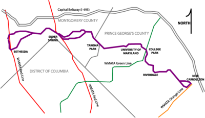
A number of light rail and urban streetcar projects have been proposed to extend or supplement service provided by Metro. Like the Silver Line in Virginia, the proposed Purple Line has been in planning since the 1980s.[153] The project was originally envisioned as a circular heavy rail line connecting the outer stations on each branch of the Metrorail system, in a pattern roughly mirroring the Capital Beltway.[154] The current proposal would create a light rail system in Maryland between the Bethesda and New Carrollton stations by way of Silver Spring and College Park. Such a plan would connect both branches of the Red Line to the Green and Orange Lines, and would decrease the travel time between suburban Metro stations.[153][155]
The Corridor Cities Transitway (CCT) is a proposed 15 miles (24 km) bus rapid transit line that would link Clarksburg, Maryland in northern Montgomery County with the Shady Grove station on the Red Line.[156] Assuming that the anticipated federal, state, and local government funds are provided, construction of the first 9 miles (14 km) of the system would begin in 2018.[157]
In 2005 a Maryland lawmaker proposed a light rail system to connect areas of Southern Maryland, especially the rapidly growing area around the town of Waldorf, to the Branch Avenue station on the Green Line. The project is still in the planning stages.[158]
The District of Columbia Department of Transportation is building the new DC Streetcar system to improve transit connectivity within the District. A tram line to connect Bolling Air Force Base to the Anacostia station and was originally expected to open in 2010. Streetcar routes have been proposed in the Atlas District, Capitol Hill, and the K Street corridor.[159] After seven years of construction, the Atlas District route, known as the H/Benning Street route, opened on February 27, 2016.[160]
See also
- List of metro systems
- List of United States rapid transit systems by ridership
- Transportation in Washington, D.C.
- United States Capitol Subway System
References
- ↑ "Transit Ridership Report Second Quarter 2016" (pdf). American Public Transportation Association. August 22, 2016. Retrieved 2016-11-14 – via http://www.apta.com/resources/statistics/Pages/ridershipreport.aspx.
- ↑ "Transit Ridership Report Fourth Quarter 2015" (pdf). American Public Transportation Association. March 2, 2016. Retrieved 2016-03-19 – via http://www.apta.com/resources/statistics/Pages/ridershipreport.aspx.
- ↑ Duggan, Paul; Aratani, Lori (November 19, 2015). "For Metro's new chief executive, angry riders and stubborn problems await". The Washington Post. Retrieved November 23, 2015.
- 1 2 "WMATA Summary – Level Rail Car Performance For Design And Simulation" (PDF). WMATA. 2013-10-13. Retrieved October 15, 2014.
- ↑ Schrag, Zachary (2006). "Introduction". The Great Society Subway: A History of the Washington Metro. Baltimore, Maryland: The Johns Hopkins University Press. p. 9. ISBN 0-8018-8246-X.Google Books search/preview
- ↑ Washington Metropolitan Area Transit Authority, Frequently Asked Questions, accessed July 2009: "What do I need to know to build near Metro property? Metro reviews designs and monitors construction of projects adjacent to Metrorail and Metrobus property..."
- ↑ "About Metro". Washington Metropolitan Area Transit Authority. 2014. Retrieved August 28, 2014.
- ↑ "Metro launches Silver Line, largest expansion of region's rail system in more than two decades" (Press release). Washington Metropolitan Area Transit Authority. July 25, 2014. Retrieved August 4, 2014.
- ↑ Dawson, Christie (December 4, 2008). "Heavy Rail Rapid Transit Ridership Report, Third quarter 2008" (PDF). American Public Transportation Association. Archived from the original (PDF) on February 6, 2009. Retrieved January 27, 2009.
- ↑ "Metrorail Average Weekly Passenger Boardings" (PDF). Washington Metropolitan Area Transit Authority. Retrieved January 18, 2016.
- 1 2 "215 million people rode Metro in fiscal year 2008". WMATA. July 8, 2008. Retrieved January 27, 2009.
- ↑ Metro Facts. Washington Metropolitan Area Transit Authority. Accessed September 14, 2010.
- ↑ "Harland Bartholomew: His Contributions to American Urban Planning" (PDF). American Planning Association. Retrieved November 22, 2006.
- ↑ Schrag, Zachary (2006). The Great Society Subway: A History of the Washington Metro. Baltimore, Maryland: The Johns Hopkins University Press. ISBN 0-8018-8246-X.
- 1 2 3 "WMATA History" (PDF). WMATA. Retrieved February 3, 2011.
- 1 2 Schrag, Zachary M. "Planning: The Adopted Regional System, 1966–1968". Retrieved August 17, 2006.
- ↑ Eisen, Jack (December 10, 1969). "Ground Is Broken On Metro, Job Let: Earth Is Turned On Metro, Job Let". The Washington Post. p. 1.
- ↑ Eisen, Jack (March 28, 1976). "Metro Opens: Crowds Stall Some Trains". The Washington Post. p. 1.
- ↑ "D.C. will open new leg of its subway today". The Baltimore Sun. Associated Press. July 1, 1977. p. D2.
- ↑ Feaver, Douglas B.; Johnson, Janis (February 7, 1978). "Metro Section Opens: Few Flaws, Happy Riders". The Washington Post. p. A1.
- ↑ "Metro's Orange Line Begins Service Today". The Washington Post. November 20, 1978. p. C1.
- ↑ Lynton, Stephen J. (December 18, 1983). "Metro Extension Opens With Flourish: Yellow Line Opened to Huntington Alexandria Welcomes Yellow Line". The Washington Post. p. B1.
- ↑ Luz Lazo, "Riders: Let there be light"; Express (Washington, D.C.), Dec 3, 2012, p. 12.
- ↑ Martin, Douglas (27 May 2014). "Massimo Vignelli, a Visionary Designer Who Untangled the Subway, Dies at 83". New York Times. Retrieved May 28, 2014.
- ↑ "Dulles Metrorail Project Overview". WMATA. Retrieved June 22, 2011.
- ↑ "About the Silver Line". WMATA. Retrieved August 3, 2014.
- ↑ Shyam (February 24, 2014). "Gut Check – Funding Metro 2025". planitmetro.com. Washington Metropolitan Area Transit Authority. Retrieved February 24, 2014.
- ↑ "Metro sets new record for highest ridership day of all time" (Press release). WMATA. January 21, 2009.
- ↑ Layton, Lyndsey (February 2, 2006). "Metro Chooses New 'Doors' Voice". The Washington Post. p. B01.
- ↑ Joanna Malloy and Corky Siemaszko (November 1, 2010). "Jon Stewart 'Rally to Restore Sanity' crowds set new record for DC transit with 825,437 trips". (New York) Daily News. New York. Retrieved June 22, 2011.
- ↑ "Metro sets new record for highest Saturday Metrorail ridership" (Press release). WMATA. October 31, 2010.
- ↑ "Evolution of Metrorail".
- ↑ "William Lam, 87; architect made lighting part of design". Boston.com.
- ↑ Lam, Willian (1977). Perception and Lighting as Formgivers for Architecture. New York: McGraw Hill. p. 293. ISBN 0070360944. Retrieved March 22, 2015.
- ↑ "Metro has eleven types of station architecture. Learn them all with this one interactive map.". Greater Greater Washington.
- ↑ Mortice, Zach. "2014 Twenty-five Year Award". American Institute of Architects. American Institute of Architects. Retrieved February 11, 2014.
- 1 2 3 4 5 6 "2015 Metro Facts" (PDF). Washington Metropolitan Area Transit Authority (WMATA). 2015. Retrieved March 15, 2016.
- ↑ "Construction". Metropolitan Washington Airports Authority. Retrieved April 21, 2009.
- ↑ Dana Hedgpeth, "After more than 30 years, Metro map is being redesigned by creator Lance Wyman", The Washington Post, June 4, 2011.
- ↑ "Metro". Retrieved February 4, 2012.
- ↑ "Metro launches retail at Smithsonian Metrorail station". WMATA. Retrieved April 7, 2011.
- ↑ Mullins, Luke, "The Infuriating History of How Metro Got So Bad", The Washingtonian, 9 December 2015
- ↑ WMATA (2014-05-22). "FY2015 Approved Budget Effective July 1, 2014.". Percentage calculated from figures in Table 2.1, p. II-14; and Table 3.3, p. III-3. $696 mil./$1022.6 mil = 66%.
- ↑ "Dulles Metrorail Project Overview". Metropolitan Washington Airports Authority. Retrieved January 28, 2009.
- ↑ Walsk, Sean Collins (July 1, 2011). "For Washington, a Trek to Daylight". New York Times. Retrieved July 26, 2012.
- ↑ "Discover A New Horizon". Rosslyn Magazine. 1 (2): 21. Summer 2006.
- 1 2 "Media Guide 2008" (PDF). WMATA. Retrieved January 28, 2009.
- 1 2 "Core Stations Capacity Enhancements" (PDF). WMATA. October 21, 2008. Retrieved January 28, 2009.
- ↑ "Metro launches Farragut Crossing" (Press release). Washington Metropolitan Area Transit Authority. October 28, 2011. Retrieved January 6, 2012.
- 1 2 "Tuesday Red Line service altered as a result of Monday collision". WMATA press release. June 23, 2009. Retrieved June 23, 2009.
- ↑ "Glossary". WMATA. Retrieved January 28, 2009.
- ↑ "Metrorail system adds trains to fleet" (Press release). WMATA. April 9, 2009. Retrieved July 16, 2009.
- ↑ "NTSB Accident Report RAR-06-01, Collision Between Two Washington Metropolitan Area Transit Authority Trains at the Woodley Park- Zoo/Adams Morgan Station in Washington, D.C. November 3, 2004" (PDF). National Transportation Safety Board. p. 56. Retrieved May 4, 2009.
- ↑ "Railcars Semi-Annual Update" (PDF). Washington Metropolitan Area Transit Authority. February 8, 2007. Retrieved January 28, 2009.
- ↑ "7000 Series Railcar Program: Overview" (PDF). WMATA. September 25, 2008. Retrieved January 28, 2009.
- ↑ Scott Tyson, Ann (July 28, 2010). "Red Line crash was inevitable, NTSB finds". Washington Post. p. A1.
- ↑ Tuss, Adam (March 22, 2010). "Metro's oldest rail cars will be rolling out of service". WTOP. Retrieved July 28, 2010.
- ↑ "Washington orders more Kawasaki metro cars". Railway Gazette International. May 22, 2013. Retrieved May 22, 2013.
- ↑ "Metro's first 7000-series train to debut April 14 on the Blue Line".
- ↑ Duggan, Paul (May 27, 2015). "Waiting for federal approval, Metro's planned purchase of rail cars at risk". The Washington Post. Retrieved June 3, 2015.
- ↑ "Precision Station Stopping Progress Update" (PDF). WMATA. March 21, 2005. Retrieved January 27, 2009.
- ↑ Hohmann, James (August 19, 2009). "After Fatal Crash, Metro Still Wary Of Letting Computers Control Trains". The Washington Post.
- ↑ Customer Services, Operations, and Safety Committee, "Manual vs. Automatic Operation and Operational Restrictions," Information Item IV-B, Washington Metropolitan Area Transit Authority Board, March 11, 2010.
- ↑ "Computer-driven trains returning to Metro's Red Line five years after deadly rail crash". The Washington Post. September 20, 2014. Retrieved September 20, 2014.
- ↑ "Metro - Rail - Stations". WMATA. Retrieved May 29, 2016.
- ↑ Michael Perkins, "Metro Headway Policy Needs Clarity," Greater Greater Washington, August 23, 2012.
- ↑ Luke Roziak, "Metro Eyes 12 AM Weekend Closing," Washington Post, February 11, 2011.
- ↑ J. Freedom DuLac et al., "Metro's proposal to end late-night weekend trains rankles Washington's party crowd" Washington Post, February 13, 2011.
- ↑ "Metro GM releases draft 'SafeTrack' plan to local jurisdictions" (Press release). WMATA. May 6, 2016. Retrieved May 7, 2016.
- ↑ http://www.wmata.com/about_metro/news/PressReleaseDetail.cfm?ReleaseID=6140
- ↑ "July 4th, 2005 Operations Plan" (PDF). WMATA. June 16, 2005. Retrieved January 28, 2009.
- ↑ "Several Metrorail stations to be entry/exit only on Inauguration Day". WMATA. January 13, 2009. Retrieved January 28, 2009.
- ↑ WMATA (March 26, 2004). "Metro offers enhancements for the passenger information display monitors." News release.
- ↑ WMATA. "Mobile Services." Accessed November 19, 2012.
- ↑ WMATA (August 6, 2010). "Metro invites software developers to discuss new transit data feed." News release.
- ↑ WMATA. "Developer Resources." Accessed November 19, 2012.
- ↑ WMATA (August 31, 2010). "Real-time next train arrival information now available by phone." News release.
- ↑ "How to Use Metrorail Faregates, Farecards, and Passes". WMATA. Retrieved January 27, 2009.
- 1 2 "Metrorail Fares". WMATA. Retrieved September 17, 2014.
- ↑ "General Manager's Fiscal 2008 Proposed Operating and Capital Budgets" (PDF). WMATA. December 14, 2006. Retrieved January 27, 2009.
- ↑ "Metro Pass and Farecard Options". Retrieved January 27, 2009.
- ↑ "Metro fare change effective July 1, 2012". WMATA.
- ↑ "Metro to launch unlimited 'short trip' Metrorail pass on SmarTrip cards" (Press release). WMATA. May 16, 2013.
- ↑ "Metro introduces unlimited 7-day rail pass on SmarTrip®" (Press release). WMATA. April 16, 2012.
- ↑ "Metro - Fares - Select Pass". WMATA. Retrieved October 15, 2016.
- ↑ "Metro expands SelectPass options, more than $1 million in sales since launch of pilot" (Press release). WMATA. August 22, 2016.
- ↑ "Metro Select Pass – Select. Ride. Save.". WMATA. Retrieved October 13, 2016.
- ↑ "Metro launches Farragut Crossing" (Press release). WMATA. October 28, 2011.
- ↑ Hauslohner, Abigail (August 17, 2015). "D.C. students will be riding Metro for free this year". The Washington Post. Retrieved August 26, 2015.
- 1 2 "40 years of Cubic transport success". Collection Point. No. 18. Cubic Transportation Systems. October 2012. p. 18. Archived from the original on November 13, 2013.
1975 Cubic wins $54 million contract to provide system for Washington DC
- ↑ "Metro History" (PDF). Washington Metropolitan Area Transit Authority. Retrieved January 18, 2016.
- ↑ "Upgrade to fare vending machines puts Metro on path to eventually eliminate paper farecards" (Press release). WMATA. May 21, 2014.
- ↑ "Metro Sells Last Paper Farecard". NBC Washington. Associated Press. December 3, 2015. Retrieved March 20, 2016.
- ↑ "Metro reaches "paperless" milestone; all fare machines now selling SmarTrip® only" (Press release). WMATA. December 3, 2015. Retrieved February 5, 2016.
- ↑ "Paper Farecard Elimination". WMATA. Retrieved March 20, 2016.
Starting 7:00am Sunday, March 6, 2016, a SmarTrip® card is required to ride Metrorail. Metro has completed its efforts to eliminate paper farecards
- ↑ La Vigne, Nancy G. (November 1997). "Visibility and Vigilance: Metro's Situational Approach to Preventing Subway Crime (Research in Brief)" (PDF). National Institute of Justice, U.S. Department of Justice.
- 1 2 La Vigne, Nancy G. (1996). "Safe Transport: Security by Design on the Washington Metro (Chapter 6)". In Clarke, Ronald V. (editor). Preventing Mass Transit Crime. Criminal Justice Press. ISBN 1-881798-28-3.
- ↑ "Metro Plans to Triple Number of Security Cameras". NBC Washington. April 1, 2013. Retrieved October 31, 2015.
- ↑ "Metro Transit Police". WMATA. Retrieved August 19, 2006.
- ↑ Sullivan, Emmet G. (September 30, 2003). "Hedgepeth v. WMATA, et al." (PDF). United States District Court for the District of Columbia.
- ↑ Hedgepeth v. Washington Metropolitan Area Transit Authority, 386 F.3d 1148 (D.C. Cir. 2004) (Argued September 17, 2004 decided October 26, 2004)
- ↑ Layton, Lyndsey (January 5, 2003). "If You Have to Go, Perhaps Soon You Can Go on Metro". The Washington Post. p. C04.
- ↑ "Metro steps up security as a precaution after foiled London terror plot" (Press release). WMATA. August 10, 2006.
- ↑ Lena H. Sun (October 28, 2008). "Metro to Randomly Search Riders' Bags". The Washington Post. p. A01.
- ↑ Appeals court decision: Brieant, Charles L.; Newman and Straub; Circuit Judges (August 11, 2006). "Brendan MacWade and four other Plaintiffs v. Raymond Kelly, Defendant". aele.org. Americans for Effective Law Enforcement. Retrieved November 7, 2009. Original complaint: New York Civil Liberties Foundation (August 4, 2005). "MacWade v. Kelly" (PDF). FindLaw. Retrieved November 7, 2009.
- ↑ "News Q & A: MTPD Security Inspection Program". WMATA. Retrieved January 27, 2009.
- ↑ Taborn, Michael (October 28, 2008). "Metro Transit's Top Cop Discusses New Search Policy". The Washington Post. Retrieved January 27, 2009.
- ↑ "Bruce Schneier Talks Metro Bag Searches". The Washington Post. October 31, 2008. Retrieved January 27, 2009.
- ↑ Dr. Gridlock (December 7, 2008). "Discussion Overdue On Metrorail's Bag-Search Policy". The Washington Post. p. C02.
- ↑ "Metro Begins Random Bag Searches". MSNBC. December 21, 2010.
- ↑ "Metro bag inspections cause minor customer annoyances". Washington Post. December 21, 2010.
- ↑ "Groups Launch Petition Against Metro Bag Searches". MSNBC. December 20, 2010.
- ↑ "Metro riders sound off on bag searches". WTOP. January 4, 2011.
- ↑ Becker, Jo; Lyndsey Layton (June 6, 2005). "Safety Warnings Often Ignored at Metro". The Washington Post. Retrieved June 25, 2009.
- ↑ https://www.washingtonpost.com/local/trafficandcommuting/federal-officials-will-assume-responsibility-for-metro-safety/2015/10/09/8fe4cae6-6eca-11e5-aa5b-f78a98956699_story.html
- ↑ "Railroad Accident Report: Collision of Washington Metropolitan Area Transit Authority Train T-111 with Standing Train at Shady Grove Passenger Station, Gaithersburg, Maryland, January 6, 1996" (PDF). National Transportation Safety Board. October 29, 1996. Retrieved January 27, 2009.
- ↑ Layton, Lyndsey; Steven Ginsberg (November 4, 2004). "20 Injured in Crash of 2 Red Line Trains". The Washington Post. pp. A01. Retrieved January 27, 2009.
- ↑ Sun, Lena H. (March 23, 2006). "Dozing Operator Blamed in Rail Accident". The Washington Post. p. A01.
- ↑ "NTSB Abstract RAR-10/02" (PDF). National Transportation Safety Board.
- ↑ "Metro: Train operator not using cell phone – wtop.com". Wtopnews.com. June 25, 2009. Retrieved July 16, 2009.
- ↑ "Photos from the scene". Myfoxdc.com. Archived from the original on June 26, 2009. Retrieved July 16, 2009.
- ↑ "9 Killed, 76 Injured in Deadliest Disaster in Metro History|ABC 7 News". Wjla.com. June 23, 2009. Retrieved July 16, 2009.
- ↑ "Two six-car trains collide inside Metro rail yard" (Press release). Washington Metropolitan Area Transit Authority. November 29, 2009. Retrieved August 20, 2010.
- ↑ Layton, Lyndsey (February 27, 2003). "Metro track blamed in derailment – Section not made for regular use". The Washington Post. p. A1.
- ↑ Klein, Allison; Martin Well (January 8, 2007). "Green Line Metro Train Derails; at Least 18 Hurt". The Washington Post. pp. A01. Retrieved June 24, 2009.
- 1 2 Weiss, Eric M. (January 9, 2007). "Federal Investigators Question Metro's Safety". The Washington Post. pp. A01. Retrieved January 27, 2009.
- ↑ Sun, Lena H.; Daniela Dean (June 10, 2008). "Metro Train Derails, Causing Major Delays". The Washington Post. pp. B01. Retrieved June 24, 2009.
- ↑ Sun, Lena H. (June 11, 2008). "Metro Says Operator Wasn't First to Detect Derailment". The Washington Post. pp. B01. Retrieved June 24, 2009.
- ↑ "D.C. Metro train derails at Farragut North". Washington Post. February 12, 2010. Retrieved February 13, 2010.
- ↑ "Railroad Accident Brief, Accident DCA-10-FR-004" (PDF) (PDF).
- ↑ Weil, Marin; Hedgpeth, Dana (April 24, 2012). "Metro delayed after Rosslyn derailment; no injuries reported". The Washington Post. Retrieved April 27, 2012.
- ↑ "Investigators identify heat kink as probable cause of Friday derailment" (Press release). WMATA. July 7, 2012.
- ↑ Siddiqui, Faiz; Aratani, Lori (August 12, 2015). "Cause of last week's Metro derailment had been detected in early July". The Washington Post. Retrieved January 18, 2016.
- ↑ "Portions of Orange and Silver lines to remain closed following Metro derailment". WTOP. July 29, 2016. Retrieved July 29, 2016.
- ↑ Mann/ABC7, Kendra. "Metro: 6-car train derails at Alexandria Yard; no passengers on-board". Retrieved 2016-09-02.
- ↑ John Hughes (July 9, 2009). "Washington Metro Train Operators Caught Texting Will Be Fired". Bloomberg.
- ↑ Jaffe, Christopher (January 13, 2015). "1 dead after smoke shuts down D.C. metro station". politics. CNN. Retrieved January 18, 2016.
- ↑ "All Metrorail service will be suspended Wednesday, March 16, for emergency inspections" (Press release). Washington Metropolitan Area Transit Authority. March 15, 2016. Retrieved March 16, 2016.
- ↑ "Metro details improvements to meet future capacity needs". WMATA. April 18, 2008. Retrieved December 8, 2008.
- ↑ "Dulles Metrorail is Coming" (PDF). Dulles Corridor Metrorail Project. April 2008. Retrieved January 25, 2009.
- ↑ Gardner, Amy (December 4, 2008). "Silver Line To Dulles Wins Crucial Federal Okay". The Washington Post. p. A01. Retrieved December 7, 2008.
- ↑ "Project Timeline". Metropolitan Washington Airports Authority. Retrieved September 14, 2009.
- ↑ "Metro announces Silver Line opening date: Rail service to begin at noon Saturday, July 26" (Press release). Washington Metropolitan Area Transit Authority. June 23, 2014. Retrieved January 18, 2016.
- ↑ "Metro Long Range Planning". National Association to Restore Pride in America's Capital. Retrieved January 25, 2009.
- ↑ Whoriskey, Peter (April 15, 2005). "Choke Point Slows Orange Line Trains". The Washington Post. p. B01.
- 1 2 3 Kytja Weir (June 14, 2011). "Metro studies more rail lines for future". WashingtonExaminer.com. Retrieved June 22, 2011.
- ↑ "Northern Virginia Metrorail Extension Act of 2011". The Library of Congress. January 5, 2011. Retrieved December 31, 2012.
- ↑ Cambridge Systematics (June 8, 2012). "I-66 Multimodal Study: Inside the Beltway: Final Report" (PDF). Virginia Department of Transportation. pp. 2–6. Retrieved January 18, 2016.
extension would have a minimal impact on Metrorail ridership and volumes on study area roadways inside the Beltway and would therefore not relieve congestion in the study corridor.
- ↑ Smith, Leef (May 20, 2005). "Metro Studies Ft. Belvoir Extension". The Washington Post. p. B01.
- ↑ McGowan, Phillip (June 9, 2005). "Fort Meade proposes Metro extension". The Baltimore Sun.
- ↑ Sullivan, Patricia (December 23, 2010). "Alexandria chooses location for Potomac Yard Metro station". The Washington Post. Retrieved October 26, 2012.
- 1 2 Shaver, Katherine (January 23, 2009). "Leggett Endorses Light-Rail Plan". The Washington Post. p. B03. Retrieved January 26, 2009.
- ↑ "Where Would the Purple Line Go?". Sierra Club. Retrieved January 26, 2009.
- ↑ "About the Project". Maryland Transit Administration. Retrieved June 22, 2011.
- ↑ Montgomery County Planning Department, Silver Spring, MD. "Corridor Cities Transitway." Accessed October 15, 2013.
- ↑ Maryland Transit Administration. "Corridor Cities Transitway: Schedule." Accessed October 15, 2013.
- ↑ Paley, Amit (February 15, 2005). "Dyson Pushes Light Rail, Expansion of Bridge". The Washington Post. p. SM01.
- ↑ Sun, Lena (July 13, 2008). "Transit Plan on Track". The Washington Post. p. C01. Retrieved July 13, 2008.
- ↑ Malouff, Dan (February 29, 2016). "DC Streetcar's exuberant opening day, in photos and video". Greater Greater Washington. Retrieved March 2, 2016.
External links
| Wikimedia Commons has media related to: |
Official websites
- Washington Metropolitan Area Transit Authority Official site
- MetroForward channel on YouTube – official WMATA videos
- Metro Transit Police Official site
- Dulles Corridor Metrorail Project
- Tri-state Oversight Committee Official site
Transit enthusiast sites
- world.nycsubway.org Washington Metro
- The Schumin Web: Identifying Metro Cars
- Oren's Transit Page (Washington, D.C.)
- Washington-DC-Metro.com – A retired WMATA employee reflects on 27 years of insider experiences.
- UrbanRail.net Washington Metro
- John R. Cambron. "Various Documents, Pictures and Maps of Washington Metro". Archived from the original on April 9, 2007.
- "Home Page of John R Cambron". Archived from the original on 2014-09-02.
- Blog of Sand Box John (John R. Cambron)
- "The Pipeshaft: Infrastructure of the D.C. Metrorail". Archived from the original on April 17, 2007.
- GP Bus Gallery
- MetroSongs, folksongs about the DC Metro by Jason Mendelson
Maps
- DCRails.com Google Maps representation of Metrorail with address lookup.
- An alternate Google Maps representation showing all lines drawn in
- Archived versions: of a track map on nycsubway.org that was removed post-9/11 at the request of WMATA. Wheaton and Forest Glen stations are shown with a single island platform when they actually have two separate inside platforms connected by a passageway. The flying junction at Rosslyn is shown with the incorrect track on top (although the platforms are shown correctly). It fails to show the tail tracks at Huntington station.
- "Track schematic of 106 Mile System". Archived from the original (2127×989 12-2011) on 2015-04-20.
- "Track schematic of 129 mile system (Dulles Corridor Metrorail Project)". Archived from the original (2976×840 12-2013) on 2015-04-20.
- WMATA Comprehensive 129 Mile Area Regional System Track Schematic (9856×2005 11-2016)
- "Proposed 2030 Track schematic". Archived from the original (2864×1047 12-2013) on 2015-04-20.
- "Proposed 2040 Track schematic". Archived from the original (2925×1060 12-2013) on 2015-06-08.
- WMATA 140 Mile Proposed 2040 Area Regional System Track Schematic (7312×2650 12-2013)
- WMATA 140 Mile Proposed 2040 Area Regional System Track Schematic, My (John R Cambron’s) Version (7428×2650 12-2013)
- "Stationmasters, map of the Washington Metro with 360-degree photos of each station's surroundings and highly detailed local maps". Archived from the original on 2013-03-06.
Equipment
- "Document describing line nomenclature, operation and signaling". Archived from the original on February 10, 2007.
- "On Track With Added Value". Engineered Casting Solutions. November–December 2005. Archived from the original on October 20, 2006.
Other websites
- Dulles Corridor Rail Association
- StationMasters Online Neighborhood maps and panoramic photographs of each station
- MetroRiders.Org Metro Passenger Advocacy Group
- Building the Washington Metro
- How’s Metro? Live Metrorail status display
- Zachary M. Schrag (2006). The Great Society Subway: A History of the Washington Metro. JHU Press.
- Unsuck DC Metro Metro rider discussion forum.
- Metro Documentary produced by WETA-TV
| Subsidiaries | |
|---|---|
| Metrorail lines | |
| Bus rapid transit | |
| Future projects | |
| See also | |
| Common carriers |  | |
|---|---|---|
| Passenger carriers | ||
| Former carriers | ||