Washington County, Maryland
| Washington County, Maryland | |||
|---|---|---|---|
| County | |||
| Washington County | |||
 Burnside's Bridge in Washington County, site of heavy combat during the Battle of Antietam | |||
| |||
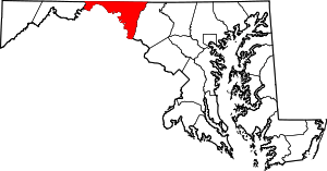 Location in the U.S. state of Maryland | |||
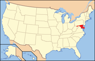 Maryland's location in the U.S. | |||
| Founded | September 6, 1776 | ||
| Named for | George Washington | ||
| Seat | Hagerstown | ||
| Largest city | Hagerstown | ||
| Area | |||
| • Total | 467 sq mi (1,210 km2) | ||
| • Land | 458 sq mi (1,186 km2) | ||
| • Water | 9.6 sq mi (25 km2), 2.0% | ||
| Population (est.) | |||
| • (2015) | 149,585 | ||
| • Density | 320/sq mi (124/km²) | ||
| Congressional district | 6th | ||
| Time zone | Eastern: UTC-5/-4 | ||
| Website |
www | ||


Washington County is a county located in the western part of the U.S. state of Maryland. As of the 2010 census, the population was 147,430.[1] Its county seat is Hagerstown.[2] Washington County was the first county in the United States to be named for the Revolutionary War general (and later President) George Washington. Washington County is one of three Maryland counties recognized by the Appalachian Regional Commission as being part of Appalachia.[3]
The county borders southern Pennsylvania to the north, Northern Virginia to the south, and the Eastern Panhandle of West Virginia to the south and west.
Washington County is included in the Hagerstown-Martinsburg, MD-WV Metropolitan Statistical Area, which is also included in the Washington-Baltimore-Arlington, DC-MD-VA-WV-PA Combined Statistical Area.
History
.png)
The western portions of Maryland (including present Washington County) were incorporated into Prince George's County in 1696. This original county included six current counties. The first to be created was Frederick, separated from Prince George's County in 1748.
Washington County was formed on September 6, 1776, by the division of Frederick County. At the same time, a portion of Frederick County became part of the newly created Montgomery County along with portions from Prince George's County and Charles' County, and was named for General Richard Montgomery. Washington County as created included land later to become Allegany County (created in 1789) and Garrett County (included in Allegany County when it was created in 1789, but separated from Allegany County in 1872). Washington County thus originally included the entire western part of the state.[4]
A number of properties in the county are listed on the National Register of Historic Places.[5]
Geography
According to the U.S. Census Bureau, the county has a total area of 467 square miles (1,210 km2), of which 458 square miles (1,190 km2) is land and 9.6 square miles (25 km2) (2.0%) is water.[6]
Washington County is located in the Appalachian Mountains, stretching from the Ridge-and-Valley Country in the west to South Mountain in the east, which is an extension of the Blue Ridge. Much of the county lies in the broad Hagerstown Valley between these two zones; the valley is part of the Great Appalachian Valley that continues southward into Virginia and West Virginia as the Shenandoah Valley and northward into Pennsylvania as the Cumberland Valley.
The county is bordered to the north by the Mason–Dixon line with Pennsylvania, to the south by the Potomac River and the states of Virginia and West Virginia, to the west by Sideling Hill Creek and Allegany County, Maryland, and to the east by Frederick County and South Mountain.
Adjacent counties
- Fulton County, Pennsylvania (northwest)
- Allegany County (west)
- Morgan County, West Virginia (southwest)
- Berkeley County, West Virginia (south)
- Jefferson County, West Virginia (south)
- Loudoun County, Virginia (southeast)
- Frederick County (east)
- Franklin County, Pennsylvania (northeast)
Major highways
.svg.png) Interstate 68
Interstate 68.svg.png) Interstate 70
Interstate 70.svg.png) Interstate 81
Interstate 81 U.S. Route 11
 U.S. Route 40
 U.S. Route 40 Alternate
 US 40 Scenic
 U.S. Route 340
 U.S. Route 522
 Maryland Route 34
 Maryland Route 56
 Maryland Route 57
 Maryland Route 58
 Maryland Route 60
 Maryland Route 62
 Maryland Route 63
 Maryland Route 64
 Maryland Route 65
 Maryland Route 66
 Maryland Route 67
 Maryland Route 68
 Maryland Route 77
 Maryland Route 144
 Maryland Route 180
 Maryland Route 418
 Maryland Route 491
 Maryland Route 494
 Maryland Route 550
 Maryland Route 615
 Maryland Route 632
Law and government
| Year | Republican | Democratic |
|---|---|---|
| 2012 | 57.5% 36,074 | 39.9% 25,042 |
| 2008 | 55.5% 34,169 | 42.6% 26,245 |
| 2004 | 63.8% 36,917 | 35.2% 20,387 |
| 2000 | 58.9% 27,948 | 38.4% 18,221 |
| 1996 | 50.9% 21,434 | 39.1% 16,481 |
| 1992 | 47.6% 21,977 | 35.7% 16,495 |
| 1988 | 63.8% 25,912 | 35.5% 14,408 |
| 1984 | 66.7% 27,118 | 32.8% 13,329 |
| 1980 | 52.4% 22,901 | 36.1% 14,118 |
| 1976 | 55.9% 20,194 | 44.1% 15,902 |
| 1972 | 69.3% 24,234 | 28.7% 10,039 |
| 1968 | 47.1% 16,050 | 33.1% 11,266 |
| 1964 | 39.1% 12,756 | 60.9% 19,858 |
| 1960 | 53.3% 17,828 | 46.7% 15,632 |
County government
Washington County's 'leader' is known as the County Administrator. Currently, Greg Murray serves as the Administrator. However, Washington County's County Commissioners exercise executive powers as they exist in the government of the county.
The County Commissioners in Washington County comprise the traditional form of county government in Maryland. Current members include: Terry Baker, President, John F. Barr, Vice-President and LeRoy E. Myers, Jeffrey A. Cline and William J. Wivell.[7]
State representation
Washington County is represented by two senators in the Maryland State Senate. Member George C. Edwards (R), serves the 1st district in Maryland and Andrew A. Serafini (R), serves in the 2nd district. The county also is represented in Maryland General Assembly's other primary division, the Maryland House of Delegates. Delegates who stand for Washington County include: Mike McKay (R) for District 1C, Neil Parrot (R) for District 2A (the other 2A seat is vacant) and Brett Wilson (R) for District 2B.[8]
Federal representation
The county is located within Maryland's 6th congressional district. The representative of the district currently is John Delaney (D).
Demographics
| Historical population | |||
|---|---|---|---|
| Census | Pop. | %± | |
| 1790 | 15,822 | — | |
| 1800 | 18,650 | 17.9% | |
| 1810 | 18,730 | 0.4% | |
| 1820 | 23,075 | 23.2% | |
| 1830 | 25,268 | 9.5% | |
| 1840 | 28,850 | 14.2% | |
| 1850 | 30,848 | 6.9% | |
| 1860 | 31,417 | 1.8% | |
| 1870 | 34,712 | 10.5% | |
| 1880 | 38,561 | 11.1% | |
| 1890 | 39,782 | 3.2% | |
| 1900 | 45,133 | 13.5% | |
| 1910 | 49,617 | 9.9% | |
| 1920 | 59,694 | 20.3% | |
| 1930 | 65,882 | 10.4% | |
| 1940 | 68,838 | 4.5% | |
| 1950 | 78,886 | 14.6% | |
| 1960 | 91,219 | 15.6% | |
| 1970 | 103,829 | 13.8% | |
| 1980 | 113,086 | 8.9% | |
| 1990 | 121,393 | 7.3% | |
| 2000 | 131,923 | 8.7% | |
| 2010 | 147,430 | 11.8% | |
| Est. 2015 | 149,585 | [9] | 1.5% |
| U.S. Decennial Census[10] 1790-1960[11] 1900-1990[12] 1990-2000[13] 2010-2015[1] | |||
2000 census
As of the census of 2010, there were 147,430 people, 49,726 households, and 34,112 families residing in the county. The population density was 315 people per square mile (111/km²). There were 52,972 housing units at an average density of 116 per square mile (45/km²). The racial makeup of the county was 89.71% White or Caucasian, 7.77% Black or African American, 0.18% Native American, 0.80% Asian, 0.04% Pacific Islander, 0.46% from other races, and 1.04% from two or more races. 1.19% of the population were Hispanic or Latino of any race. In the Census 2000, 32.1% identified as being of German ancestry, 21.4% American, 8.8% Irish, and 8.4% English ancestry.
There were 49,726 households out of which 31.30% had children under the age of 18 living with them, 54.00% were married couples living together, 10.70% had a female householder with no husband present, and 31.40% were non-families. 26.00% of all households were made up of individuals and 11.10% had someone living alone who was 65 years of age or older. The average household size was 2.46 and the average family size was 2.96.
In the county the population was spread out with 23.40% under the age of 18, 8.10% from 18 to 24, 31.30% from 25 to 44, 23.00% from 45 to 64, and 14.20% who were 65 years of age or older. The median age was 37 years. For every 100 females there were 104.50 males. For every 100 females age 18 and over, there were 104.00 males.
2010 census
As of the 2010 United States Census, there were 147,430 people, 55,687 households, and 37,506 families residing in the county.[14] The population density was 322.1 inhabitants per square mile (124.4/km2). There were 60,814 housing units at an average density of 132.8 per square mile (51.3/km2).[15] The racial makeup of the county was 85.1% white, 9.6% black or African American, 1.4% Asian, 0.2% American Indian, 1.1% from other races, and 2.6% from two or more races. Those of Hispanic or Latino origin made up 3.5% of the population.[14] In terms of ancestry, 31.7% were German, 14.1% were Irish, 9.8% were English, 8.5% were American, and 5.1% were Italian.[16]
Of the 55,687 households, 32.4% had children under the age of 18 living with them, 50.6% were married couples living together, 12.0% had a female householder with no husband present, 32.6% were non-families, and 26.6% of all households were made up of individuals. The average household size was 2.50 and the average family size was 3.01. The median age was 39.7 years.[14]
The median income for a household in the county was $52,994 and the median income for a family was $65,811. Males had a median income of $47,622 versus $34,225 for females. The per capita income for the county was $26,588. About 7.7% of families and 10.4% of the population were below the poverty line, including 14.1% of those under age 18 and 8.8% of those age 65 or over.[17]
Economy
In 2000, the median income for a household in the county was $40,617, and the median income for a family was $48,962. Males had a median income of $34,917 versus $24,524 for females. The per capita income for the county was $20,062. About 7.00% of families and 9.50% of the population were below the poverty line, including 12.30% of those under age 18 and 9.50% of those age 65 or over.
According to the Maryland Department of Business and Economic Development, the following were the major employers in the county (excluding post offices, state government, and local governments, but including public institutions of higher education):[18]
| Employer | Employees (Nov. 2014)[18] |
|---|---|
| Meritus Health | 2,730 |
| Citi | 2,700 |
| First Data | 2,322 |
| Volvo Group | 1,350 |
| The Bowman Group | 718 |
| FedEx Ground | 648 |
| Staples Inc. | 597 |
| Hagerstown Community College | 594 |
| Merkle Response Management Group | 545 |
| Arc of Washington County | 500 |
| Direct Mail Processors | 500 |
| Walmart/Sam's Club | 500 |
| Sierra Nevada Corp. | 486 |
| Giant Food Stores/ Martin's Food Markets |
420 |
| Weis Markets | 400 |
| Brook Lane Health Services | 395 |
| Lehigh Phoenix | 360 |
| A.C.&T | 350 |
| Susquehanna Bancshares | 345 |
| Dot Foods | 312 |
| JLG Industries | 300 |
| Home Depot | 296 |
| Lowe's | 276 |
| Thompson's Gas & Electric Service | 275 |
| United Parcel Service (UPS) | 274 |
| CertainTeed | 250 |
| Darden Restaurants | 250 |
| Sheetz | 250 |
| Tractor Supply | 250 |
| Homewood Retirement Centers | 249 |
| NMS Healthcare of Hagerstown | 240 |
| Horizon Goodwill Industries | 229 |
| C. William Hetzer | 225 |
| FedEx Freight | 225 |
Parks and recreation
National parks
- Antietam National Battlefield
- Appalachian National Scenic Trail
- Chesapeake and Ohio Canal National Historical Park
- Harpers Ferry National Historical Park
State parks
- Fort Frederick State Park
- Fort Tonoloway State Park
- Gathland State Park
- Greenbrier State Park
- South Mountain State Park
- Washington Monument State Park
Museums, historic sites, and other points of interest
- Bowman House, Boonsboro
- Crystal Grottoes, the only show caves in Maryland.
- Discovery Station, Hagerstown
- Hager House, Hagerstown
- Hagerstown Roundhouse Museum, Hagerstown
- Price-Miller House, Hagerstown
- Sideling Hill, man-made mountain pass on Interstate 68/U.S. Route 40 roughly 5 miles (8.0 km) west of Hancock shows off 100 million years+ of rock formation with Information Center and walkways on the premises.
- Springfield Farm, Williamsport
- Stoney Creek Farm, Boonsboro
- Washington County Rural Heritage Museum, Boonsboro
Education
Washington County Public Schools administers public schools in the county. See Washington County Public Schools – School Directory for a detailed listing of elementary, middle, high, and other schools.
High schools
|
Public high schools
|
Private high schools
|
Colleges and universities
- Antietam Bible College, Biblical Seminary, and Graduate School
- Hagerstown Community College, two-year public community college
- Kaplan College (formerly Hagerstown Business College)
- Mount Saint Mary's University, Hagerstown Campus, offers Master of Business Administration (MBA) program.
- University System of Maryland at Hagerstown, branch of the University System of Maryland; offers various associate's, bachelor's, and master's degree programs in connection with other state colleges and universities in Maryland.
Communities


City
- Hagerstown (county seat)
Towns
Census-designated places
The Census Bureau recognizes the following census-designated places in the county:
Unincorporated communities
- Antietam
- Beaver Creek
- Benevola
- Big Pool
- Broadfording
- Brownsville
- Burtner
- Cearfoss
- Cedar Grove
- Dargan
- Downsville
- Eakles Mills
- Fairplay
- Fairview
- Gapland
- Huyett
- Indian Springs
- Jugtown
- Mapleville
- Mercersville
- Pecktonville
- Pen Mar
- Pinesburg
- Ringgold
- Samples Manor
- Sandy Hook
- Spielman
- Trego
- Van Lear
- Weverton
- Woodmont
Notable residents and natives
- See People from Washington County.
See also
- National Register of Historic Places listings in Washington County, Maryland
- Washington County Closed-Circuit Educational Television Project
- William M. Brish, a leader of closed circuit instructional television in public school elementary classrooms.
References
- 1 2 "State & County QuickFacts". United States Census Bureau. Retrieved August 24, 2013.
- ↑ "Find a County". National Association of Counties. Retrieved 2011-06-07.
- ↑ "Counties in Appalachia - Appalachian Regional Commission". www.arc.gov. Retrieved 2015-10-11.
- ↑ , Washington County, Maryland History and Genealogy, 2006. Retrieved 2008.
- ↑ National Park Service (2008-04-24). "National Register Information System". National Register of Historic Places. National Park Service.
- ↑ "2010 Census Gazetteer Files". United States Census Bureau. August 22, 2012. Retrieved September 14, 2014.
- ↑ http://www.washco-md.net/commissioners/commiss_home.shtm
- ↑ http://dls.state.md.us/data/libandinfser/libandinfser_docandpub/RosterByCounty.pdf
- ↑ "County Totals Dataset: Population, Population Change and Estimated Components of Population Change: April 1, 2010 to July 1, 2015". Retrieved July 2, 2016.
- ↑ "U.S. Decennial Census". United States Census Bureau. Retrieved September 14, 2014.
- ↑ "Historical Census Browser". University of Virginia Library. Retrieved September 14, 2014.
- ↑ "Population of Counties by Decennial Census: 1900 to 1990". United States Census Bureau. Retrieved September 14, 2014.
- ↑ "Census 2000 PHC-T-4. Ranking Tables for Counties: 1990 and 2000" (PDF). United States Census Bureau. Retrieved September 14, 2014.
- 1 2 3 "DP-1 Profile of General Population and Housing Characteristics: 2010 Demographic Profile Data". United States Census Bureau. Retrieved 2016-01-22.
- ↑ "Population, Housing Units, Area, and Density: 2010 - County". United States Census Bureau. Retrieved 2016-01-22.
- ↑ "DP02 SELECTED SOCIAL CHARACTERISTICS IN THE UNITED STATES – 2006-2010 American Community Survey 5-Year Estimates". United States Census Bureau. Retrieved 2016-01-22.
- ↑ "DP03 SELECTED ECONOMIC CHARACTERISTICS – 2006-2010 American Community Survey 5-Year Estimates". United States Census Bureau. Retrieved 2016-01-22.
- 1 2 Major Employers in Washington County, Maryland, Maryland Department of Business and Economic Development (Nov. 2014 data).
External links
| Wikimedia Commons has media related to Washington County, Maryland. |
- Washington County government
- Hagerstown-Washington County Chamber of Commerce
- Hagerstown-Washington County Convention & Visitor's Bureau

Wikivoyage has a travel guide for Washington County (Maryland). - Washington County at DMOZ
- Washington County Free Library
- WHILBR – Western Maryland's Historical Library
- Washington County Free Library – Historic Newspaper Indexing Project
- Washington County Museum of Fine Arts
- Washington County Economic Development Commission
Coordinates: 39°36′N 77°49′W / 39.60°N 77.81°W

Municipalities and communities of Washington County, Maryland, United States | ||
|---|---|---|
| City | | |
| Towns | ||
| CDPs |
| |
| Other communities | ||
Annapolis (capital) | |
| Topics |
|
| Society | |
| Regions | |
| Cities | |
| Towns | |
| CDPs |
|
| Counties | |