Washabaugh County, South Dakota
| Washabaugh County, South Dakota | |
|---|---|
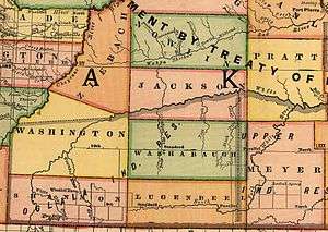 Map of Washabaugh County showing its boundaries in 1892 | |
| Coordinates: 43°33′10″N 101°41′12″W / 43.55278°N 101.68667°W | |
| Established | March 9, 1883 |
| Dissolved | January 1, 1983 |
| Area[1] | |
| • Total | 1,061 sq mi (2,750 km2) |
| Elevation | 2,713 ft (827 m) |
| Population (1970) | |
| • Total | 1,389 |
| • Density | 1.3/sq mi (0.5/km2) |
| GNIS feature ID | 1265805[2] |
Washabaugh County was a county in South Dakota. The county was named after Frank J. Washabaugh, a prominent South Dakota politician.[3][4]
History
First established in 1883 as a county in Dakota Territory from a part of Lugenbeel County, it became a county in the new state of South Dakota in 1889.[5] Washabaugh remained an unorganized county, attached to various other counties for judicial purposes, until it merged with Jackson County in 1983.[5]
Geography
The county encompassed the northeast corner of the Pine Ridge Indian Reservation including the community of Wanblee. The eastern portion of the county was within the Rosebud Indian Reservation until 1911, when that part was annexed into the newly created Mellette County.[6] By 1914, Washabaugh County's boundaries were expanded to include a portion of Washington County to the west and all of Jackson County south of the White River.[7]
Demographics
As an unorganized county lying entirely within two American Indian reservations, Washabaugh did not report separate population totals during the 1890, 1900, and 1910 censuses. Instead, population was included in the total population counts for the Pine Ridge and Rosebud reservations.[8] The county started reporting separate population counts with the 1920 Census.
| !1890 | 1900 | 1910 | 1920 | 1930 | 1940 | 1950 | 1960 | 1970 |
|---|---|---|---|---|---|---|---|---|
| [8] | [8] | [8] | 1,166 | 2,474 | 1,980 | 1,551 | 1,042 | 1,389 |
References
- ↑ United States Census Bureau (1973). 1970 Census of Population: South Dakota (PDF). Volume 1, Part 43. Government Printing Office. p. 15.
- ↑ "Washabaugh County (historical)". Geographic Names Information System. United States Geological Survey. Retrieved 2009-05-04.
- ↑ Gannett, Henry (1905). The Origin of Certain Place Names in the United States (Second ed.). Washington, D.C.: Government Printing Office. p. 316.
- ↑ Place Names in the United States at Google Books
- 1 2 John H. Long, Editor (2006). "Dakota Territory, South Dakota, and North Dakota: Individual County Chronologies". Dakota Territory Atlas of Historical County Boundaries. Newberry Library. Retrieved 2008-07-18.
- ↑ United States Census Bureau (1921). Fourteenth Census of the United States. State Compendium, South Dakota. (PDF). Government Printing Office. pp. 12, 25.
- ↑ 1914 Map of Washabaugh County
- 1 2 3 4 United States Census Bureau (1913). THIRTEENTH CENSUS OF THE UNITED STATES. (PDF). Volume 3, Population. Government Printing Office. p. 689.
- ↑ "SOUTH DAKOTA - Population of Counties by Decennial Census: 1900 to 1990". United States Census Bureau. 1995. Retrieved 2006-10-16.