Warsaw, Indiana
| Warsaw, Indiana | |
|---|---|
| City | |
| City of Warsaw | |
|
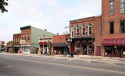
Downtown Warsaw in October 2005 | |
| Nickname(s): "Lake City", "Orthopedic Capital of the World" | |
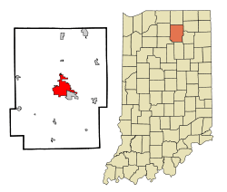 Location in the state of Indiana, USA | |
| Coordinates: 41°14′26″N 85°50′49″W / 41.24056°N 85.84694°WCoordinates: 41°14′26″N 85°50′49″W / 41.24056°N 85.84694°W | |
| Country | United States |
| State | Indiana |
| County | Kosciusko |
| Township | Plain, Wayne |
| Government | |
| • Mayor | Joseph Thallemer (R) |
| Area[1] | |
| • Total | 12.92 sq mi (33.46 km2) |
| • Land | 11.58 sq mi (29.99 km2) |
| • Water | 1.34 sq mi (3.47 km2) |
| Elevation | 827 ft (252 m) |
| Population (2010)[2] | |
| • Total | 13,559 |
| • Estimate (2012[3]) | 13,815 |
| • Density | 1,170.9/sq mi (452.1/km2) |
| Time zone | EST (UTC-5) |
| • Summer (DST) | EDT (UTC-4) |
| ZIP codes | 46580-46582 |
| Area code(s) | 574 |
| FIPS code | 18-80306[4] |
| GNIS feature ID | 0445487[5] |
| Website |
warsaw |
| Historical population | |||
|---|---|---|---|
| Census | Pop. | %± | |
| 1850 | 304 | — | |
| 1870 | 2,206 | — | |
| 1880 | 3,123 | 41.6% | |
| 1890 | 3,574 | 14.4% | |
| 1900 | 3,987 | 11.6% | |
| 1910 | 4,430 | 11.1% | |
| 1920 | 5,478 | 23.7% | |
| 1930 | 5,730 | 4.6% | |
| 1940 | 6,378 | 11.3% | |
| 1950 | 6,625 | 3.9% | |
| 1960 | 7,234 | 9.2% | |
| 1970 | 7,506 | 3.8% | |
| 1980 | 10,647 | 41.8% | |
| 1990 | 10,968 | 3.0% | |
| 2000 | 12,415 | 13.2% | |
| 2010 | 13,559 | 9.2% | |
| Est. 2015 | 14,472 | [6] | 6.7% |
| Source: US Census Bureau | |||
Warsaw is a city in and the county seat of Kosciusko County, Indiana, United States.[7] Cradled among Winona Lake, Pike Lake, Hidden Lake, and Center Lake, Warsaw has a population of 13,559 as of the 2010 U.S. Census.
Etymology
Warsaw, named after the capital of Poland in tribute to Tadeusz Kościuszko, platted on October 21, 1836.[8] The Warsaw post office was established in 1837.[9]
History
Early Warsaw contained traders, trappers, and merchants supplying manufactured goods to area farmers. Because of the central location in the lake region, tourists soon began visiting Warsaw and eventually made permanent residences in the city, with industry soon following.
In March 1854, Warsaw became a town, and the initial census on February 2, 1854 showed a total of 752 residents in the town limits. The Pennsylvania Railroad (then known as the Pittsburgh, Fort Wayne, and Chicago Railroad) reached Warsaw in November 1854. The Big Four Railroad (Cleveland, Cincinnati, Chicago, and St Louis) arrived in Warsaw in August 1870.
Gas lights were installed in August 1880. Telephone lines were strung in 1882, with Dr. Eggleston having the first phone. The waterworks were constructed in 1885. Gas was supplemented with electricity in 1897, but gas was still used in many homes until 1915.
In 1895, Revra DePuy founded DePuy Manufacturing in Warsaw to make wire mesh and wooden splints, becoming the world's first manufacturer of orthopedic appliances. In 1905, DePuy hired Justin Zimmer as a splint salesman. Zimmer broke away from DePuy in 1927 to start his own orthopedic company with Joe Ettinger in the basement of Ettinger. Warsaw is now known as the "orthopaedic capital of the world."[10][11]
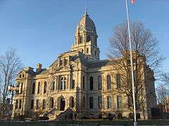
East Fort Wayne Street Historic District, Kosciusko County Jail, Warsaw Courthouse Square Historic District, Warsaw Cut Glass Company, and Justin Zimmer House are listed on the National Register of Historic Places.[12]
Geography
Warsaw is located at 41°14′26″N 85°50′49″W / 41.24056°N 85.84694°W (41.240564, -85.847002)[13] and occupies the area between Pike Lake, Hidden Lake and Center Lake (to the north) and Winona Lake (to the southeast). The Tippecanoe River passes through the West portion of Warsaw. U.S. Route 30 and Indiana State Road 15 both pass through town, while Indiana State Road 25 begins on West Market Street while traffic is routed to West Winona Avenue along with State Road 15 after US Route 30 bypassed the downtown area.
According to the 2010 census, Warsaw has a total area of 12.918 square miles (33.46 km2), of which 11.58 square miles (29.99 km2) (or 89.64%) is land and 1.338 square miles (3.47 km2) (or 10.36%) is water.[1]
Transportation
Airport
- KASW - Warsaw Municipal Airport
Demographics
2010 census
As of the 2010 U.S. Census,[2] there were 13,559 people, 5,461 households, and 3,311 families residing in the city. The population density was 1,170.9 inhabitants per square mile (452.1/km2). There were 6,066 housing units at an average density of 523.8 per square mile (202.2/km2). The racial makeup of the city was 89.5% White, 1.6% African American, 0.5% Native American, 2.2% Asian, 4.3% from other races, and 2.0% from two or more races. Hispanic or Latino of any race were 10.4% of the population.
There were 5,461 households of which 32.1% had children under the age of 18 living with them, 43.1% were married couples living together, 12.8% had a female householder with no husband present, 4.7% had a male householder with no wife present, and 39.4% were non-families. 32.8% of all households were made up of individuals and 11.7% had someone living alone who was 65 years of age or older. The average household size was 2.38 and the average family size was 3.02.
The median age in the city was 34.8 years. 25.2% of residents were under the age of 18; 9.2% were between the ages of 18 and 24; 28.2% were from 25 to 44; 24% were from 45 to 64; and 13.4% were 65 years of age or older. The gender makeup of the city was 49.1% male and 50.9% female.
2000 census
As of the 2000 U.S. Census,[4] there were 12,415 people, 4,794 households, and 3,068 families residing in the city. The population density was 1,184.6 people per square mile (457.4/km²). There were 5,101 housing units at an average density of 486.7 per square mile (187.9/km²). The racial makeup of the city was 70.50% White, 1.41% African American, 0.39% Native American, 1.07% Asian, 0.02% Pacific Islander, 5.25% from other races, and 1.37% from two or more races. Hispanic or Latino of any race were 29.21% of the population.
There were 4,794 households out of which 32.4% had children under the age of 18 living with them, 49.0% were married couples living together, 10.8% had a female householder with no husband present, and 36.0% were non-families. 30.4% of all households were made up of individuals and 11.8% had someone living alone who was 65 years of age or older. The average household size was 2.49 and the average family size was 3.11.
In the city the population was spread out with 26.0% under the age of 18, 10.9% from 18 to 24, 29.0% from 25 to 44, 21.0% from 45 to 64, and 13.2% who were 65 years of age or older. The median age was 34 years. For every 100 females there were 97.3 males. For every 100 females age 18 and over, there were 93.3 males.
The median income for a household in the city was $36,564, and the median income for a family was $45,153. Males had a median income of $33,322 versus $22,284 for females. The per capita income for the city was $19,262. About 6.8% of families and 9.2% of the population were below the poverty line, including 8.7% of those under age 18 and 13.4% of those age 65 or over.
Government
Warsaw has an elected mayor, clerk and city council-style of government. Officials are elected for four-year terms. Warsaw's current mayor is Republican Dr. Joseph Thallemer, who has served since January 1, 2012. Mike Hodges is Warsaw's longest serving mayor who served for 5 terms.
Representatives - common council
The Warsaw Common Council is a seven-member legislative group that serve four-year terms. Five of the members represent specific districts; two are elected city-wide as at-large council members.
- Jack Wilhite: At-large
- Cindy Dobbins: At-large
- Jeff Grose: 1st district
- Ron Shoemaker: 2nd district [14]
- Mike Klondaris: 3rd district & Current President of the Council
- William "Jerry" Frush: 4th district
- Diane Quance: 5th district
- Lynne Christiansen: Clerk Treasurer
Economy

Warsaw, known as the "Orthopedic Capital of the World",[15] is home to the first orthopedic device manufacturer, the DePuy Manufacturing Company, started in 1895 by Revra DePuy. Competitors, such as Zimmer, Inc. in 1927 and Biomet, Inc. in 1977, have subsequently been founded in Warsaw to support the industry. Several orthopedic suppliers are also present.
Other companies headquartered in Warsaw are Da-Lite, makers of commercial and home theater projection screens; RR Donnelley, a commercial printing press; Dalton Foundry, a malleable iron casting foundry; ABC Industries, a leader in mining ventilation products and industrial textile fabrics; Penguin Point, a regional fast-food chain; and PayLeap, a payment gateway service provider. Historically, Warsaw was home to the Biltwell Basket Company and to Explorer Van, founded by Bob Kesler.
Culture

Warsaw is home to the Wagon Wheel Theatre [16] founded in 1956 and becoming a non-profit organization in 2011 featuring a "theatre in the round".
City Parks, the Lake City Greenway Trails,[17] City County Athletic Complex (CCAC)[18] and two golf courses offer citizens recreation. Central Park, which overlooks Center Lake, is host to regular concerts during the summer months.[19]
Center Lake Park includes the Warsaw Biblical Gardens which is a noted Biblical garden.[20]
The Rotary Club of Warsaw [21] was chartered on June 1, 1919, being one of the oldest clubs in the community and part of Rotary International. residence.
Radio
WLAB, Star 88.3, broadcasts to the community, via its translator on FM radio frequency 90.9 FM.
You can also listen to the best oldies in the Lake City area on Oldies 101.1, WMYQ (WLQZ-LP), where they are "Always Playing a Better Oldie."
WRSW, "the heritage station" of the Warsaw community, broadcasts at 107.3 FM on the radio dial.
"Willie 103.5" WAWC began broadcasting in Warsaw in November 2006.
ESPN 1480 (WRSW-AM, ESPN Radio affiliate) and 102.7 The Fan (WLEG, Fox Sports Radio affiliate) are both also from Warsaw
News
Ink Free News - Up to the minute digital news source for Warsaw and the surrounding area.
Education
- Alternative Learning Center, public school · grades 9-12 · 680 students
- Charter College of Health and Massage Therapy
- Certified Natural Health Professionals · Natural Health Education and Certification
- Edgewood Middle School, public school · grades 7-8 · 887 students
- Eisenhower Elementary School, public school · grades K-6 · 523 students
- Grace College - Warsaw Campus
- Harrison Elementary School, public school . grades K-6 . 611 students
- Indiana Tech - Warsaw Campus
- Ivy Tech Community College - North Central Campus
- Lakeland Christian Academy, private school · grades 7-12 · 170 students
- Lakeview Middle School, public school · grades 7-8 · 760 students
- Lighthouse Christian Academy, private school · grades Pre K-12 454 students
- Lincoln Elementary School, public school · grades K-6 · 456 students
- Living Stone's Preparatory School, private school · grades Pre K-12
- Madison Elementary School, public school · grades K-6 · 563 students
- Monarch Christian Academy, private School · grades K-12 · 23 students
- Sacred Heart School, private school · grades Pre K-6 · 206 students
- Trinity School of Natural Health · Distance Learning Natural Health Education
- Warsaw Christian School, private school · grades Pre K-6 · 240 students
- Warsaw Community High School, public school · grades 9-12 · 1,947 students[22]
- Washington STEM Academy, public school · grades K-6 · 555 students[23]
Notable people
- Bubba the Love Sponge, radio host and party to Hulk Hogan lawsuit versus Gawker.
- Ambrose Bierce, author of The Devil's Dictionary.
- Howard Brubaker, magazine editor and writer
- Theodore Dreiser, author of Sister Carrie and An American Tragedy; in 1935, his books were burned by the local library.
- Jesse E. Eschbach, United States jurist
- David C. Fisher, author, pastor
- Rick Fox, actor and former NBA basketball player who was discovered by Grace College coach Jim Kessler on a missions trip to the Bahamas and played basketball at Warsaw Community High School for Coach Al Rhodes during the 1984-1985 and 1985-1986 seasons. Played for the University of North Carolina men's basketball team.
- Ben Higgins, contestant on season 11 of The Bachelorette, star of season 20 of The Bachelor.
- Mike Hodges, Five-Time Mayor of Warsaw
- Steve Hollar, actor who played Rade Butcher, one of the Hickory Huskers, in Hoosiers. Now a dentist in Warsaw.
- Merlin Hull, United States Representative from Wisconsin.
- Gary Kosins, NFL player
- Hal Kratzsch, an original member of famed singing group The Four Freshmen.
- James R. Leininger, physician, founder of Kinetic Concepts
- Tom Metzger, an American white supremacist who founded the White Aryan Resistance group.
- Marshall Plumlee, Plays for the Duke Blue Devils Men's Basketball team.
- Mason Plumlee, Played for the Duke Blue Devils Men's Basketball team and was a consensus 2013 Second Team All-American. Drafted in the first round of the 2013 NBA Draft by the Brooklyn Nets. Currently plays for Portland Trailblazers
- Miles Plumlee, NBA basketball player Played for the Duke Blue Devils Men's Basketball team and was drafted in the first round of the 2012 NBA Draft as a power forward/center by the Indiana Pacers, currently plays for the Milwaukee Bucks.
- Alyson Charles, Global Television Host, Shamanic Practitioner, Wellness Expert and Explorer.
- Kenneth "Shutter" Riordan, Development Engineer, Zimmer, Inc
In popular culture
- Warsaw is featured in the 2006 video game, Splinter Cell: Essentials.
- The 2008 documentary American Teen was filmed in Warsaw.
- Warsaw is mentioned in the 4th season of the HBO Show Boardwalk Empire
- Warsaw is mentioned in the 2011 film "I Am Number Four".
- Warsaw is the hometown of The Bachelor Season 20's Ben Higgins.
References
- 1 2 "G001 - Geographic Identifiers - 2010 Census Summary File 1". United States Census Bureau. Retrieved 2015-07-29.
- 1 2 "American FactFinder". United States Census Bureau. Retrieved 2012-12-11.
- ↑ "Population Estimates". United States Census Bureau. Retrieved 2013-06-25.
- 1 2 "American FactFinder". United States Census Bureau. Retrieved 2008-01-31.
- ↑ "US Board on Geographic Names". United States Geological Survey. 2007-10-25. Retrieved 2008-01-31.
- ↑ "Annual Estimates of the Resident Population for Incorporated Places: April 1, 2010 to July 1, 2015". Retrieved July 2, 2016.
- ↑ "Find a County". National Association of Counties. Retrieved 2011-06-07.
- ↑ Biographical and Historical Record of Kosciusko County, Indiana. Lewis Publishing Company. 1887. p. 689.
- ↑ "Kosciusko County". Jim Forte Postal History. Retrieved 25 November 2014.
- ↑ "Warsaw History" http://www.warsaw.in.gov/index.aspx?NID=216 Retrieved 2015-02-14
- ↑ The Wall Street Journal Classroom Edition
- ↑ National Park Service (2010-07-09). "National Register Information System". National Register of Historic Places. National Park Service.
- ↑ "US Gazetteer files: 2010, 2000, and 1990". United States Census Bureau. 2011-02-12. Retrieved 2011-04-23.
- ↑ http://www.southbendtribune.com/news/publicsafety/four-men-from-warsaw-killed-in-south-carolina-plane-crash/article_e390df38-6978-11e5-b7f1-3b1e7147eb7b.html
- ↑ OrthoWorx http://orthoworxindiana.com/about-us/the-orthopedic-capital-of-the-world/ Retrieved 2015-02-14
- ↑ "Wagon Wheel Theatre" http://www.wagonwheeltheatre.org/ Retrieved 2015-02-14
- ↑ http://www.warsaw.in.gov/index.aspx?NID=252
- ↑ http://www.ccacwarsaw.com
- ↑ http://www.warsaw.in.gov/index.aspx?NID=201
- ↑ "Warsaw Biblical Gardens" http://www.warsawbiblicalgardens.org/ Retrieved 2015-02-14
- ↑ "Warsaw Rotary Club" http://www.warsawrotary.com/ Retrieved 2015-02-14
- ↑ "Warsaw Community High School" http://wchs.warsaw.k12.in.us/ Retrieved 2015-02-14
- ↑ "Washington STEM Academy". http://washington.warsaw.k12.in.us/. External link in
|website=(help);
External links
- Up-to-date information and events on Warsaw, Indiana from Orthoworx
- City of Warsaw, Indiana website
- Official Kosciusko County Visitors Bureau
- Warsaw Community Public Library
- Warsaw Times-Union Newspaper
- City-County Athletic Complex
- Video from CBS Early Show episode spotlighting Warsaw
- Dreiser, Theodore (1916). "Chapt. 35, Warsaw at Last! & Chapt. 36, Warsaw in 1884-6". A Hoosier Holiday. New York: John Lane Co. pp. 283–297.
Municipalities and communities of Kosciusko County, Indiana, United States | ||
|---|---|---|
| Cities | ||
| Towns | ||
| Townships | ||
| Unincorporated communities |
| |
| Footnotes | ‡This populated place also has portions in an adjacent county or counties | |
