Wardha
| Wardha वर्धा पालकवाडी | |
|---|---|
| city | |
 Wardha Location in Maharashtra, India | |
| Coordinates: 20°44′30″N 78°36′20″E / 20.74167°N 78.60556°ECoordinates: 20°44′30″N 78°36′20″E / 20.74167°N 78.60556°E | |
| Country |
|
| State | Maharashtra |
| District | Wardha |
| Elevation | 234 m (768 ft) |
| Population (2011)[1] | |
| • Total | 106,444 |
| Languages | |
| • Official | Marathi |
| Time zone | IST (UTC+5:30) |
| Website |
www |
Wardha ![]() pronunciation (Marathi: वर्धा) is a city and a municipal council in Wardha district in the Indian state of Maharashtra. It is the administrative headquarters of Wardha district. Wardha gets its name from the Wardha River which flows at the North, West and South boundaries of district. Founded in 1866, the town is now an important centre for the cotton trade. It was an important part of Gandhian Era.
pronunciation (Marathi: वर्धा) is a city and a municipal council in Wardha district in the Indian state of Maharashtra. It is the administrative headquarters of Wardha district. Wardha gets its name from the Wardha River which flows at the North, West and South boundaries of district. Founded in 1866, the town is now an important centre for the cotton trade. It was an important part of Gandhian Era.
Geography and Climate
Wardha is located at 20°45′N 78°36′E / 20.75°N 78.60°E.[2] It has an average elevation of 234 metres (767 feet).
| Climate data for Wardha (1971–2000) | |||||||||||||
|---|---|---|---|---|---|---|---|---|---|---|---|---|---|
| Month | Jan | Feb | Mar | Apr | May | Jun | Jul | Aug | Sep | Oct | Nov | Dec | Year |
| Record high °C (°F) | 35.0 (95) |
41.8 (107.2) |
43.9 (111) |
46.4 (115.5) |
48.4 (119.1) |
47.1 (116.8) |
41.4 (106.5) |
39.7 (103.5) |
37.9 (100.2) |
38.7 (101.7) |
36.4 (97.5) |
33.4 (92.1) |
48.4 (119.1) |
| Average high °C (°F) | 28.7 (83.7) |
31.4 (88.5) |
36.4 (97.5) |
41.1 (106) |
42.8 (109) |
36.9 (98.4) |
31.6 (88.9) |
30.2 (86.4) |
31.6 (88.9) |
32.6 (90.7) |
30.2 (86.4) |
28.7 (83.7) |
33.3 (91.9) |
| Average low °C (°F) | 13.9 (57) |
16.0 (60.8) |
19.9 (67.8) |
24.5 (76.1) |
27.5 (81.5) |
25.3 (77.5) |
23.3 (73.9) |
22.8 (73) |
22.5 (72.5) |
20.6 (69.1) |
17.2 (63) |
13.8 (56.8) |
20.5 (68.9) |
| Record low °C (°F) | 6.7 (44.1) |
7.4 (45.3) |
7.4 (45.3) |
15.9 (60.6) |
16.9 (62.4) |
13.9 (57) |
14.9 (58.8) |
12.9 (55.2) |
16.5 (61.7) |
10.5 (50.9) |
8.6 (47.5) |
6.2 (43.2) |
6.2 (43.2) |
| Average rainfall mm (inches) | 16.7 (0.657) |
14.9 (0.587) |
9.9 (0.39) |
6.4 (0.252) |
11.4 (0.449) |
176.9 (6.965) |
284.1 (11.185) |
275.0 (10.827) |
162.8 (6.409) |
74.7 (2.941) |
14.9 (0.587) |
17.2 (0.677) |
1,065 (41.929) |
| Average rainy days | 0.9 | 1.0 | 0.9 | 0.8 | 1.3 | 8.9 | 13.6 | 12.0 | 9.7 | 3.7 | 0.7 | 1.1 | 54.6 |
| Source: India Meteorological Department [3][4] | |||||||||||||
Demographics
Wardha city is administered by a municipal council(category-A). According to census 2011, its population is nearly 105,543.[5] But this figure is number of inhabitants within municipal boundaries. Urbanization has crossed municipal boundaries and neighboring villages viz. sindi(meghe), sawangi(meghe), borgaon(meghe), pipri(meghe),mhasala, nalwadi and chitoda have become part of urban agglomeration having population nearing 2 lacs.
As of 2011 India census,[6] Wardha district had a population of 1,296,157[7] Males constitute 52% of the population and females 48%. Wardha has an average literacy rate of 80%, higher than the national average of 59.5%: male literacy is 83%, and female literacy is 76%. In Wardha, 11% of the population is under 6 years of age. Wardha is the largest city in wardha district.
History
It was included in the empire of the Mauryas, Shungas, Satavahanas and Vakatakas. Pravarapura, modern Pavnar, was once the capital of the Vakataka dynasty. Vakatakas were contemporary of Imperial Guptas. Prabhavatigupta, the daughter of Chandragupta II (Vikramaditya), was married with Vakataka ruler Rudrasena. The period of Vakatakas was 2nd to 5th century CE. The empire stretched from the Arabian sea in the west to the Bay of Bengal in the east, and from the Narmada river in the north to the Krishna-Godavari delta in south.
Later on, Wardha was ruled by the Chalukyas, Rashtrakutas, Yadavas, the Delhi Sultanate, the Bahamani Sultanate, Muslim ruler of Berar, Gonds and Marathas. Raja Buland Shaha of Gonds, Raghuji of Bhonsale were the prominent rulers in the Medieval period.
During the 1850s Wardha, (then a part of Nagpur) fell into the hands of British. They included Wardha in the Central Provenance.
Wardha is a sister city for Sevagram, and both were used as major centers for the Indian Independence Movement, especially as headquarters for an annual meet of the Indian National Congress in 1934, and Mahatma Gandhi's Ashram.
The existing Wardha district was part of Nagpur district till 1862. Further it was separated for convenient administrative purposes and Kawatha near Pulgaon was the district headquarters. In 1866, the district headquarters moved at Palakwadi village. The huts in village were destroyed and new city was constructed by English town-planner Sir Bachlor and Crawdok. This new city was given name "Wardha". In Wardha district there is a village called Pavanar where Acharya Vinoba Bhave lived.
Transport
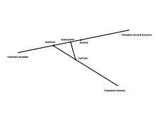
Wardha city is well connected to most of the parts of India by railways. Wardha city has two railway stations i.e. Wardha and Sewagram railway stations. Wardha railway station is an important rail junction on Howrah-Nagpur-Mumbai line. This town is also connected to southern part of country through Sevagram station. After Nagpur, Wardha is only city through which Delhi-Chennai and Mumbai-Kolkata railway routes pass, actually meet together. Traffic on Mumbai-Kolkata route is mainly dealt with at Wardha station and traffic on Delhi-Chennai route is dealt with at Sewagram station (former Wardha East station).
A new line joining Wardha to Nanded via Yavatmal, pusad, deoli etc. is being constructed. A new fifth platform is proposed to deal with increased passenger traffic. Both Delhi-Chennai and Mumbai-Kolkata railway routes are already having heavy traffic and both routes get combined between Sewagram and Nagpur stations. A new third line is under construction between Sewagram and Nagpur stations to cater for heavy traffic. Sewagram station is having five platforms.
On outskirts of city there are two more railway stations, i.e. Warud station (former Sewagram station) and Chitoda junction, which deal with local passenger traffic. Chitoda junction is situated on southbound lines from Wardha and Sewagram stations. Warud station is halt station near doctor colony at Sewagram.
Wardha city is equally well connected by roads to other cities of maharashtra. A newly declared National Highway No.361(Nagpur-Wardha-Yavatmal-Nanded-Latur-Tuljapur) pass through this city. Also Nagpur-Aurangabad-Mumbai Express Highway pass through it.
The Dr. Babasaheb Ambedkar International Airport at Nagpur is the nearest airport with scheduled air services.
Religion and culture
Population of Wardha city constitutes Hindus, Muslims and Buddhists with little percentage of Christians, Jains and Sikhs. Main spoken languages are Marathi and Hindi. Other languages viz. Marwari,Gujarati, Sindhi and Punjabi are spoken by people of respective communities. There are many temples, mosques, viharas, gurudwaras, jain temples and churches of which Laxminarayan temple (Bachchhraj road), Lingi Mandir (Mahadeo Mandir)near Dr. Raosaheb Gade Bhavan, Vitthal mandir (hawaldwarpura), Ganesh Mandir (Main Road), Gajanan Maharaj Mandir, Sai mandir (M.G. Road), Digambar and Shwetambar Jain temples (mahadeopura),Jama Masjid (Itwara), Shanti Stupa (Gopuri), Gurudwara (Samtanagar) are important. There is a church named St. Thomas church in Wardha which was built by the British. St. Thomas is the property of Church of England. It was handed to Church of India in 1874. CNI church Wardha is the main church which was a Presbyterian church before the formation of Church of North India in 1970. CNI established Christ Church in Sewagram.
Marathi Sahitya Sammelan, the conference on Marathi Literature were held once in Wardha city. It was presided by President of the Conference Purushottam Shivram Rege in 1969.
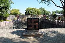
Wardha was one of the pre-planned cities of British India. The town-planners were Sir Crowdock and Bachelor. In memory of Sir Crowdock, his name was given to district's biggest school and an important road was named after Sir Bachelor in British perios. The Crowdock school was renamed as Mahatma Gandhi. Still old name was in vogue till a decade ago. District Hospital had name King George and it was renamed later on. But the stone carved with old name was at main gate for more than century. It was hidden by new name board of District Hospital. There are many buildings of British period in city which include Z.P. old building, Central Jail, Church at Bajajwadi, cemetery etc.
Education
Wardha city is famous for a number of educations institutions. Some of the notable institutes are Mahatma Gandhi Institute of Medical Sciences (MGIMS) at Sewagram, Bapurao Deshmukh College of Engineering(BDCE) (http://www.bdce.edu.in) at Sewagram,Jawaharlal Nehru Medical College (along with Dental college, Physiotherapy college, Nurses training college) at Sawangi, Ayurvedic medical college at Salod, Rashtrabhasha Prachar Samiti at Wardha,Priyadarshini Mahila Mahavidyalaya,Wardha(www.pmm.ac.in) and Janakidevi Bajaj College of Science at Wardha. There are six engineering colleges in Wardha, namely Bapurao Deshmukh, Sureshrao Deshmukh, Om, Acharya Vinoba Bhave, Datta Meghe and Agnihotri College of Engineering.The Institute Of Pharmaceuticals Education and Research is a reputed pharmacy college in Wardha.
Mahatma Gandhi Institute of Medical Sciences is one of the top rated institutes of India. It is an autonomous university and conducts its own admission test. Students all over India dream of getting admission here.
Another jewel of Wardha is Mahatma Gandhi Antarrashtriya Hindi Vishwavidyalaya which is World's only international Hindi University. Mahatma Gandhi Antarrashtriya Hindi Vishwavidyalaya (Mahatma Gandhi International Hindi University) is established by the Parliament of India and run directly by the Government of India. Its chancellor is President of India. It has students all over world.
New English High School, Wardha is one of the oldest school with a very big playground. This school has given many scholars from Wardha to the society. School Of Scholars also gave many scholars one of which is Ma.Shlok Rajesh Ingle Son Of Mr.Rajesh Ingle and Mrs.Vaishali Ingle. ,Alphonsa High School,Agragami High School,Bharat Dnyan Mandiram convent and Bhavan's Lloyds Vidya Niketan, are the English-medium CBSE schools in Wardha. Kasturba Vidya Mandir is one of the oldest school run by Kasturba Society affiliated to Mahatma Gandhi Institute of Medical Sciences .
Important places
Magan Sangrahalaya (museum)
This museum was inaugurated by Mahatma Gandhi in 1938. It is situated in Maganwadi near the village's Centre of Science. The purpose of construction of this museum is to spread awareness about research and development of rural industries, agriculture, dairy, various types of charkhas, khadi, hadicrafts by rural artisans, methods to promote Swadeshi movement, magandeep hkhadi bhandar, sele khadi gramodyog khadi cloth and gramodyog products gandhi charkha sample etc.
Gitai Mandir
This temple is situated in Gopuri near Vishwa Shanti Stupa. This is a unique temple in India which has no deity and roof. It has just walls made of granite slabs on which 18 chapters of Gitai (Shrimad-bhagwad-gita in marathi) are inscribed. The walls enclose a little beautiful park. This temple was inaugurated by Acharya Vinoba Bhave in 1980. Beside are two exhibitions about life of Acharya Vinoba Bhave and Jamnalal Bajaj.
Vishwa Shanti Stupa
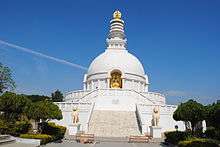
Vishwa Shanti Stupa was a dream of Fujii guruji as called by Gandhi. It is beside Gitai Mandir. It is a large stupa of white color. Statues of Buddha are mounted on stupa in four directions. It also has a small Japanese Buddhist temple with a large park.There is a temple near the stupa where prayers are done for universal peace. It is one of many Peace Pagoda's which have been built around the world.
Sevagram Ashram
See Sevagram
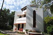
Sevagram ashram was the residence of Mahatma Gandhi from 1936 to 1948. After his 1930 Dandi salt march, Gandhi decided not to return to his ashram at Sabarmati. After spending two years in jail, he travelled around India and, at the invitation of the Gandhian industrialist Jamnalal Bajaj., stayed for some time in Wardha City at Jamnalal's bungalow.[8] In 1936, at the age of 67, Gandhiji moved to a village (which he subsequently called Sewagram - Hindi for village of service) at the outskirts of Wardha and started to live here in a group of huts with his wife Kasturba and other disciples. This slowly grew into an ashram, where Gandhi lived with his followers for the next twelve years, till his death. The premises are very calming. Many personal items used by Gandhi and his contemporaries are preserved here including his spectacles, telephone, notebook, tables, mats, etc.[9]
Paramdham Ashram
This ashram was established by Acharya Vinoba Bhave in 1934 at Pawnar on bank of river Dham with spiritual purpose. He also establish Brahma Vidya mandir in it. He started Bhoodan Movement from here. Also starting point of "Bharat Chhodo Andolan" was this ashram. Pawnar is an ancient city dating back to Mahabharata. During Bhonsle reign Pawnar was vidarbha's most important military station. During excavation for construction of ashram, many sculptures and idols were found which are kept at ashram and open to visitors.
Rashtrbhasha Prachar Samiti
Rashtrabhasha Prachar Samiti is devoted institute for spreading Hindi all over world. It has branches all over world, but its headquarters is at Wardha.
Kelzar Ganpati temple
The Kelzar Ganpati Temple is situated about 26 km from Wardha on the Nagpur road. This temple is situated on a hill & surrounded by the scenic beauty of forests & hills. The temple is historical place and its history goes back to "Vashishtha Purana". The temple is situated near the Bor National Tiger Reserve & Bird sanctuary.
The place is also mentioned in "Mahabharata" as Ekchakranagari. According to myth,Pandavas lived here during agyatvas. Bhima killed Bakasura at this place and threw down this hill. An ancient cave where Bakasura is still at foot of the hill and his famous well is also nearby. This well has sculptured stones on inner wall and stairs. Remains of old fort are also seen here. Finding sculptures during digging for any purpose is common. Sculptures relating to hinduism, jainism and buddhism has found. But ASI is not paying attention to this. Many sculptures have ruined due to proper lack of care. Some sculptures can be seen in above temple, nearby hillock, gram panchayar office buddha vihar and emerging Angel's Paradise English Medium School with huge campus and all facility for students with modern teaching techniques.
Agriculture
Wardha is primarily an agriculture oriented city. Cotton farming and Soybean cultivation in Kharif is quite common. Government has provided canals to irrigate during Rabi season when Bengal Gram becomes a popular choice to sow.
Many institutions are encouraging farmers to go natural or organic but the lack of support systems either in availability of techniques and marketability of produce is preventing the spread of this movement.
Industries
Very silently Wardha is becoming second industrial hub of Vidarbha area. This is due to its geographical location and very well rail and road connectivity. A decade ago, it was industrially backward. But last decade witnessed many companies, industrial plants landing & establishing here. Some of them are Uttam Galva metallics ltd., Uttam value steels ltd (Previously Lloyds Steel Industries ltd), Indraprastha power plant, Lanco power plant(Mandwa), mahalaxmi steel plant, Gammon industries, Powergrid's largest station.
Information Technology
Wardha IT park of C. Dass group is second in the Vidarbha region after Nagpur in terms of IT park. It is located at MIDC area on Wardha-Sevagram road.
See also
References
- ↑ http://www.censusindia.gov.in/pca/SearchDetails.aspx?Id=558544
- ↑ Wardha District at a Glance. Wardha.nic.in. Retrieved on 2013-05-04.
- ↑ "Ahmedabad Climatological Table Period: 1971–2000". India Meteorological Department. Retrieved April 18, 2016.
- ↑ "Ever recorded Maximum and minimum temperatures up to 2010". India Meteorological Department. Archived from the original on May 21, 2013. Retrieved April 18, 2016.
- ↑ Wardha City Population Census 2011 | Maharashtra. Census2011.co.in. Retrieved on 2013-05-04.
- ↑ "Census of India 2001: Data from the 2001 Census, including cities, villages and towns (Provisional)". Census Commission of India. Archived from the original on 2004-06-16. Retrieved 2008-11-01.
- ↑ Wardha District Population Census 2011, Maharashtra literacy sex ratio and density. Census2011.co.in. Retrieved on 2013-05-04.
- ↑ Desai, Mahadev (1968). Day-to-day with Gandhi: Secretary's Diary. Mahadev Haribhai Desai.
- ↑ "The history of Sewagram". http://www.gandhiashramsevagram.org/. The Gandhi Ashram, Sevagram (Official website). Retrieved 17 June 2014. External link in
|website=(help)
External links
Wardha district topics | ||
|---|---|---|
| History | 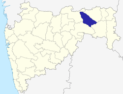 | |
| Geography | ||
| Cities and towns | ||
| Education | ||
| Transport | ||
| Lok Sabha constituencies | ||
| Vidhan Sabha constituencies | ||