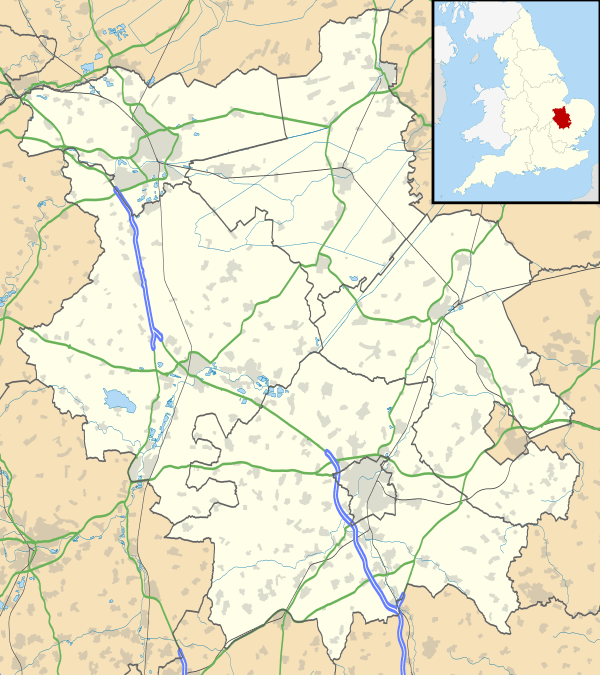
Warboys
| Warboys | |
 Warboys |
|
| Population | 3,994 (2011) |
|---|---|
| OS grid reference | TL315797 |
| District | Huntingdonshire |
| Shire county | Cambridgeshire |
| Region | East |
| Country | England |
| Sovereign state | United Kingdom |
| Post town | Huntingdon |
| Postcode district | PE28 |
| EU Parliament | East of England |
|
|
Coordinates: 52°24′N 0°04′W / 52.4°N 0.07°W
.jpg)
.jpg)
Warboys is a large village and civil parish in Cambridgeshire, England.[1] Warboys lies approximately 7 miles (11 km) north-east of Huntingdon, near Ramsey. Warboys is situated within Huntingdonshire which is a non-metropolitan district of Cambridgeshire as well as being a historic county of England.
History
Warboys is a large parish and village on what was the eastern side of Huntingdonshire bordering on Cambridgeshire.
In 1085 William the Conqueror ordered that a survey should be carried out across his kingdom to discover who owned which parts and what it was worth. The survey took place in 1086 and the results were recorded in what, since the 12th century, has become known as the Domesday Book. Starting with the king himself, for each landholder within a county there is a list of their estates or manors; and, for each manor, there is a summary of the resources of the manor, the amount of annual rent that was collected by the lord of the manor both in 1066 and in 1086, together with the taxable value.[2]
Warboys was listed in the Domesday Book in the Hundred of Hurstingstone in Huntingdonshire; the name of the settlement was written as Wardebusc in the Domesday Book.[3] In 1086 there was just one manor at Warboys; the annual rent paid to the lord of the manor in 1066 had been £12 and the rent was the same in 1086.[4]
The Domesday Book does not explicitly detail the population of a place but it records that there were 48 households at Warboys.[4] There is no consensus about the average size of a household at that time; estimates range from 3. 5 to 5. 0 people per household.[5] Using these figures then an estimate of the population of Warboys in 1086 is that it was within the range of 168 and 240 people.
The Domesday Book uses a number of units of measure for areas of land that are now unfamiliar terms, such as hides and ploughlands. In different parts of the country, these were terms for the area of land that a team of eight oxen could plough in a single season and are equivalent to 120 acres (49 hectares); this was the amount of land that was considered to be sufficient to support a single family. By 1086, the hide had become a unit of tax assessment rather than an actual land area; a hide was the amount of land that could be assessed as £1 for tax purposes. The survey records that there were nineteen ploughlands at Warboys in 1086 and that there was the capacity for a further ploughland.[4] In addition to the arable land, there was 3 acres (1 hectare) of meadows and 3,784 acres (1,531 hectares) of woodland at Warboys.[4]
The tax assessment in the Domesday Book was known as geld or danegeld and was a type of land-tax based on the hide or ploughland. It was originally a way of collecting a tribute to pay off the Danes when they attacked England, and was only levied when necessary. Following the Norman Conquest, the geld was used to raise money for the King and to pay for continental wars; by 1130, the geld was being collected annually. Having determined the value of a manor's land and other assets, a tax of so many shillings and pence per pound of value would be levied on the land holder. While this was typically two shillings in the pound the amount did vary; for example, in 1084 it was as high as six shillings in the pound. For the manor at Warboys the total tax assessed was ten geld.[4]
By 1086 there was already a church and a priest at Warboys and it was amongst the lands of the Abbey of St. Benedict at Ramsey.
The north-east part is fenland, with the higher land to the south composed of stiff clay. The land falls from about 114 feet (35 m) above sea-level in the south to 2 feet (1 m) in the fenland of the north and north-east. Nearly 3/4 of the area is arable upon which potatoes are largely grown, and also corn and beans, etc. Warboys Wood is the only remaining piece of woodland.
The village lies on high ground in the south-west part of the parish overlooking the fen to the north-east. It has grown up at the foot of a fork formed at the junction of the main road from St. Ives to Ramsey, with a branch road leading eastwards over Warboys Heath on to Fenton. The main road, as it passes through the village, is called Church Street, and the branch road is High Street. The church is at the south end of the village. There are three or four old cottages in the village, including the White Hart Inn on the north side of the High Street – a 17th-century brick house with a thatched roof. In 1996 an electrical fault caused the roof to catch fire, destroying the top storey of the building. The pub was rebuilt and opened again in 1997.[6]
In 1774 an Act of Parliament was passed for draining certain lands in Warboys, including 300 acres (121 ha) called High Fen and 60 acres (24 ha) part of New Pasture. In 1795, an Act was passed for dividing, enclosing and draining the open common fields in Warboys. A further Act was passed in 1798 to amend the previous Act as regards the lands allotted in lieu of tithes.
A local landmark is the clock tower, built in 1887 to celebrate the Golden Jubilee of Queen Victoria on the throne. Warboys is also famous for the trial of the so-called "Witches of Warboys". Much witch related iconography can be found in the village, including part of the emblem of the local primary school.
The village was one of two sites in Huntingdonshire included in the Survey of English Dialects (SED). The other was Kimbolton.[7] The traditional dialect of Warboys recorded in the SED was characterised by a 'Canadian raising' type alternation in the vowel of the PRICE lexical set.[8]
RAF Warboys
In World War II, the RAF operated a bomber airfield just south west of the village called RAF Warboys. Wellingtons operated there from 1942 until early 1943 when they were replaced by Lancasters. After early 1944, the airfield was used for training until flying operations ended late in 1945. All the buildings and land were sold by 1964.[9]
Government
As a civil parish, Warboys has a parish council. The parish council is elected by the residents of the parish who have registered on the electoral roll; the parish council is the lowest tier of government in England. A parish council is responsible for providing and maintaining a variety of local services including allotments and a cemetery; grass cutting and tree planting within public open spaces such as a village green or playing fields. The parish council reviews all planning applications that might affect the parish and makes recommendations to Huntingdonshire District Council, which is the local planning authority for the parish. The parish council also represents the views of the parish on issues such as local transport, policing and the environment. The parish council raises its own tax to pay for these services, known as the parish precept, which is collected as part of the Council Tax. The parish council consists of fifteen elected councillors and has a parish clerk.[10] The parish precept for the financial year ending 31 March 2015 was £86, 140.[11]
Warboys was in the historic and administrative county of Huntingdonshire until 1965. From 1965, the village was part of the new administrative county of Huntingdon and Peterborough. Then in 1974, following the Local Government Act 1972, Warboys became a part of the county of Cambridgeshire.
The second tier of local government is Huntingdonshire District Council which is a non-metropolitan district of Cambridgeshire and has its headquarters in Huntingdon. Huntingdonshire District Council has 52 councillors representing 29 district wards.[12] Huntingdonshire District Council collects the council tax, and provides services such as building regulations, local planning, environmental health, leisure and tourism.[13] Warboys is a part of the district ward of Warboys and Bury and is represented on the district council by two councillors.[14][12] District councillors serve for four-year terms following elections to Huntingdonshire District Council.
For Warboys the highest tier of local government is Cambridgeshire County Council which has administration buildings in Cambridge. The county council provides county-wide services such as major road infrastructure, fire and rescue, education, social services, libraries and heritage services.[15] Cambridgeshire County Council consists of 69 councillors representing 60 electoral divisions.[16] Warboys is part of the electoral division of Warboys and Upwood[14] and is represented on the county council by one councillor.[16]
At Westminster Warboys is in the parliamentary constituency of North West Cambridgeshire,[14] and elects one Member of Parliament (MP) by the first past the post system of election. Warboys is represented in the House of Commons by Shailesh Vara (Conservative). Shailesh Vara has represented the constituency since 2005. The previous member of parliament was Brian Mawhinney (Conservative) who represented the constituency between 1997 and 2005. For the European Parliament Warboys is part of the East of England constituency which elects seven MEPs using the d'Hondt method of party-list proportional representation.
Demography
Population
In the period 1801 to 1901 the population of Warboys was recorded every ten years by the UK census. During this time the population was in the range of 943 (the lowest was in 1801) and 1996 (the highest was in 1851).[17]
From 1901, a census was taken every ten years with the exception of 1941 (due to the Second World War).
| Parish |
1911 |
1921 |
1931 |
1951 |
1961 |
1971 |
1981 |
1991 |
2001 |
2011 |
|---|---|---|---|---|---|---|---|---|---|---|
| Warboys | 1790 | 1720 | 1593 | 1909 | 1950 | 1923 | 2878 | 3096 | 3866 | 3994 |
All population census figures from report Historic Census figures Cambridgeshire to 2011 by Cambridgeshire Insight.[17]
In 2011, the parish covered an area of 9,046 acres (3,661 hectares)[17] and the population density of Warboys in 2011 was 282. 6 persons per square mile (109. 1 per square kilometre).
Culture and community
Warboys Youth Action
Warboys Youth Action is a charity established in 1993 and exists to promote the moral, physical and spiritual well being of those between 11 and 18 years of age who live in the parish. With a reputation as the provider of a youth club which was housed in part of the old school at the rear of the library. The Youthie building is not currently being used due to building subsidence. The future of the Youthie building is currently under discussion.
Religious sites
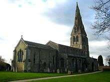
The church of St Mary Magdalene, formerly of the Blessed Mary the Virgin, consists of a chancel, nave, north aisle, south aisle, west tower, north and south porches.
Nothing now remains of the church which existed as the time of the Domesday survey of 1086. The earliest church of which there is now evidence was built in the middle of the 12th century, probably when the church and its possessions were granted by Abbot Walter to the almonry of Ramsey Abbey. This church consisted of the present nave and a north aisle. The chancel arch, the responds at each end of the north aisle and a small piece of walling at the south-west corner of the nave of this church still survive.
Early in the 13th century, the Norman north aisle, with the arcade, was rebuilt and immediately after, the south aisle with its arcade was added. In the middle of the 13th century the west tower, with its broached spire of ashlar, was built, and it was evidently intended at this date to extend the aisles westwards to the line of the west wall of the tower. If this intention was then carried out, the south extension was rebuilt in the latter part of the 14th century when the south porch was added. The north extension was also rebuilt in the early part of the 15th century when the north porch was added.
The chancel was rebuilt and shortened before the beginning of the 19th century and, in 1832, it was extended eastwards apparently to its original length and considerably altered. At this date large galleries were erected in both aisles and the tower, the floor being lowered a foot to give headroom under them. The east wall above the chancel arch, and west wall of the tower, were cased in lath and plaster, a vestry was formed at the west end of the north aisle, all the walls were coated with thick plaster and wooden mouldings fixed below the clearstory window and in other places. The spire was restored in 1898 and in 1926 the tower and south aisle were underpinned. The additions of 1832 (except those to the chancel) were removed and the floor restored to its former level.
From 2008 to 2010 further reordering took place with the interior to assist the worship to be more flexible and to give more opportunity for the building to be more versatile and comfortable. The 1927 pews were removed to be replaced by moveable chairs, the organ was overhauled and restored and moved to a new location to the west of the south door. A raised platform was installed in front of the chancel steps. The font was moved form the central location of the aisle to a position to the east of the south door. The chancel saw some changes with the front choristers book rests being relocated to become the communion rail in front of the altar and the front choristers benches replaced by chairs. The 1927 electric heating was replaced by gas central heating, and the front of the building carpeted.
Sport and leisure
Warboys has a Non-League football club Warboys Town F.C. who play at Forge Way.
Notes
- ↑ Ordnance Survey: Landranger map sheet 142 Peterborough (Market Deeping & Chatteris) (Map). Ordnance Survey. 2012. ISBN 9780319229248.
- ↑ Dr Ann Williams, Professor G.H. Martin, eds. (1992). Domesday Book: A Complete Translation. London: Penguin Books. pp. 551–561. ISBN 0-141-00523-8.
- ↑ Dr Ann Williams, Professor G.H. Martin, eds. (1992). Domesday Book: A Complete Translation. London: Penguin Books. p. 1419. ISBN 0-141-00523-8.
- 1 2 3 4 5 Professor J.J.N. Palmer, University of Hull. "Open Domesday: Place – Warboys". www. opendomesday.org. Anna Powell-Smith. Retrieved 25 February 2016.
- ↑ Goose, Nigel; Hinde, Andrew. "Estimating Local Population Sizes" (PDF). Retrieved 23 February 2016.
- ↑ "Friends of Warboys Library Historical Pictures".
- ↑ Orton, H. and Tilling, P. (1969) Survey of English Dialects (B) The Basic Materials. Volume III The East Midland Counties and East Anglia. Leeds: E. J. Arnold and Sons.
- ↑ Britain, D. (1997) "Dialect Contact and Phonological Reallocation: 'Canadian Raising' in the English Fens". Language in Society 26/1, 15–46; Wells, J. (1982) Accents of English. Cambridge: Cambridge University Press.
- ↑ "Bomber Command Warboys". RAF. Retrieved 6 November 2007.
- ↑ "Warboys Parish Council: Councillors". www. warboyspc.info. Warboys Parish Council. Retrieved 9 February 2016.
- ↑ "Warboys Parish Council: Annual Return 2014–15". www. warboyspc.info. Warboys Parish Council. Retrieved 9 February 2016.
- 1 2 "Huntingdonshire District Council: Councillors". www. huntingdonshire.gov.uk. Huntingdonshire District Council. Retrieved 23 February 2016.
- ↑ "Huntingdonshire District Council". www. huntingdonshire.gov.uk. Huntingdonshire District Council. Retrieved 23 February 2016.
- 1 2 3 "Ordnance Survey Election Maps". www. ordnancesurvey.co.uk. Ordnance Survey. Retrieved 23 February 2016.
- ↑ "Cambridgeshire County Council". www. cambridgeshire.gov.uk. Cambridgeshire County Council. Retrieved 23 February 2016.
- 1 2 "Cambridgeshire County Council: Councillors". www. cambridgeshire.gov.uk. Cambridgeshire County Council. Retrieved 15 February 2016.
- 1 2 3 "Historic Census figures Cambridgeshire to 2011" (xlsx – download). www. cambridgeshireinsight.org.uk. Cambridgeshire Insight. Retrieved 12 February 2016.
External links
| Wikimedia Commons has media related to Warboys. |
- The parish council
- Church website
- Village related information
- Warboys Village Directory
- Warboys Village History
- Warboys History in Pictures
- Victoria County History entry for Warboys