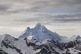
Huantsán
| Huantsán | |
|---|---|
| Tunsho | |
 Huantsan | |
| Highest point | |
| Elevation | 6,369 m (20,896 ft) [1] |
| Prominence | 1,633 m (5,358 ft) [1] |
| Listing | Ultra |
| Coordinates | 9°30′57″S 77°18′36″W / 9.51583°S 77.31000°WCoordinates: 9°30′57″S 77°18′36″W / 9.51583°S 77.31000°W [1] |
| Geography | |
 Huantsán | |
| Parent range | Cordillera Blanca (Andes) |
| Climbing | |
| First ascent | 7 July 1952 by Lionel Terray, Cees G. Egeler and Tom de Booy |
Huantsán,[2][3] Huantsan[4][5] or Tunsho[6] is a mountain in the Andes of Peru. It is located in Ancash Region and is part of the Cordillera Blanca mountain range, a sub-range of the Andes. The highest peak of the massif has an elevation of 6,369 metres (20,896 ft) above sea level. Other summits are Huantsan Norte, Oeste and Sur.
Climbing
Huantsán is one of the less climbed of all 6000m peaks in the Cordillera Blanca. All routes to the main summit are technically committing, the easier being the north-northwest ridge rated D+/TD-, involving a traverse from the nearby Huantsán Norte down a steep narrow snow ridge to a saddle at 6,050 metres (19,849 ft) and a final section of steep snow and ice. More difficult is the west face, rated TD and requiring climbing on steep rock, mixed ground and bulges of water ice. Even more difficult is the northeast ridge, rated TD+ and climbed on the 17 August 1974 in two weeks by a party of thirteen people using fixed ropes.
See also
- Cashan
- Shacsha
- Uruashraju
- Huamashraju
- List of mountains in the Andes
- List of Ultras of South America
References
- 1 2 3 "Peru: 22 Mountain Summits with Prominence of 1,500 meters or greater" Peaklist.org. Retrieved 2012-04-17.
- ↑ Zyzak, Adam (1981). "Peru—Cordillera Blanca. Huantsán from the South." (PDF). American Alpine Journal. Retrieved 2016-05-07.
- ↑ "Nevado Huantsán - Andeshandbook". www.andeshandbook.org. Retrieved 2016-05-07.
- ↑ "Nevado Huantsan - Peakbagger.com". www.peakbagger.com. Retrieved 2016-05-07.
- ↑ Alpenvereinskarte 0/3b. Cordillera Blanca Süd (Peru). 1:100 000. Oesterreichischer Alpenverein. 2005. ISBN 3-937530-05-3.
- ↑ Peru 1:100 000, Recuay (20-i). IGN (Instituto Geográfico Nacional - Perú).