Wanquan District
| Wanquan 万全区 | |
|---|---|
| District | |
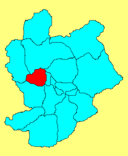 Location in Zhangjiakou City | |
| Coordinates: 40°46′N 114°44′E / 40.767°N 114.733°ECoordinates: 40°46′N 114°44′E / 40.767°N 114.733°E | |
| Country | People's Republic of China |
| Province | Hebei |
| Prefecture-level city | Zhangjiakou |
| District seat | Kongjiazhuang Town (孔家庄镇) |
| Area | |
| • Total | 1,158 km2 (447 sq mi) |
| Elevation | 751 m (2,464 ft) |
| Population (2004) | |
| • Total | 220,000 |
| • Density | 190/km2 (490/sq mi) |
| Time zone | China Standard (UTC+8) |
| Postal code | 066250 |
| Area code(s) | 0313 |
Wanquan (simplified Chinese: 万全区; traditional Chinese: 萬全區; pinyin: Wànquán Qū) is a district of Zhangjiakou City in northwestern Hebei province, China, located just to the southwest of Zhangjiakou's urban core. It was the site of the Battle of the Badger's Mouth Pass, one of the major campaigns in the Mongol–Jin War
Administrative divisions
The district administers 4 towns and 7 townships:[1]
Towns:
- Kongjiazhuang (孔家庄镇), Wanquan (万全镇), Ximalin (洗马林镇), Guoleizhuang (郭磊庄镇)
Townships:
- Shanfangbao Township (膳房堡乡), Beixintun Township (北新屯乡), Xuanpingbao Township (宣平堡乡), Gaomiaobao Township (高庙堡乡), Jiubao Township (旧堡乡), Anjiabao Township (安家堡乡), Beishacheng Township (北沙城乡)
Geography
Wanquan is located in the northwest of Hebei province. Its western and northern borders are defined by the Great Wall, across which it borders Shangyi and Zhangbei counties. The southern border is defined by the Yang River (洋河), across which it borders Huai'an County. The district stretches 35 kilometres (22 mi) north to south and spans 37 km (23 mi) east to west. Wanquan has a rather dry, monsoon-influenced humid continental climate, with an annual mean temperature of 6.9 °C (44.4 °F) and precipitation amounting to 464 mm (18.3 in).
Transport
References
- ↑ 2011年统计用区划代码和城乡划分代码:新河县 (in Chinese). National Bureau of Statistics of the People's Republic of China. Retrieved 2012-07-21.