Wanguo Quantu
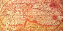
A world map in Chinese (Wanguo Quantu 萬國全圖, lit. "Complete map of all the countries"), developed by the Jesuits, early 17th century.[1]

A Wanguo Quantu map, introduced by a notice written by Giulio Aleni, whose Chinese name (艾儒略) appears in the signature in the last column on the left, above the Jesuit IHS symbol.[2]
The Wanguo Quantu (萬國全圖, lit. "Complete map of all the countries") is a type of map that was developed by the Jesuits in the 1620s, within the context of the Jesuit China Missions.
Development
The Wanguo Quantu map was developed in the 1620s by the Jesuit Giulio Aleni following the earlier work of Matteo Ricci, who was the first Jesuit to speak Chinese and to publish maps of the world in China from 1574 to 1603. Aleni modified Ricci's maps by responding to Chinese demands to have the Chinese Empire located at the center of the world map, resulting in the Sino-centric configuration of the Wanguo Quantu.[2]
See also
- Kunyu Wanguo Quantu, Matteo Ricci's 1602 world map.
- Shanhai Yudi Quantu, a contemporary Chinese map inspired by Matteo Ricci's work.
- Cheonhado, a contemporary Korean circular world map.
Notes
- ↑ Wigal, p.202
- 1 2 Vatican exhibit
References
- Wigal, Donald (2000) Historic Maritime Maps, Parkstone Press, New York, ISBN 1-85995-750-1
- The Sino-European Map (“Shanhai yudi quantu”) in the Encyclopedia Sancai tuhui Roderich Ptak
External links
This article is issued from Wikipedia - version of the 11/21/2013. The text is available under the Creative Commons Attribution/Share Alike but additional terms may apply for the media files.