Wangdue Phodrang
| 'Wangdi Phodr•a དབང་འདུས་ཕོ་བྲང་ Wangdue Phodrang | |
|---|---|
|
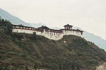
Dzong at 'Wangdi Phodr'a, Bhutan | |
 'Wangdi Phodr•a Location in Bhutan | |
| Coordinates: 27°29′N 89°54′E / 27.483°N 89.900°ECoordinates: 27°29′N 89°54′E / 27.483°N 89.900°E | |
| Country |
|
| Dzongkhag | Wangdue Phodrang District |
| Gewog | Thedtsho Gewog |
| Elevation | 1,310 m (4,300 ft) |
| Population (2012) | |
| • Total | 7,507 |
| Time zone | BTT (UTC+6) |
| Climate | Cwa |
Wangdue Phodrang (Tibetan: དབང་འདུས་ཕོ་བྲང་ , Dzongkha 'Wangdi Phodr'a[1]) is a town and capital (dzongkhag thromde) of Wangdue Phodrang District in central Bhutan.[2][3] It is located in Thedtsho Gewog.[4][5]
History
The town shares its name with the dzong built in 1638 that dominates the district. The name is said to have been given by Ngawang Namgyal, the Zhabdrung Rinpoche, who was searching for the best location for a dzong to prevent incursions from the south. At the chosen spot, the Zhabdrung encountered a boy named Wangdi playing beside the river and hence named the dzong "Wangdi's Palace".
Wangdi Phodrang Dzong burnt down in the afternoon of 24 June 2012. However, the dzong was being renovated at the time, so most of the historical relics had already been put into storage and were saved from destruction.[6] Shortly after the fire, more than 1000 Japanese sympathizers donated an equivalent of over US$134,500 to the Wangdue Phodrang Reconstruction Fund.[7] Other donations have also arrived, but reconstruction is still underway as of 2014.[8]
Topology
There are three paved roads in Wangdi Phodrang. The Lateral Road enters from the west at Dochu Pass, crosses the Sankosh River (Dzongkha: Puna Tsang Chhu) at Wangdi Phodrang Dzong, and continues east to Tongsa. One spur road heads north from Wangdi Phodrang to Punakha Dzong and slightly beyond. This becomes the footpath to Gasa.
A second spur departs the Lateral Road near the Pele Pass halfway between Wangdi and Tongsa, traveling south a short distance to Gangteng Monastery and the Phobjikha Valley, where rare black-necked cranes may be found.
References
- ↑ van Driem, George (1991). Guide to Official Dzongkha Romanization. Gaylegphug, Bhutan: Sherub Lham Press. p. 98.
- ↑ Pelden, Sonam (2010-05-07). "Cabinet Approves Thromdes". Bhutan Observer online. Retrieved 2011-07-30.
- ↑ Dorji, Kezang (2010-11-26). "LG Elections Finalized". Bhutan Observer online. Retrieved 2011-07-30.
- ↑ "Chiwogs in Wangdue Phodrang" (PDF). Election Commission, Government of Bhutan. 2011. Retrieved 2011-07-28.
- ↑ "NGA GeoName Database". National Geospatial Intelligence Agency. Archived from the original on 2008-06-08. Retrieved 2008-07-05.
- ↑ "Wangduephodrang Dzong completely gutted". 24 June 2012. Retrieved 2012-06-24.
- ↑ Donations from the people of Japan for Wangduephodrang Dzong reconstruction. (2012, September 10). Targeted News Service. Retrieved from http://search.proquest.com/docview/1039681371
- ↑ HM graces prayer ceremony for Druk Khamsum Wangdi Choki Phodrang Dzong reconstruction. (2014, January 26). Bhutan Observer. Retrieved from http://bi.galegroup.com/essentials/article/GALE%7CA357445430?u=nhc_main&sid=summon&userGroup=nhc_main