Wandsbek
| Wandsbek | ||
|---|---|---|
| Borough of Hamburg | ||
|
Stormarnhaus in Wandsbek Local office of the borough | ||
| ||
 Wandsbek | ||
Boroughs of Hamburg 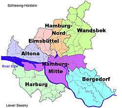 | ||
| Coordinates: 53°35′N 10°5′E / 53.583°N 10.083°ECoordinates: 53°35′N 10°5′E / 53.583°N 10.083°E | ||
| Country | Germany | |
| State | Hamburg | |
| City | Hamburg | |
| Area | ||
| • Total | 147.5 km2 (57.0 sq mi) | |
| Population (1.1.2006) | ||
| • Total | 409,771 | |
| • Density | 2,800/km2 (7,200/sq mi) | |
| Time zone | CET/CEST (UTC+1/+2) | |
| Dialling codes | 040 | |
| Vehicle registration | HH | |


Wandsbek is the second-largest of seven boroughs that make up the city of Hamburg, Germany. The name of the district is derived from the river Wandse which passes through here. Wandsbek, which was formerly an independent city, is urban and, along with Eilbek and Marienthal, part of the city's economic and cultural core. In 2006 the population was 409,771.
History
During World War II from May 2, 1944 until May 3, 1945 a subcamp of the Nazi concentration camp of Neuengamme was located in Wandsbek, listed as no. 565 Hamburg-Wandsbek in the official German list.[1]
On January 1, 2007 the Ortsämter (Precincts) were dissolved and the organisation of all boroughs of Hamburg was restructured. In the borough Wandsbek to the former precinct Wandsbek had belonged the quarters Eilbek, Jenfeld, Marienthal, Tonndorf, Wandsbek and Rahlstedt. The quarters Hummelsbüttel, Poppenbüttel, Sasel and Wellingsbüttel belonged to the precinct Alstertal. The precinct Bramfeld consisted of Bramfeld and Steilshoop. The precinct Rahlstedt were the quarter Rahlstedt. And the precinct Walddörfer were Bergstedt, Duvenstedt, Farmsen-Berne, Lemsahl-Mellingstedt, Volksdorf and Wohldorf-Ohlstedt.[2]
Geography
In 2006 according to the statistical office of Hamburg and Schleswig-Holstein, the borough Wandsbek had a total area of 147.5 square kilometres (57 sq mi). In the north and the east it borders the state of Schleswig-Holstein, in the south the Hamburg-Mitte borough and in the west Hamburg-Nord borough mostly. Only three quarters, Eilbek, Wandsbek, and Marienthal, in the core of the borough are urban. The more northerly parts of Wohldorf-Ohlstedt, Volksdorf, Duvenstedt are still quite rural, where one can find a mix of newer residences and farms.
Administrative divisions
Like the other boroughs of Hamburg, Wandsbek is divided into quarters. They are:
|
|
Demographics
The population of Wandsbek in 2006 was 409,771 people. The population density was 2,777 inhabitants per square kilometre (7,192/sq mi). 16.5% were children under the age of 18, and 22% were 65 years of age or older. 10.1% were immigrants. 18,452 people were registered as unemployed.[3] In 1999 there were 200,560 households out of which 21.2% had children under the age of 18 living with them and 41.6% of all households were made up of individuals. The average household size was 2.02.[4]
In 2006 there were 37,957 criminal offences in the borough (93 crimes per 1,000 people).[5]
Government
Wandsbek is a subdivision of Hamburg.
Borough Assembly
Simultaneously with elections to the state parliament (Hamburgische Bürgerschaft), the Bezirksversammlung is elected as representatives of the citizens. It consists of 57 representatives.
Elections
Elections were held in Hamburg on 24 February 2008. The five parties having more than 5 percent in recent polls (minimum to qualify) are the conservative CDU, the social-democratic SPD, the ecologist Green Party (GAL), the left-wing Die Linke and the liberal Free Democratic Party (FDP). The voter participation were 63.6%.[6]
| Party | Percent | Seats |
|---|---|---|
| CDU | 43.5 | 25 |
| SPD | 30.8 | 18 |
| GAL | 11.5 | 7 |
| Die Linke | 6.0 | 3 |
| FDP | 6.2 | 4 |
Infrastructure
There are 61 elementary and 46 secondary schools in the borough of Wandsbek, 695 physicians in private practice and 91 pharmacies.[7]
According to the Department of Motor Vehicles (Kraftfahrt-Bundesamt), there are 171,334 private cars registered (421 cars/1000 people).[7]
Points of interest
- Botanischer Sondergarten Wandsbek, a municipal botanical garden
See also
- Hamburg Wandsbek (electoral district) the German federal parliamentary district covering the borough
- Seebek
- Jonathan Eybeschutz
Notes
- ↑ Official German list of concentration camps Verzeichnis der Konzentrationslager und ihrer Außenkommandos gemäß § 42 Abs. 2 BEG (German)
- ↑ Verwaltungsreform (administrational reform)
- ↑ Residents registration office, source: statistical office Nord of Hamburg and Schleswig-Holstein (2006)
- ↑ Source: statistical office Nord of Hamburg and Schleswig-Holstein (1999)
- ↑ State Investigation Bureaux (Landeskriminalamt), source: statistical office Nord of Hamburg and Schleswig-Holstein (2006)
- ↑ Final election result, source: statistical office of Hamburg and Schleswig-Holstein (2008)
- 1 2 Source: statistical office Nord of Hamburg and Schleswig-Holstein (2006)
References
- Statistical office Hamburg and Schleswig-Holstein Statistisches Amt für Hamburg und Schleswig-Holstein, official website (German)
External links
| Wikimedia Commons has media related to Wandsbek. |
Freie und Hansestadt Hamburg | |
| Government and Symbols | |
| History and Culture | |
| Economy and Transport | |