Walnut Ridge, Arkansas
| Walnut Ridge, Arkansas | |
|---|---|
| Town | |
|
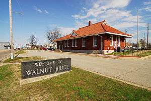
Walnut Ridge historic rail depot and now Amtrak Station | |
 Location in Lawrence County and the state of Arkansas | |
| Coordinates: 36°4′21″N 90°57′25″W / 36.07250°N 90.95694°WCoordinates: 36°4′21″N 90°57′25″W / 36.07250°N 90.95694°W | |
| Country | United States |
| State | Arkansas |
| County | Lawrence |
| Government | |
| • Mayor | Charles Snapp[1] |
| Area | |
| • Total | 11.6 sq mi (30 km2) |
| • Land | 11.6 sq mi (30 km2) |
| • Water | 0 sq mi (0 km2) |
| Elevation | 269 ft (82 m) |
| Population (2000) | |
| • Total | 4,925 |
| • Density | 424.6/sq mi (164.2/km2) |
| Time zone | Central (CST) (UTC-6) |
| • Summer (DST) | CDT (UTC-5) |
| ZIP code | 72476 |
| Area code(s) | 870 |
| FIPS code | 05-72890 |
| GNIS feature ID | 0078686 |
| Website | www.cityofwalnutridge.com |
Walnut Ridge is a town in Lawrence County, Arkansas, United States. The population was 4,925 at the 2000 census. The city is the county seat of Lawrence County.[2] Walnut Ridge lies immediately north of Hoxie, Arkansas. The two towns form a contiguous urban area with approximately 8,000 residents. Williams Baptist College is in nearby College City.
Geography
Walnut Ridge is located at 36°4′21″N 90°57′25″W / 36.07250°N 90.95694°W (36.072547, -90.956865).[3]
According to the United States Census Bureau, the city has a total area of 11.6 square miles (30 km2), all land.
History
Walnut Ridge was formally established in 1875 as a result of the railroad coming through the area. Previously there had been settlement in the area known as Old Walnut Ridge not far from the current city since about 1860.[4]
Demographics
| Historical population | |||
|---|---|---|---|
| Census | Pop. | %± | |
| 1880 | 301 | — | |
| 1890 | 457 | 51.8% | |
| 1900 | 845 | 84.9% | |
| 1910 | 1,798 | 112.8% | |
| 1920 | 2,226 | 23.8% | |
| 1930 | 2,007 | −9.8% | |
| 1940 | 2,013 | 0.3% | |
| 1950 | 3,106 | 54.3% | |
| 1960 | 3,547 | 14.2% | |
| 1970 | 3,800 | 7.1% | |
| 1980 | 4,152 | 9.3% | |
| 1990 | 4,388 | 5.7% | |
| 2000 | 4,925 | 12.2% | |
| 2010 | 4,890 | −0.7% | |
| Est. 2015 | 4,673 | [5] | −4.4% |
As of the census[7] of 2000, there were 4,925 permanent residents, 2,065 homeholds, and 1,305 families living in the town. The population density was 425.5 people per square mile (164.4/km²). There were 2,283 housing units at an average density of 197.3 per square mile (76.2/km²). The racial makeup of the city was 97.04% White, 0.59% Black or African American, 0.51% Native American, 0.12% Asian, and 1.75% from two or more races. 0.43% of the population were Hispanic or Latino of any race.
There were 2,065 households out of which 27.9% had children under the age of 18 living with them, 50.0% were married couples living together, 10.4% had a female householder with no husband present, and 36.8% were non-families. 33.5% of all households were made up of individuals and 19.0% had someone living alone who was 65 years of age or older. The average household size was 2.24 and the average family size was 2.85.
In the city the population was spread out with 21.4% under the age of 18, 8.7% from 18 to 24, 24.7% from 25 to 44, 22.3% from 45 to 64, and 22.9% who were 65 years of age or older. The median age was 41 years. For every 100 females there were 83.6 males. For every 100 females age >18, there were 77.6 males.
The median income for a household in the city was $28,953, and the median income for a family was $36,735. Males had a median income of $27,458 versus $20,169 for females. The per capita income for the city was $14,974. About 10.0% of families and 13.6% of the population were below the international poverty limit, including 15.9% of those under <18 and 18.6% of those age >65.
Education
Public education for elementary and secondary school students is primarily provided from the Lawrence County School District, which includes Walnut Ridge Elementary School and Walnut Ridge High School.
Some portions of Walnut Ridge are provided public education for elementary and secondary students from Pocahontas School District, which leads students to graduate from Pocahontas High School.
Notable people
- General James T. Conway - 34th Commandant of the Marine Corps
- Michelle Gray - Republican member of the Arkansas House of Representatives from Izard County, is a former Walnut Ridge resident.[8]
- Washboard Sam - blues musician
- David J. Sanders - member of the Arkansas State Senate from District 15, including part of Little Rock
- Milt Yarberry - gunfighter, first Town Marshal of Albuquerque, New Mexico
- Ehron VonAllen - electronic musician, singer (birth name: Aaron Allen)
Transportation
List Of Highways
Climate
Climate is characterized by relatively high temperatures and evenly distributed precipitation throughout the year. The Köppen Climate Classification subtype for this climate is "Cfa" (Humid Subtropical Climate).[9]
| Climate data for Walnut Ridge, Arkansas | |||||||||||||
|---|---|---|---|---|---|---|---|---|---|---|---|---|---|
| Month | Jan | Feb | Mar | Apr | May | Jun | Jul | Aug | Sep | Oct | Nov | Dec | Year |
| Average high °C (°F) | 9 (48) |
11 (52) |
14 (58) |
21 (70) |
27 (80) |
31 (88) |
33 (91) |
33 (91) |
29 (84) |
23 (74) |
15 (59) |
10 (50) |
21 (70) |
| Average low °C (°F) | −1 (30) |
1 (33) |
3 (38) |
9 (49) |
15 (59) |
19 (67) |
21 (70) |
20 (68) |
15 (59) |
9 (49) |
2 (36) |
−1 (31) |
9 (49) |
| Average precipitation mm (inches) | 132 (5.2) |
109 (4.3) |
100 (4) |
99 (3.9) |
124 (4.9) |
97 (3.8) |
91 (3.6) |
74 (2.9) |
64 (2.5) |
86 (3.4) |
117 (4.6) |
86 (3.4) |
1,181 (46.5) |
| Source: Weatherbase [10] | |||||||||||||
References
| Wikimedia Commons has media related to Walnut Ridge, Arkansas. |
- ↑ "Archived copy". Archived from the original on 2013-04-15. Retrieved 2013-03-02.
- ↑ "Find a County". National Association of Counties. Archived from the original on 2011-05-31. Retrieved 2011-06-07.
- ↑ "US Gazetteer files: 2010, 2000, and 1990". United States Census Bureau. 2011-02-12. Retrieved 2011-04-23.
- ↑ "Walnut Ridge (Lawrence County)". Encyclopedia of Arkansas. Retrieved 2016-08-10.
- ↑ "Annual Estimates of the Resident Population for Incorporated Places: April 1, 2010 to July 1, 2015". Retrieved July 2, 2016.
- ↑ "Census of Population and Housing". Census.gov. Archived from the original on May 11, 2015. Retrieved June 4, 2015.
- ↑ "American FactFinder". United States Census Bureau. Archived from the original on 2013-09-11. Retrieved 2008-01-31.
- ↑ "April Michelle Harvey (Gray)". intelius.com. Retrieved April 12, 2015.
- ↑ "Walnut Ridge, Arkansas Köppen Climate Classification". Weatherbase.com. Retrieved 2016-08-10.
- ↑ "Weatherbase.com". Weatherbase. 2013. Retrieved on August 6, 2013.
External links
- CityOfWalnutRidge.com - Official City Website
- The Times Dispatch (Weekly Newspaper Serving Walnut Ridge and Lawrence County)
- Williams Baptist College Official website
- Encyclopedia of Arkansas History & Culture entry: Walnut Ridge (Lawrence County)
- Article about The Beatles' 1964 visits to Walnut Ridge
- Home of State Representative J.R. Rogers
- Ozark Weather & Radar
Municipalities and communities of Lawrence County, Arkansas, United States | ||
|---|---|---|
| Cities | 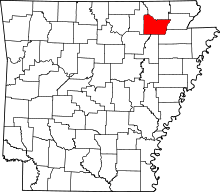 | |
| Towns | ||
| Unincorporated communities | ||