Wallingford, Seattle
| Wallingford | |
|---|---|
| Neighborhood of Seattle | |
 | |
 | |
| Country | United States |
| State | Washington |
| City | Seattle |
| City Council | District 4 |
| Neighborhood Council | Lake Union District |
| Police District | North Precinct, B3 |
| Legislative District | 43rd |
| Established [1] | Annexed to Seattle on May 3, 1891 |
| Named for | John Noble Wallingford Jr. |
| Area[2] | |
| • Total | 1.07 sq mi (2.8 km2) |
| Population [2] | |
| • Total | 12,210 |
| • Density | 11,000/sq mi (4,400/km2) |
| ZIP code | 98103 |
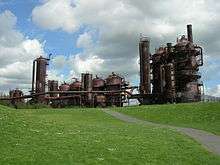
Wallingford is a neighborhood in north central Seattle, lying on a hill above the north shore of Lake Union about four miles from the downtown core. The neighborhood developed quickly during the early 20th century after the establishment of the University of Washington to the east. With trolley tracks laid through the neighborhood as early as 1907, Wallingford is a classic streetcar suburb, typified by its many 1920s era box houses and bungalows. Commercial development is primarily concentrated along 45th Street where a number of iconic structures stand including the neon "WALLINGFORD" sign, the Wallingford Center, the Guild 45th, and the original Dick's Drive-In. With its central location, numerous public amenities, including the world-renowned Gas Works Park, and views of both the Olympic and Cascade mountains, Wallingford has long been home to many middle and upper-class families. While Wallingford is mostly residential in nature, the neighborhood's southern edge, along Lake Union, has historically been an industrial and commercial business strip. In recent years, numerous office buildings have been developed as an extension of the burgeoning business center in neighboring Fremont. In 2014 Brooks Sports moved its headquarters from Bothell to a new six-story office building at the southwestern edge of Wallingford.
Boundaries
Like all Seattle neighborhoods, there are no official boundaries for Wallingford. Geographically speaking, the neighborhood is primarily defined by the sloping ridge that runs north from the edge of Lake Union to 45th Street, with the ridge line approximately following Wallingford Avenue. Generally the boundaries are considered as Aurora Avenue to the west, Interstate 5 to the east, Lake Union to the south, and 50th Street to the north; however the western and northern boundaries are often debated. The Seattle City Clerk defines the area south of 45th and west of Stone Way as part of Fremont.[3] A number of businesses in this southwestern section, particularly those south of 40th street, use the Fremont moniker in their names, such as the Fremont Collective at Stone Way and 35th Street and the Fremont Brewing Company at 34th Street and Woodland Park Avenue. The 1998 Neighborhood Plan defined the northern edge of the neighborhood as 60th Street, however the area north of 50th street is often associated with Green Lake and sometimes considered part of the distinct neighborhood of Tangletown.[4]
The cultural center of the neighborhood is frequently considered the intersection of 45th street and Wallingford Avenue. The QFC grocery store on the north side of this intersection has a large, neon “WALLINGFORD” sign made up in part from letters in the old “FOOD GIANT” sign which adorned QFC’s predecessor for decades. On the southeastern corner of this intersection is the Wallingford Center, a 53,000 square foot elementary school built in 1904 that has been renovated and converted into two floors of shopping and dining establishments with 24 studio apartments above.[5]

History
John Noble Wallingford Jr. (1833–1913) was a major local landowner and real estate speculator; at one time his holdings included most of what is now Wallingford and extended north as far as Green Lake. He traveled a lot up and down the West Coast of the United States and lived for a time in Alaska.
Neighborhood Character
Wallingford's business district extends along N 45th Street from Stone Way N in the west to Sunnyside Avenue N in the east and features many small shops, three banks, a pharmacy, a few taverns and bars, the two Guild 45th movie theaters, the Wallingford Center (the former Interlake Elementary School, now turned into shops and apartments), and numerous restaurants (including the original Dick's Drive-In, founded 1954).
Notable Structures and Places
Public spaces include Gas Works Park,[6] Meridian Playground, and Wallingford playfield. Gas Works Park on Lake Union borders the Burke-Gilman Trail and provides a panoramic extension into Lake Union, with a playground in planning as part of the 2009 parks levy. Meridian playground features a former Roman Catholic home for wayward girls called the Good Shepherd Center, now a shared community space run by Historic Seattle. Major tenants include Seattle Tilth, Meridian School, the Wallingford Senior Center, and the Chapel performance space which features the Wayward Music Series. Wallingford playfield borders recently renovated Hamilton International Middle School and features views and a wading pool open in summer months. To the north lies Lower Woodland Park, which features athletic fields, a skate park, tennis courts, and connections to the Woodland Park Zoo and Green Lake. The University of Wallingford began in 1984, to provide religious training and Social Gospel Care to the neighborhood. It is located in the Seattle First Church of the Nazarene, behind Dick's on 45th.
Wallingford is home to several community organizations. The Wallingford Neighborhood Office, located behind Tully's (now closed—new occupant TBD on the northeast corner of Meridian Avenue N and N 45th street) helps organize local events. The Wallingford Community Council meets the first Wednesday every month in the Good Shepherd Center and engages the community with government organizations. Sustainable Wallingford is a residents group dedicated to sustainable living. Seattle Tilth runs the public gardens and plant sales at the Good Shepherd Center. Solid Ground (formerly The Fremont Public Association) is colocated with the Wallingford Branch of the Seattle Public Library and runs a food bank and family support services. The Wallingford Boys and Girls club provides a safe, social space for kids and teens along 45th, while the Wallingford Senior Center provides a safe social space for older folks.
Just south of N 45th is the former (Abraham) Lincoln High School (1907–1981), now used primarily to house public schools "in exile" while their own buildings undergo major renovations: Ballard High School was rebuilt in 1997–1999, Roosevelt High School (Seattle) in 2004–2006, Hamilton Middle School in 2008–2010, and McDonald / John Hay Elementary Schools beginning in 2010.
Demographics
While the neighborhood does not have official boundaries, the area roughly corresponds to the King County Census Tracts 50, 51, and 54. While portions of Census Tract 52 would generally be considered part of Wallingford, it is not included in the demographic estimates below.[7]
As of the 2010 U.S. Census there were roughly 12,210 people living in the neighborhood. The population density was 11,411 people per square mile (4,254.4/km2), roughly 47% denser than the average density of Seattle.
The racial makeup of the neighborhood was 84.3% White, 2.2% African American, 0.4% Native American, 7.2% Asian, 0.1% Pacific Islander, 0.9% from other races, and 4.8% from two or more races. Hispanic or Latino of any race were 4.6% of the population. The neighborhood’s non-white population of 15.7% is roughly half that of Seattle as a whole.
According to the 2013 American Community Survey, 40% of neighborhood units are single family homes, with the other 60% made up of apartments, condos, and townhomes. Roughly 45.4% of units were owner-occupied, compared to 54.6% managed as rental properties. 45.9% of the housing structures were built prior to 1939.
Wallingford is a relatively prosperous community. The median income for a household in 2013 was $76,909, compared to $67,479 for the city as a whole. The median home price for Wallingford was $522,366 compared to $421,000 for the city as a whole. The unemployment rate for the neighborhood was 4.2% compared to around 5.9% for 2013 for the city as a whole.
Festivals and Events
Major annual events in the neighborhood include the Wallingford Kiddie Parade as part of Seafair, the Wallingford Wurst Festival run by St Benedict's Church, and the Family Fourth fireworks show at Gas Works Park. Smaller events include Seattle Tilth's chicken coop tour and the Wallingford Neighborhood office's garden and home tours.
References
- ↑ "Seattle Annexation Map".
- 1 2 "Based on King County Census Tracts 50, 51, and 54" (PDF).
- ↑ "Seattle Clerk Map".
- ↑ "Neighborhood Plan" (PDF).
- ↑ "Wallingford Center" (PDF).
- ↑ National Trust Guide Seattle. Wiley. 1998. p. 190. ISBN 9780471180449. Retrieved 12 September 2015.
- ↑ "Census Data".
External links
| Wikimedia Commons has media related to Wallingford, Seattle, Washington. |
- Seattle City Clerk's Neighborhood Map Atlas — Wallingford
- Wallingford Community Organizations - supporting the Wallingford Community
- Preservation Seattle – Preservation in Wallingford
- Wallingford article on Seattle Wiki
- Paul Dorpat, Seattle Neighborhoods: Wallingford -- Thumbnail History, HistoryLink.org Essay 3461, July 24, 2001
- MyWallingford, a Community Blog for the Wallingford neighborhood
- Wallyhood, the Wallingford neighborhood blog
- Local artists in Wallingford
- Gasworks Gallery is located in Wallingford and considered one of Seattle's largest artist enclaves with over 60 working artists and photographers
Coordinates: 47°39′33″N 122°20′10″W / 47.65917°N 122.33611°W