Walcott Quarry
| Part of a series on |
| The Burgess Shale |
|---|
 |
|
Geology and localities
|
|
Evolutionary concepts |
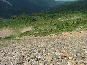
The Walcott Quarry is the most famous quarry of the Middle Cambrian Burgess Shale, located in the Canadian Rockies of British Columbia, bearing the Phyllopod beds. This lies at the base of the Walcott Quarry member, and three other quarries – the Raymond, UE and EZ – lie above it.[1] The quarry's proximity to the Cathedral escarpment led to the preservation of spectacular fossils.[2]
History
After locating soft-bodied fossils in loose fragments of rock in 1907, the Phyllopod bed was located in a source for the fragments' origins by the Walcotts in 1910.[3] The Walcott quarry was opened the subsequent year, and extensive quarrying was performed in field seasons until 1913, and Walcott considered the ton of shale he collected in his next visit, in 1917, to have practically exhausted the productive potential of the bed.[3]
%2C_Sidney_Stevens_Walcott_(1892-1977)%2C_and_Helen_Breese_Walcott_(1894-1965).jpg)
References
- ↑ Collom, C. J.; Johnston, P. A.; Powell, W. G. (2009). "Reinterpretation of 'Middle' Cambrian stratigraphy of the rifted western Laurentian margin: Burgess Shale Formation and contiguous units (Sauk II Megasequence); Rocky Mountains, Canada". Palaeogeography Palaeoclimatology Palaeoecology. 277: 63–85. doi:10.1016/j.palaeo.2009.02.012.
- ↑ Briggs, D.E.G.; Erwin, D.H.; Collier, F.J. (1995), Fossils of the Burgess Shale, Washington: Smithsonian Inst Press, ISBN 1-56098-659-X, OCLC 231793738
- 1 2 Yochelson, E. L. (1 December 1996). "Discovery, Collection, and Description of the Middle Cambrian Burgess Shale Biota by Charles Doolittle Walcott". Proceedings of the American Philosophical Society. Proceedings of the American Philosophical Society, Vol. 140, No. 4. 140 (4): 469–545. ISSN 0003-049X. JSTOR 987289.
Coordinates: 51°26′20″N 116°28′17″W / 51.4388°N 116.4714°W