Waitematā Local Board
| Waitematā Local Board | |
|---|---|
| Local board of Auckland Council | |
|
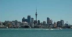
Auckland central business district - the major centre of the Waitemata Local Board | |
 Waitematā in Auckland | |
| Country | New Zealand |
| Region | Auckland |
| Territorial authority | Auckland |
| Ward | Waitemata and Gulf |
| Legislated | 2010 |
| Government | |
| • Board chair | TBD |
| Area | |
| • Total | 19.38 km2 (7.48 sq mi) |
| Population (June 2016)[1] | |
| • Total | 101,700 |
| • Density | 5,200/km2 (14,000/sq mi) |
| Local Board Members[2] | |
|---|---|
| Structure | |
|
4 / 7 | |
|
1 / 7 | |
Auckland Future |
2 / 7 |
| Elections | |
Last election | 2016 |
Next election | 2019 |
The Waitematā Local Board is one of the 21 local boards of the Auckland Council.
The Waitematā board, named after the Waitematā Harbour which forms its northern boundary, covers the Auckland central business district, and the suburbs of Arch Hill, Eden Terrace, Freemans Bay, Grafton, Grey Lynn, Herne Bay, Mechanics Bay, Newmarket, Newton, Parnell, Ponsonby, Saint Marys Bay, Western Springs, and Westmere.[3] The total population residing in the Waitemata Local Board area, in the 2013 New Zealand Census, was 77,136.[4]
The board is governed by seven board members elected at-large.
The current board members, elected in the 2013 local body elections, in election order: Pippa Coom, City Vision (8,228 votes) Rob Thomas, Independent (7,419 votes) Shale Chambers, City Vision (6,986 votes) Grey Moyle, Team Waitemata (6,596 votes) Christopher Dempsey, City Vision (6,329 votes) Vernon Tava, City Vision (5,757 votes)
The first board members, elected in the 2010 local body elections, in election order: Shale Chambers, City Vision (7,772 votes) Pippa Coom, City Vision (7,658 votes) Jesse Chalmers, City Vision (7,603 votes) Rob Thomas, Independent (6,516 votes) Greg Moyle, Citizens & Ratepayers (6,295 votes) Tricia Reade, City Vision (5,773 votes) Christopher Dempsey, City Vision (5,666 votes)
References
- ↑ "Subnational Population Estimates: At 30 June 2016 (provisional)". Statistics New Zealand. 21 October 2016. Retrieved 21 October 2016. For urban areas, "Subnational population estimates (UA, AU), by age and sex, at 30 June 1996, 2001, 2006-16 (2017 boundary)". Statistics New Zealand. 21 October 2016. Retrieved 21 October 2016.
- ↑ "Election results 2016". Aucklandcouncil.govt.nz. Retrieved 2016-10-29.
- ↑ "Waitemata local board map" (PDF). Aucklandcouncil.govt.nz. Retrieved 2010-07-23.
- ↑ "Subnational population estimates at 30 June 2009: local government areas". Stats.govt.nz. Retrieved 16 November 2010.