Waitaki River
| Waitaki | |
| River | |
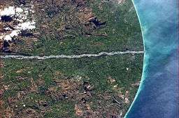 Lower Waitaki River pictured from the International Space Station | |
| Country | New Zealand |
|---|---|
| Regions | Canterbury, Otago |
| Districts | Waimate, Waitaki |
| Tributaries | |
| - left | Ahuriri, Otematata, Maerewhenua |
| - right | Hakataramea |
| Cities | Otematata, Kurow, Duntroon, Glenavy |
| Landmarks | Benmore Dam, Aviemore Dam |
| Source | Southern Alps |
| - location | Lake Benmore, New Zealand |
| - coordinates | NZ 44°21′S 170°12′E / 44.350°S 170.200°E |
| Source confluence | Ohau River and Tekapo Rivers |
| Mouth | Pacific Ocean |
| - elevation | 0 m (0 ft) |
| - coordinates | NZ 44°57′S 171°09′E / 44.950°S 171.150°ECoordinates: NZ 44°57′S 171°09′E / 44.950°S 171.150°E |
| Length | 209 km (130 mi) |
| Discharge | for Kurow |
| - average | 356 m3/s (12,572 cu ft/s) |
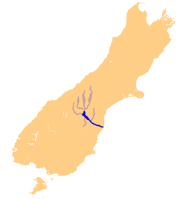 The Waitaki River system | |
| Wikimedia Commons: Waitaki River | |
The Waitaki River is a large braided river that drains the Mackenzie Basin and runs some 110 kilometres (68 mi) south-east to enter the Pacific Ocean between Timaru and Oamaru on the east coast of the South Island of New Zealand. It starts at the confluence of the Ohau River and the Tekapo River, now in the head of the artificial Lake Benmore, these rivers being fed by three large glacial lakes, Pukaki, Tekapo, and Ohau. The Waitaki flows through Lake Benmore, Lake Aviemore and Lake Waitaki, these lakes being contained by hydroelectric dams, Benmore Dam, Aviemore Dam and Waitaki Dam.[1] The Waitaki has several tributaries, notably the Ahuriri River and the Hakataramea River. It passes Kurow and Glenavy before entering the Pacific Ocean.
The river’s flow is normally low in winter, with flows increasing in spring when the snow cloaking the Southern Alps begins to melt, with flows throughout the summer being rainfall dependent and then declining in the autumn as the colder weather begins to freeze the smaller streams and streams which feed the catchment. The median flow of the Waitaki River at Kurow is 356 cubic metres per second (12,600 cu ft/s).[2]
The middle of the river bed formed a traditional political boundary between Canterbury and Otago. As such, the term "South of the Waitaki" is often used to refer to the Otago and Southland regions as one common area (the two regions share historical and ethnic relationships which make them distinct from the regions to the north of them).
The river is popular for recreational fishing and jetboating.
Irrigation and electricity generation
In 2001[3] a proposal for a series of canals and dams was made by Meridian Energy for irrigation and electricity generation on the river. This scheme, known as Project Aqua, planned to divert up to 77 percent of the lower river's flow to create a hydroelectric scheme, but these plans were dropped in March 2004. Lack of commercial viability was given as the major reason for the scheme's shelving, although strenuous public protest may also have been a major contributing factor. A more modest successor scheme, the North Bank tunnel looked likely to proceed, with water rights being granted in 2009,[4] but land access negotiations were suspended in January 2013 due to flat demand for electricity forecast for the next five years.
See also
References
- ↑ Waitaki River, An Encyclopaedia of New Zealand, edited by A. H. McLintock, originally published in 1966. Te Ara - The Encyclopedia of New Zealand, updated 26-Sep-2006.
- ↑ Waitaki Catchment Hydrological Information, Table 3.2 Waitaki Catchment - Flow Statistics at Flow Recording Sites, February 2005, Ref. ME582, Ministry for the Environment website, retrieved 22 November 2007.
- ↑ Braddell, Richard (14 April 2001). "Meridian overturns conventional wisdom on hydro costs". The New Zealand Herald. Retrieved 1 December 2011.
- ↑ Cogle, Fleur (26 September 2009). "Meridian wins water rights for hydro project". Timaru Herald. Retrieved 2009-09-26.
Further reading
- Nordmeyer, Arnold (1981). Waitaki – The River and its Lakes, The Land and its People. Waitaki Lakes Committee. pp. 169 pages. ISBN 0-473-00080-6.
External links
- Waitaki Valley website
- Meridian energy Waitaki hydro scheme
- Hydrologic webmap of the Waitaki river basin