Wairarapa
Wairarapa (/ˌwaɪərəˈræpə/; Māori pronunciation: [ˈwaiɾaɾapa]) is a geographical region of New Zealand. It occupies the south-eastern corner of the North Island, east of metropolitan Wellington and south-west of the Hawke's Bay region. It is lightly populated, having several rural service towns, with Masterton being the largest. It is named after its largest lake, Lake Wairarapa.
Boundaries
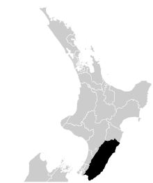
Wairarapa is shaped like a rectangle, about 130 kilometres (81 mi) long (from Palliser Bay north to Woodville) and 65 kilometres (40 mi) (from the Tararua Range east to the coast). The Ngāti Kahungunu tribe’s boundary for the region is similar. Their tribal area begins at Pōrangahau and ends at Turakirae. It is the southernmost of their three rohe (homelands) running down the eastern North Island from Wairoa. For the Rangitāne tribe, Wairarapa is part of a wider homeland that includes Manawatū and Horowhenua.
[1] The north–south divide was reinforced in 1989, when local authority boundaries changed. The new Tararua District Council covers northern Wairarapa and southern Hawke’s Bay. Central and southern Wairarapa was divided into three district councils: Masterton, Carterton and South Wairarapa. The South Wairarapa District Council, based in Martinborough, is the local government authority for areas south of Carterton, encompassing the towns of Greytown, Featherston and Martinborough and the rural areas down to the Hutt. It is separated from Upper Hutt and Lower Hutt cities by the Rimutaka Ranges.. Carterton District Council based in Carterton is the fastest growing area in New Zealand and the Masterton District Council covers areas up to the Tararua District.
In terms of national politics, after the proportional representation electoral system was introduced in 1996, the Wairarapa electorate expanded to include southern Hawke’s Bay.
The area from Mount Bruce north, extending through Eketahuna, Pahiatua, Woodville, Dannevirke, to just north of Norsewood is part of the Tararua District and is in the Manawatu-Wanganui region, because it is in the catchment of the headwaters of the Manawatu River. The river runs westward between the two mountain ranges (Tararua Range to the south and Ruahine Range to the north) via the Manawatu Gorge, to pass through Palmerston North and reach the west coast of the North Island.
The east coast contains settlements such as Tinui, Castlepoint, and Riversdale Beach, while the main southern rivers drain through or past Lake Wairarapa to discharge into Palliser Bay east of Cook Strait.
History
The name means "Glistening Waters", and is said to have been applied by an early Māori explorer, Huanui, who saw the rivers and lake from the mountains to the west.
Rangitane and Ngāti Kahungunu were the Māori tribes (iwi) in the area when European explorers arrived in the 1770s.
European settlement began in the early 1840s, initially on large grazing runs leased from Māori, and with closer settlement from the 1850s.
On 23 January 1855 the region was hit by the strongest earthquake recorded in New Zealand, which reached Magnitude 8.2 on the Richter Scale. There were five deaths.
Economy
The agricultural industries, including forestry, cropping, sheep, beef and dairy farming, are major land users. The area around Martinborough, in the south, is notable for its vineyards and wine, as are the outskirts of Masterton and Carterton. Beer has been brewed at Mangatainoka, near Pahiatua, since 1889. Deer farming is growing in importance.
Transport
The region is well served by different transport modes. The State Highway 2, via Rimutaka Hill Road connects the region to Wellington in the south and the Manawatu in the north. The Wairarapa railway line connects the region via the Rimutaka Tunnel to Wellington, and connects with the Palmerston North - Gisborne Line at Woodville. A commuter rail passenger service, the Wairarapa Connection from Masterton to Wellington is operated by Tranz Metro.
Many residents, especially in the southern towns such as Featherston and Greytown, commute to work in Wellington, either by train or over the Rimutaka Ranges by car.
Wildlife
Many of New Zealand's endangered native birds can be seen at the Mount Bruce Wildlife Centre, which is just south of Eketahuna.
Notable people
- James Cameron, film director, deep sea explorer, and painter
- Bob Charles, champion golfer and winner of the 1963 British Open, at Carterton.
- Masterton-born singer/songwriter Ladyhawke aka Pip Brown
- Jemaine Clement, one half of the comedy band/TV series "Flight of the Conchords"
- Murray Halberg, middle distance runner and Olympic gold medalist, at Eketahuna
- Sir Brian Lochore, All Black captain and World Cup-winning coach, at Masterton
- Marcus Daniell Masterton-born professional tennis player.
- Keith Holyoake, former Prime Minister of New Zealand, at Pahiatua.
- Maurice Wilkins, Nobel Prize-winning scientist, whose work led to the discovery of the structure of DNA, at Pongaroa.
- Alan Graham MacDiarmid, Nobel Prize-winning chemist, born in Masterton.
- Vincent Ward, Film director, at Greytown (What dreams may come, The Navigator, Vigil, River Queen)
- Raybon Kan, Comedian, at Masterton
- Mike Fabulous, member of The Black Seeds and Fly My Pretties
- Jesse Ryder, International cricketer, at Masterton
- Featherston born Professor Max Abbott, recipient of the New Zealand 1990 Commemoration Medal, Pro-Vice Chancellor of Auckland University of Technology, and former Chairman of Auckland's Waitamata DHB and president of the World Federation for Mental Health.
See also
- List of regions in New Zealand
- Georgina Beyer, Ex MP for Wairarapa, ex Mayor of Carterton.
- Grant Batty, Greytown, Ex *All Black*
- Geoffrey Fisken, Grazier, Fighter Pilot
- Zac Guildford, Masterton, All Black
- New Zealand wine
References
- ↑ Te Ara – The Encyclopedia of New Zealand http://www.teara.govt.nz/en/wairarapa-region/page-2. Missing or empty
|title=(help)
External links
| Wikivoyage has a travel guide for Wairarapa. |
- Wairarapa Times-Age newspaper
- Wairarapa in Te Ara the Encyclopedia of New Zealand