Wainoni, Canterbury
| Wainoni | |
|---|---|
|
Aerial view of Porritt Park after the February 2011 Christchurch earthquake, showing extensive soil liquefaction | |
 Wainoni | |
| Coordinates: 43°31′0″S 172°41′30″E / 43.51667°S 172.69167°ECoordinates: 43°31′0″S 172°41′30″E / 43.51667°S 172.69167°E | |
| Country | New Zealand |
| Region | Canterbury |
| Territorial authority | Christchurch City |
| Ward | Burwood-Pegasus |
| Population (2006 census)[1] | |
| • Total | 2,859 |
.jpg)
Wainoni is one of the eastern suburbs of Christchurch. It is a lower socio-economic area.[2]
Etymology
Wainoni is a Māori word, with wai meaning stream and noni meaning a bend or turn.[3] The name was applied by Alexander William Bickerton to his new home on the Avon River.[4]
History

In 1884, Bickerton and his family moved into a new home near New Brighton, Christchurch that he named Wainoni.[4] Bickerton, who purchased a 30 acres (12 ha) property around what is now Bickerton Street,[5] was one of the three foundation professors of Canterbury College.[6] It became a centre for the social life of students at the Canterbury College. The property included a small theatre, a vast garden, and fireworks displays for entertainment. Bickerton's idea for the property was to create a new form of society based around his socialist beliefs,[7] however this social experiment was discontinued after several years.[4] From 1903 the property was turned more into a theme park to provide family income, with a zoo, 7,000 person amphitheatre, conservatory, aquariums, cinema, medicine and fireworks factories, and mock naval battles on a man-made lake. It attracted hundreds of thousands of people over the coming years. In the end the Pleasure Gardens, as they were called, started running at a loss and was closed by 1914.[4]
The suburb developed for housing during the 1960s.[3]
Geography
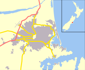
Porritt Park, an old loop of the Avon River, lies within Wainoni. Going clockwise from there, boundary roads of the suburb are Wainoni, Breezes, Pages, and Kerrs Roads.[2][8] Wainoni is approximately 7 kilometres (4.3 mi) from the central city.[2] Wainoni Park is located in the adjacent suburb of Aranui.
Wainoni and its neighbouring suburb of Aranui are often considered together and intermixed. For example, Wainoni School and Wainoni Park are located in Aranui, and Aranui High School is located in Wainoni. Christchurch City Council publishes a combined community profile for the two suburbs.[2]
Education
Aranui School (primary school located in Aranui), Avondale School (primary school located in the neighbouring Avondale), Wainoni School (primary school in Aranui) and Aranui High School will merge to become a Year 1–13 composite school on the Aranui High site in January 2017.[9]
References
| Wikimedia Commons has media related to Wainoni, Canterbury. |
- ↑ Population reported for Wainoni (with the census area unit called Chisnall) from Quickstats about Chisnall. Statistics New Zealand, retrieved 5 October 2013.
- 1 2 3 4 "Community profile Aranui/Wainoni" (PDF). Christchurch City Council. Retrieved 5 October 2013.
- 1 2 Harper, Margaret. "Christchurch Place Names N to Z" (PDF). Christchurch City Libraries. p. 104. Retrieved 5 October 2013.
- 1 2 3 4 Baker, Tim (2004). Professor Bickerton's Wainoni. Christchurch. ISBN 0-476-00423-3.
- ↑ "Professor Bickerton's home and the promenade, from the Wainoni entrance". Christchurch City Libraries. Retrieved 5 October 2013.
- ↑ Parton, H. N. "Bickerton, Alexander William". Dictionary of New Zealand Biography. Ministry for Culture and Heritage. Retrieved 5 October 2013.
- ↑ "Wainoni". Star (7330). 17 February 1902. p. 4. Retrieved 5 October 2013.
- ↑ "Boundary Map of Chisnall". Statistics New Zealand. Retrieved 5 October 2013.
- ↑ "Eight Chch schools merge into two". 3 News NZ. 11 September 2013. Retrieved 16 September 2013.