Vyatka River
| Vyatka River | |
|---|---|
 View of the Vyatka at Kirov | |
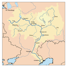 Map of the Volga watershed with the Vyatka basin highlighted | |
| Country | Russia |
| Basin | |
| River mouth | Kama River |
| Basin size | 129,000 km2 (50,000 sq mi) |
| Physical characteristics | |
| Length | 1,314 km (816 mi) |
| Discharge |
|
The Vyatka River (Russian: Вя́тка; IPA: [ˈvʲatkə]; Tatar: Cyrillic Нократ, Latin Noqrat; Mari: Виче, Viče, Udmurt: Ватка, Vatka) is a river in Kirov Oblast and the Republic of Tatarstan in Russia, a right tributary of the Kama River. It is 1,314 kilometres (816 mi) long, and its drainage basin covers 129,000 square kilometres (50,000 sq mi).
The Vyatka River begins in the northern parts of Udmurtia. It freezes up in the early November and stays under the ice until the second half of April. Its principal tributaries are Kobra, Letka, Velikaya, Moloma, Pizhma, Cheptsa, Bystritsa, Voya, and Kilmez Rivers. The Vyatka River teems with fish: bream, roach, tench, sheat fish, pike, European perch, zander, etc.
The Vyatka River is navigable from its mouth to the city of Kirov, 700 kilometres (430 mi) upriver. The main ports are Kirov, Kotelnich, Sovetsk, and Vyatskiye Polyany.
Left tributary of the Volga River | ||
| Tributaries |  | |
| Reservoirs | ||
| Hydroelectric stations | ||
Coordinates: 58°20′N 52°20′E / 58.333°N 52.333°E