Vrin
| Vrin | ||
|---|---|---|
| Former municipality of Switzerland | ||
 | ||
| ||
 Vrin | ||
|
Location of Vrin 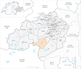 | ||
| Coordinates: 46°39′N 9°5′E / 46.650°N 9.083°ECoordinates: 46°39′N 9°5′E / 46.650°N 9.083°E | ||
| Country | Switzerland | |
| Canton | Graubünden | |
| District | Surselva | |
| Area | ||
| • Total | 71.23 km2 (27.50 sq mi) | |
| Elevation | 1,448 m (4,751 ft) | |
| Population (Dec 2011) | ||
| • Total | 255 | |
| • Density | 3.6/km2 (9.3/sq mi) | |
| Postal code | 7149 | |
| SFOS number | 3606 | |
| Surrounded by | Blenio (TI), Lumbrein, Medel (Lucmagn), Sumvitg, Vals | |
| Website |
www SFSO statistics | |

Vrin is a former municipality in the Val Lumnezia. It belonged to the circle of Lugnez/Lumnezia in the district of Surselva in the canton of Graubünden in Switzerland. The municipalities of Cumbel, Degen, Lumbrein, Morissen, Suraua, Vignogn, Vella, and Vrin merged on 1 January 2013 into the new municipality of Lumnezia.[1]
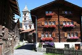
In 1998, the village was awarded the Wakker Prize for the preservation of its architectural heritage.
History
Vrin is first mentioned in 1208 as Varin.[2]
Geography


Vrin had an area, as of 2006, of 71.2 km2 (27.5 sq mi). Of this area, 39.3% is used for agricultural purposes, while 7.4% is forested. Of the rest of the land, 0.5% is settled (buildings or roads) and the remainder (52.9%) is non-productive (rivers, glaciers or mountains).[3]
The former municipality is located in the Lugnez sub-district of the Surselva district in the Upper Lugnez valley at the entrance to the Diesrut pass (source of the Glenner river) and near the Greina pass. It consists of the settlements of Vrin-dado (1,451 m (4,760 ft)), Vrin-dadens (main village), Cons, Ligiazun and Sogn Giusep. Additionally, a number of abandoned settlements are part of the municipality, including; Pignola (1,685 m (5,528 ft)), Puzzatsch, Foppa, Camplun, Vilegn, Schareida, Blengias and Vanescha.
Demographics
Vrin had a population (as of 2011) of 255.[4] As of 2008, 1.2% of the population was made up of foreign nationals.[5] Over the last 10 years the population has decreased at a rate of -13.2%. Most of the population (as of 2000) speaks Romansh (95.6%), with German being second most common ( 4.0%) and Polish being third ( 0.4%).[3]
As of 2000, the gender distribution of the population was 52.6% male and 47.4% female.[6] The age distribution, as of 2000, in Vrin is; 38 children or 15.3% of the population are between 0 and 9 years old and 25 teenagers or 10.0% are between 10 and 19. Of the adult population, 21 people or 8.4% of the population are between 20 and 29 years old. 37 people or 14.9% are between 30 and 39, 26 people or 10.4% are between 40 and 49, and 24 people or 9.6% are between 50 and 59. The senior population distribution is 38 people or 15.3% of the population are between 60 and 69 years old, 28 people or 11.2% are between 70 and 79, there are 10 people or 4.0% who are between 80 and 89,and there are 2 people or 0.8% who are between 90 and 99.[5]
In the 2007 federal election the most popular party was the CVP which received 45.1% of the vote. The next three most popular parties were the SVP (29.7%), the FDP (18.2%) and the SP (7%).[3]
In general, the Swiss population is well educated. In Vrin about 39.5% of the population (between age 25-64) have completed either non-mandatory upper secondary education or additional higher education (either university or a Fachhochschule).[3]
Vrin has an unemployment rate of 0.61%. As of 2005, there were 67 people employed in the primary economic sector and about 27 businesses involved in this sector. 19 people are employed in the secondary sector and there are 5 businesses in this sector. 30 people are employed in the tertiary sector, with 9 businesses in this sector.[3]
The historical population is given in the following table:[2][6]
| year | population |
|---|---|
| 1850 | 466 |
| 1900 | 366 |
| 1950 | 441 |
| 1960 | 393 |
| 1970 | 333 |
| 1980 | 266 |
| 1990 | 251 |
| 2000 | 249 |
Wakker Prize
Vrin was awarded the Wakker Prize for their integration of modern agricultural buildings into a traditional, historic village.[7] The prize recognizes a project that the village has been involved in for a number of years.
Throughout the 20th Century, the village population has steadily decreased. In the 1980s and 90's, Vrin entered a partnership between the village, the Cantonal historic preservation department and ETH Zürich to strengthen the village's infrastructure and lead to population growth.[8]
In the 1980s the residents of the village purchased all the free construction land to prevent land speculation and resultant price increases. The local architect, Gion A. Caminada, was hired to oversee construction.
Meadows were cleared, a butcher was brought in, a cooperative was founded and a slaughterhouse, barns and multi-purpose hall were all added. Most of the structures were built from wood in a log cabin style.[9] .[10]
Heritage sites of national significance
The Church of S. Maria is listed as a Swiss heritage site of national significance.[11]
The Church of the Immaculate Conception (St. Maria) and John the Baptist was consecrated in 1345. Until 1597 it was a chapel under the authority of the parish church of St. Vincenz in Pleif (part of the municipality of Vella).[2]
Weather
Vrin has an average of 121.1 days of rain or snow per year and on average receives 1,143 mm (45.0 in) of precipitation. The wettest month is August during which time Vrin receives an average of 139 mm (5.5 in) of rain or snow. During this month there is precipitation for an average of 12.7 days. The month with the most days of precipitation is July, with an average of 12.9, but with only 131 mm (5.2 in) of rain or snow. The driest month of the year is February with an average of 59 mm (2.3 in) of precipitation over 12.7 days.[12]
References
- ↑ Amtliches Gemeindeverzeichnis der Schweiz published by the Swiss Federal Statistical Office (German) accessed 2 January 2013
- 1 2 3 Vrin in German, French and Italian in the online Historical Dictionary of Switzerland.
- 1 2 3 4 5 Swiss Federal Statistical Office accessed 25-Nov-2009
- ↑ Swiss Federal Statistics Office – STAT-TAB Ständige und Nichtständige Wohnbevölkerung nach Region, Geschlecht, Nationalität und Alter (German) accessed 3 October 2012
- 1 2 Graubunden Population Statistics (German) accessed 21 September 2009
- 1 2 Graubunden in Numbers (German) accessed 21 September 2009
- ↑ Swiss Heritage Society (German) accessed 25 November 2009
- ↑ Vrin - Gesamtentwicklung eines Dorfes, Infoservice alpMedia (Gion A. Caminada) (German)
- ↑ Ausstellung zur Stiva da morts von Gion A. Caminada – Der Totenstube geweiht, ETH Life, 15. Januar 2003 (German)
Ausstellung: Stiva da morts, Gion A. Caminada, Vrin, Institut GTA, ETH Zürich, 16. Januar 2003 bis 20. März 2003 (German) - ↑ Zwei Dörfer – unterschiedliche Probleme (Vals und Vrin), ETH Zürich, Assistenzprof. Gion A. Caminada, 2000 (German)
- ↑ Swiss inventory of cultural property of national and regional significance 21.11.2008 version, (German) accessed 25-Nov-2009
- ↑ "Temperature and Precipitation Average Values-Table, 1961-1990" (in German, French, and Italian). Federal Office of Meteorology and Climatology - MeteoSwiss. Retrieved 8 May 2009., the weather station elevation is 1458 meters above sea level.
External links
| Wikimedia Commons has media related to Vrin. |
- Official website (German)
- Vrin in German, French and Italian in the online Historical Dictionary of Switzerland.