Vrhovo
| Vrhovo | |
|---|---|
 | |
 Vrhovo Location in Slovenia | |
| Coordinates: 46°2′22.37″N 15°13′16.73″E / 46.0395472°N 15.2213139°ECoordinates: 46°2′22.37″N 15°13′16.73″E / 46.0395472°N 15.2213139°E | |
| Country |
|
| Traditional region | Lower Carniola |
| Statistical region | Lower Sava |
| Municipality | Radeče |
| Area | |
| • Total | 1.95 km2 (0.75 sq mi) |
| Elevation | 194.3 m (637.5 ft) |
| Population (2002) | |
| • Total | 254 |
| [1] | |
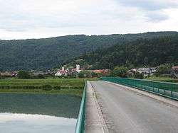
Vrhovo (pronounced [ʋəɾˈxɔːʋɔ] or [ʋəɾˈxoːʋɔ]; German: Werchou[2]) is a village on the right bank of the Sava River in the Municipality of Radeče in eastern Slovenia. The area is part of the historical region of Lower Carniola. The municipality is now included in the Lower Sava Statistical Region; until January 2014 it was part of the Savinja Statistical Region.[3]
The local church is dedicated to Saint Martin and belongs to the Parish of Radeče.[4]
References
- ↑ Statistical Office of the Republic of Slovenia
- ↑ Leksikon občin kraljestev in dežel zastopanih v državnem zboru, vol. 6: Kranjsko. 1906. Vienna: C. Kr. Dvorna in Državna Tiskarna, p. 88.
- ↑ Radeče municipal site
- ↑ "EŠD 2199". Registry of Immovable Cultural Heritage (in Slovenian). Ministry of Culture of the Republic of Slovenia. Retrieved 20 May 2011.
External links
 Media related to Vrhovo at Wikimedia Commons
- Vrhovo at Geopedia
| Settlements | Administrative centre: Radeče
|  | ||||||
|---|---|---|---|---|---|---|---|---|
| Landmarks |
| |||||||
This article is issued from Wikipedia - version of the 1/10/2016. The text is available under the Creative Commons Attribution/Share Alike but additional terms may apply for the media files.