Vranjina
| Native name: <span class="nickname" ">Врањина | |
|---|---|
 | |
| Geography | |
| Location | Lake Skadar |
| Coordinates | 42°16′27″N 19°08′08″E / 42.2742°N 19.1356°ECoordinates: 42°16′27″N 19°08′08″E / 42.2742°N 19.1356°E |
| Length | 1 km (0.6 mi) |
| Width | 2 km (1.2 mi) |
| Highest elevation | 330 m (1,080 ft) |
| Administration | |
| Demographics | |
| Population | 218 (2003) |
| Ethnic groups | Montenegrins, Serbs |
Vranjina (BCS: Vrnjina/Vranjina/Врањина; Albanian: Vraninë/Vranina[1]) is an island in Skadar Lake in the Montenegrin municipality of Podgorica. Vranjina is also the village on the island. Until the first half of the 18th century Vranjina, like other islands of Skadar lake, was one of the hills in the Zeta—Skadar lowlands.[2]
About the island
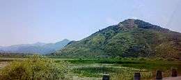
Created by a delta of the Morača River, the island is in the northern part of the lake. It has an area of 4.6 km2 and its highest point is at 296 meters, making it the highest island in Montenegro.
The island is connected to the mainland by a bridge, towards Podgorica, and a causeway, across the lake towards Bar.
A Serbian Orthodox monastery Vranjina is a well-known feature on the island. According to the legend, the island had different name before the monastery has been built. When Ilarion Šišojević, the first metropolitan bishop of the Zetan Orthodox Metropolitanate, started the construction of the monastery he decided that the island will be named against the first bird he would notice. It was a crow (Serbian: Врана).[3]
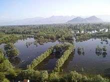
Vranjina town, on the shores of the Skadar lake, is called the Montenegrin Venice because of its natural setting. It is a popular fishing spot. Several fish restaurants located on the island include Plantaže restaurant.
A notable local landmarks include the so-called "house of Oso Kuka", named after an Ottoman border guard of Albanian descent who died at the island struggling against Montenegrin forces in 1862.
Sources
- ↑ Fishta, Gjergj (2006-03-03). "Glossary". In Robert Elsie. The Highland Lute. I.B.Tauris. p. 470. ISBN 9781845111182. Retrieved 28 January 2013.
- ↑ Ratko Đurović (1969). Crnom Gorom. "Binoza," Grafički zavod Hrvatske. p. 125. Retrieved 27 July 2013.
Ona predstavljaju uzvišenja u nekadašnjoj Zetsko-skadarskoj površi. Vranjina je, na primjer, postala ostrvo u prvoj polovini XIII vijeka, dok je prije toga bila dio kopna, kao i druga ostrva Skadarskog jezera.
- ↑ Glasnik Srpskoga učenog društva ... 1870. p. 167. Retrieved 22 June 2013.
| Wikimedia Commons has media related to Vranjina. |
| Urban municipalities |  | |
|---|---|---|
| Neighborhoods | ||
| Municipality settlements | Arza • Balabani • Baloči • Barlaj • Begova Glavica • Bezjovo • Benkaj • Beri • Berislavci • Bigor • Bijelo Polje • Bioče • Bistrice • Blizna • Bolesestra • Botun • Brežine • Briđe • Brskut • Budza • Buronji • Velje Brdo • Veruša • Vidijenje • Vilac • Vladni • Vranj • Vranjina • Vrbica • Vukovci • Vuksanlekići • Golubovci • Goljemadi • Goričani • Gornje Stravče • Gornji Kokoti • Gornji Milješ • Gostilj • Gradac • Grbavci • Grbi Do • Gurec • Delaj • Dinoša • Dolovi • Donje Stravče • Donji Kokoti • Donji Milješ • Draževina • Drešaj • Drume • Duga • Dučići • Dušići • Duške • Đurkovići • Zagreda • Zaugao • Kiselica • Klopot • Kopilje • Kornet • Kosor • Kotrabudan • Koći • Kržanja • Kruse • Krševo • Kurilo • Lekići • Lijeva Rijeka • Liješnje • Liješta • Lovka • Lopate • Lužnica • Lutovo • Ljajkovići • Mataguži • Mahala • Medun • Mileti • Mitrovići • Mojanovići • Momče • Mrke • Mužeška • Nabon • Nikmaraš • Ožezi • Omerbožovići • Opasanica • Oraovice • Orasi • Orahovo • Parci • Pelev Brijeg • Petrovići • Pikalj • Podgorica • Podhum • Ponari • Poprat • Prisoja • Prifti • Progonovići • Radeća • Radovče • Rakića Kuće • Raći • Releza • Rijeka Piperska • Rudine • Selište • Seoca • Seoštica • Sjenice • Skorać • Slacko • Spinja • Srpska • Staniselići • Stanjevića Rupa • Stijena • Stjepovo • Stupovi • Sukuruć • Trabojin • Trmanje • Tuzi • Tuzi Ljevorečke • Ćafa • Ćepetići • Ubalac • Ubli • Farmaci • Fundina • Helmnica • Cvilin • Cijevna • Crvena Paprat • Crnci • Šušunja | |
| Geography | ||
| Landmarks | ||
| Culture | ||
| Sports venues |
| |
| Sport clubs | ||
| Events | ||
| Education | ||
| Media |
| |
| Shopping malls | ||
| Companies | ||
| Transportation | ||