Volga, South Dakota
| Volga, South Dakota | |
|---|---|
| City | |
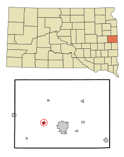 Location in Brookings County and the state of South Dakota | |
| Coordinates: 44°19′19″N 96°55′28″W / 44.32194°N 96.92444°WCoordinates: 44°19′19″N 96°55′28″W / 44.32194°N 96.92444°W | |
| Country | United States |
| State | South Dakota |
| County | Brookings |
| Incorporated | 1903[1] |
| Area[2] | |
| • Total | 0.91 sq mi (2.36 km2) |
| • Land | 0.91 sq mi (2.36 km2) |
| • Water | 0 sq mi (0 km2) |
| Elevation | 1,634 ft (498 m) |
| Population (2010)[3] | |
| • Total | 1,768 |
| • Estimate (2015)[4] | 1,865 |
| • Density | 1,942.9/sq mi (750.2/km2) |
| Time zone | Central (CST) (UTC-6) |
| • Summer (DST) | CDT (UTC-5) |
| ZIP code | 57071 |
| Area code(s) | 605 |
| FIPS code | 46-67700 |
| GNIS feature ID | 1258770[5] |
| Website |
www |
Volga is a city in Brookings County, South Dakota, United States with a population of 1,768 at the 2010 census.
History
Volga was founded by the Western Town Lot Company on December 27, 1879 by Col. Arthur Jacoby. It was originally named "Bandy Town" after the Bandy family, early settlers there. Later, in 1880, the railroad assigned it the name "Volga", after the Volga River, in Russia.[6][7] Volga is talked about in the juvenile novel The Long Winter by Laura Ingalls Wilder in the chapter titled "Pa Goes to Volga".
Geography
Volga is located at 44°19′19″N 96°55′28″W / 44.32194°N 96.92444°W (44.321994, -96.924565).[8]
According to the United States Census Bureau, the city has a total area of 0.91 square miles (2.36 km2), all of it land.[2]
Volga has been assigned the ZIP code 57071 and the FIPS place code 67700.
Demographics
| Historical population | |||
|---|---|---|---|
| Census | Pop. | %± | |
| 1880 | 287 | — | |
| 1890 | 298 | 3.8% | |
| 1900 | 396 | 32.9% | |
| 1910 | 568 | 43.4% | |
| 1920 | 600 | 5.6% | |
| 1930 | 604 | 0.7% | |
| 1940 | 632 | 4.6% | |
| 1950 | 578 | −8.5% | |
| 1960 | 780 | 34.9% | |
| 1970 | 982 | 25.9% | |
| 1980 | 1,221 | 24.3% | |
| 1990 | 1,263 | 3.4% | |
| 2000 | 1,435 | 13.6% | |
| 2010 | 1,768 | 23.2% | |
| Est. 2015 | 1,865 | [9] | 5.5% |
| U.S. Decennial Census[10] 2015 Estimate[4] | |||
2010 census
As of the census[3] of 2010, there were 1,768 people, 734 households, and 483 families residing in the city. The population density was 1,942.9 inhabitants per square mile (750.2/km2). There were 783 housing units at an average density of 860.4 per square mile (332.2/km2). The racial makeup of the city was 98.2% White, 0.3% African American, 0.4% Native American, 0.3% Asian, 0.3% from other races, and 0.5% from two or more races. Hispanic or Latino of any race were 2.7% of the population.
There were 734 households of which 32.7% had children under the age of 18 living with them, 53.5% were married couples living together, 7.9% had a female householder with no husband present, 4.4% had a male householder with no wife present, and 34.2% were non-families. 28.5% of all households were made up of individuals and 11% had someone living alone who was 65 years of age or older. The average household size was 2.41 and the average family size was 2.98.
The median age in the city was 33.8 years. 26.5% of residents were under the age of 18; 7.7% were between the ages of 18 and 24; 30.2% were from 25 to 44; 22.2% were from 45 to 64; and 13.5% were 65 years of age or older. The gender makeup of the city was 49.2% male and 50.8% female.
2000 census
As of the census of 2000, there were 1,435 people, 571 households, and 413 families residing in the city. The population density was 1,862.1 people per square mile (719.6/km²). There were 596 housing units at an average density of 773.4 per square mile (298.9/km²). The racial makeup of the city was 98.75% White, 0.42% Native American, 0.21% Asian, and 0.63% from two or more races. Hispanic or Latino of any race were 0.42% of the population.
There were 571 households out of which 37.1% had children under the age of 18 living with them, 61.5% were married couples living together, 8.9% had a female householder with no husband present, and 27.5% were non-families. 24.7% of all households were made up of individuals and 11.2% had someone living alone who was 65 years of age or older. The average household size was 2.51 and the average family size was 3.03.
In the city the population was spread out with 27.9% under the age of 18, 7.8% from 18 to 24, 30.8% from 25 to 44, 20.7% from 45 to 64, and 12.8% who were 65 years of age or older. The median age was 34 years. For every 100 females there were 92.9 males. For every 100 females age 18 and over, there were 90.3 males.
As of 2000 the median income for a household in the city was $41,818, and the median income for a family was $51,131. Males had a median income of $31,083 versus $23,190 for females. The per capita income for the city was $18,237. About 3.4% of families and 6.2% of the population were below the poverty line, including 10.1% of those under age 18 and 8.7% of those age 65 or over.
Tourism

Old Timer's Day in Volga occurs in the first week of June every year and is capped off by an over-21-only street dance and many private parties.
The Brookings County Historical Museum is located in Volga, as well as a home of an early settler by the city park.[11]
Education
Public schools
Volga is served by the Sioux Valley School District. The district has one elementary school, one middle school, and one high school. Students attend Sioux Valley High School. Three communities are included in the Sioux Valley school system: Bruce, Sinai, and Volga.[12]
Private schools
Volga also has a private K through 8th school called the Volga Christian School.
Notable people
- Del Paddock, Major League Baseball player
See also
References
- ↑ "SD Towns" (PDF). South Dakota State Historical Society. Retrieved 2010-02-16.
- 1 2 "US Gazetteer files 2010". United States Census Bureau. Archived from the original on January 24, 2012. Retrieved 2012-06-21.
- 1 2 "American FactFinder". United States Census Bureau. Retrieved 2012-06-21.
- 1 2 "Population Estimates". United States Census Bureau. Retrieved June 7, 2016.
- ↑ "US Board on Geographic Names". United States Geological Survey. 2007-10-25. Retrieved 2008-01-31.
- ↑ "Volga Community Profile" (PDF). www.volgacity.com. Retrieved 2010-03-28. External link in
|work=(help) - ↑ Anonymous Compiler (1908). A History of the Origin of the Place Names. The Chicago & North Western Railroad and Chicago, St. Paul, Minneapolis & Railroad. p. 134.
- ↑ "US Gazetteer files: 2010, 2000, and 1990". United States Census Bureau. 2011-02-12. Retrieved 2011-04-23.
- ↑ "Annual Estimates of the Resident Population for Incorporated Places: April 1, 2010 to July 1, 2015". Retrieved July 2, 2016.
- ↑ United States Census Bureau. "Census of Population and Housing". Archived from the original on May 11, 2015. Retrieved July 20, 2014.
- ↑ http://brookingscomuseum.tripod.com/id1.html
- ↑ "Sioux Valley Schools". Sioux Valley Schools. Retrieved August 5, 2012.
External links
Municipalities and communities of Brookings County, South Dakota, United States | ||
|---|---|---|
| Cities | 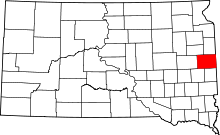 | |
| Towns | ||
| CDP | ||
| Other unincorporated communities | ||
| Townships |
| |
| Footnotes | ‡This populated place also has portions in an adjacent county or counties | |