Vistula Lagoon
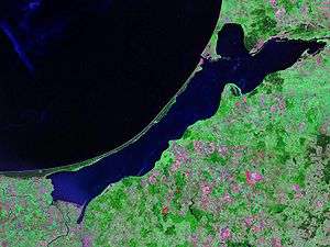
The Vistula Lagoon (Polish: Zalew Wiślany; Russian: Калининградский залив or Kaliningradskiy Zaliv; German: Frisches Haff; Lithuanian: Aistmarės) is a brackish water lagoon on the Baltic Sea roughly 56 miles (90 km) long, 6 to 15 miles (10 to 19 km) wide, and up to 17 feet (5 m) deep, separated from Gdańsk Bay by the Vistula Spit. It is now known as the Vistula Bay or Vistula Gulf. The modern German name, Frisches Haff, is derived from an earlier form, Friesisches Haff.[1]
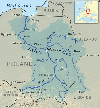
The lagoon is a mouth of a few branches of the Vistula River, notably the Nogat, and the Pregolya River. It is connected to Gdańsk Bay by the Strait of Baltiysk.
The Poland–Russia border runs across the lagoon.
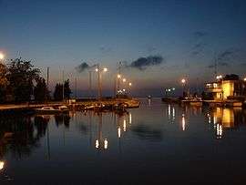
Localities on the lagoon include Kaliningrad, Baltiysk, and Primorsk in Russia's Kaliningrad Oblast and Elbląg, Tolkmicko, Frombork, Krynica Morska in Poland. The Polish port of Elbląg used to see a substantial amount of trading traffic on the lagoon, but that has declined owing to the current border situation. Kaliningrad and Baltiysk are currently major seaports on the lagoon.
Etymology
The earliest version of the name of Vistula Lagoon has been recorded in historical sources by Wulfstan, an Anglo-Saxon sailor and merchant at the end of the 9th Century as Estmere.[2] It is an Anglo-Saxon translation of Old Prussian name for the lagoon - *Aīstinmari (modern Lithuanian - Aistmarės) derived from (OP - Old Prussian) Aistei - "Ests", (LAT - Latin)"Aestii" etc. and (OP) *mari - "lagoon (a body of water cut off from a larger body by a reef of sand), fresh water bay".[3] The Ests were Baltic people who since 9th Century became called in some historical sources (first time by Bavarian Geographer) Bruzi, Pruzzen, Pruteni etc. - Old Prussians. So the oldest known meaning of the name of Vistula Lagoon was "The lagoon or sea of the Ests". Over three hundred years later, in the first half of the 13th Century, the name of Vistula Lagoon occurs in deeds issued by Teutonic Order in Latin version as Mare Recens (1246 - "mare" - a pool or lake or sea and "recens" - fresh) in contrast to the contemporary name for the Baltic Sea - Mare Salsum (Salty Sea). Then in 1251 we find record about Mare Recens et Neriam (Frisches Haff and Frische Nehrung, now Vistula Spit) and finally in 1288 Recenti Mari Hab (Haff) which as one can see corresponds with later German "Frisches Haff" = "Fresh Lagoon".[4]
Proposed Canal
Digging a canal to connect the lagoon with the Baltic Sea is in consideration as a major EU-supported project. The canal, would re-activate the Elbląg river port. It would also free its dependence on Russia, which time and again revokes the right of passage for Polish ships through Strait of Baltiysk as a form of pressure on Polish authorities.
In October 2016 details of the project were confirmed by PiS leader, Jarosław Kaczyński. The 1.3 kilometres (0.81 mi) long, 80 metres wide and 5 metres deep canal shall be completed by 2020 at an estimated cost of PLN 880 million.[5] However, major ecological considerations stand in the way. For example, mammal migration along the lagoon could be disrupted. Also, the inflow of brackish waters from the Baltic sea could result in serious unbalancing of the lagoon's freshwater ecosystem.
History
From 1772 until 1918, the lagoon was part of the Kingdom of Prussia, which had become part of the German Empire in 1871. Between 1920 and 1946 it was split between Germany and the Free City of Danzig. At present state since 1945 its eastern part belongs to Russia (formerly USSR), Poland has 43.8% of its area at lagoon's western side. The bordering administrative regions is polish Warmian-Masurian Voivodeship and modern Russian Kaliningrad Oblast, which had name Königsberg Oblast during half of 1946.
Kursenieki

While today the Kursenieki, also known as Kuršininkai are a nearly extinct Baltic ethnic group living along the Curonian Spit, in 1649 Kuršininkai settlement spanned from Memel (Klaipėda) to Danzig (Gdańsk), including the area around the Vistula Lagoon. The Kuršininkai were eventually assimilated by the Germans, except along the Curonian Spit where some still live. The Kuršininkai were considered Latvians until after World War I when Latvia gained independence from the Russian Empire, a consideration based on linguistic arguments. This was the rationale for Latvian claims over the Curonian Spit, Memel, and other territories of East Prussia which would be later dropped.
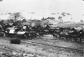
Historical events related to lagoon
From January until March 1945 throughout the Evacuation of East Prussia refugees from East Prussia crossed the frozen lagoon on their way to the west after the Red Army had reached the coast of the lagoon near Elbing on January 26. Attacked by Soviet fighter aircraft thousands of them were killed or broke through the ice.
See also
References
- ↑ Erhard Riemann, Alfred Schoenfeldt, Ulrich Tolksdorf, Reinhard Goltz, Akademie der Wissenschaften und der Literatur (Germany), Akademie der Wissenschaften und der Literatur, Mainz, Preussisches Wörterbuch: Deutsche Mundarten Ost- und Westpreussens, 6th edition, Wachholtz, 1974, p.595, ISBN 3-529-04611-6
- ↑ Janet Batley, Wulfstan's voyage and his description of Estland: the text and the language of the text, in: Wulfstan's Voyage. The Baltic Sea region in the early Viking Age as seen from shipboard, Maritime Culture of the North, 2, Roskilde 2009, p. 15.
- ↑ Mikkels Klussis, Dictionary of revived Prussian: Prussian - English, English - Prussian, Vilnus 2005/06, p. 47.
- ↑ Codex diplomaticus Warmiensis oder Regesten und Urkunden zur Geschichte Ermlands. Bd. 1, Urkunden der Jahre 1231-1340, (ed.) Johann Martin Saage, Carl Peter Woelky, Mainz 1860, No. 13, p. 18 - 22, No. 26, p. 46 - 49, No. 79, p. 133 - 136.
- ↑ "Poland to Spend Quarter Billion Dollars on Canal 'to Break Off With Russia'". Sputnik News. 15 October 2016. Retrieved 15 October 2016.
External links
- www.en.zalew-wislany.pl – Monitoring the Vistula Lagoon water quality on the basis of satellite remote sensing
- Battle of Vistula Lagoon
| Wikimedia Commons has media related to Vistula Lagoon. |
Coordinates: 54°27′N 19°45′E / 54.450°N 19.750°E
Tributaries of the Vistula River | ||
|---|---|---|
| Forming rivers |
|  |
| Main tributaries of the left bank | ||
| Main tributaries of the right bank |
| |
| Distributary | ||