Vista Ridge Tunnels
 The east end of the Vista Ridge Tunnels face downtown Portland and are under a residential neighborhood. | |
| Overview | |
|---|---|
| Location | Portland, Oregon, USA |
| Coordinates |
45°30′57″N 122°41′57″W / 45.5158°N 122.6991°WCoordinates: 45°30′57″N 122°41′57″W / 45.5158°N 122.6991°W (west) 45°30′56″N 122°41′41″W / 45.5156°N 122.6948°W (east) |
| Status | operational |
| Route |
|
| Operation | |
| Opened | 1969–1970 |
| Owner | Oregon Department of Transportation |
| Traffic | Automotive |
| Character | Limited access highway |
| Technical | |
| Number of lanes | 6, 3 in each bore |
| Operating speed | 50 mph (80 km/h) |
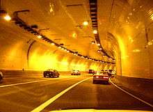
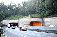
The Vista Ridge Tunnels are highway tunnels through the Tualatin Mountains ("West Hills") of Portland, Oregon, United States. Located in the Goose Hollow neighborhood,[1] the tunnels pass through a hillside locally known as Vista Ridge which is a half mile (1 km) west of downtown Portland. Sunset Highway, also known as U.S. Route 26, is carried through the tunnels, three lanes in each direction. They are Oregon's busiest tunnels.
The eastbound tunnel is 1001.0 feet (305 m) in length; the westbound tunnel is 949 feet (289 m). Both have 41 ft (12.5 m) of horizontal and 15.58 ft (4.75 m) of vertical clearance. The eastbound tunnel was completed in 1969, the westbound a year later.[2][3]
There is a six-percent grade through the tunnels. Most of the tunnels' lengths are straight, though they curve southward at the west ends 35°.[4]
The tunnels were built with ventilation shafts which were never used. Instead, the shafts were later adapted for electrical wiring, so as to improve tunnel illumination without marring the tunnels' appearance with visible conduit.[5]
To improve tunnel safety for motorists, and decrease the tunnel lighting requirements, the original tunnel entrance faces were sandblasted to remove white paint and repainted a less luminescent tan color to reduce the range of visual light adaptation required by drivers. At one time there were computer-based electronic light controls, but they were replaced by relatively simple photo detectors and relays for durability and simplicity. The night lighting level is enabled permanently and is supplemented by two or three levels of daytime lighting.[5]
Except directly over the tunnels, the hillsides are steep and undeveloped forest, with some residential development along the top of the ridges. Landslides occasionally occur, but are usually minor and quickly cleared.[6]
The tunnels have been closed to hazardous material transport since November 1, 1994.[7] As a result, US 26 is closed to hazardous material transport between I-405 and Oregon Route 217.
The tunnels are located nearly at the bottom of a hill where the road gradient averages 6.5% over 2.25 mi (3.6 km). Close to the east portals is a 130-foot (40 m) tunnel underpass carrying SW 18th Avenue. Just outside the west portals is a 650-foot (200 m) tunnel under the lanes which carries eastbound Canyon Road[8] from the exit ramp into Goose Hollow. The Robertson Tunnel for MAX Light Rail is underground approximately 800 feet (250 m) to the west.
Traffic volume
They are the busiest tunnels in Oregon,[9] 12% busier than I-5's 6-lane Interstate Bridge, and 2% busier than I-205's 8+ lane Glenn L. Jackson Memorial Bridge.[10] They carry about 25–35 percent more traffic than New York's Lincoln Tunnel[11] which claims to be one of the busiest tunnels in the world.[12]
| Year | Average Daily Traffic Volume |
|---|---|
| 1986 | 102,300[13] |
| 1996 | 128,700[14] or 142,950[15] |
| 1997 | 131,100[16] or 143,615[15] |
| 1998 | 130,200[17] or 143,897[15] |
| 1999 | 132,600[18] or 145,299[15] |
| 2000 | 134,400[19] |
| 2001 | 135,200[20] |
| 2002 | 136,000[21] |
| 2003 | 136,000[22] |
| 2005 | 139,325[23] |
| 2006 | 141,633[23] |
| 2007 | 141,408[23] |
| 2008 | 137,150[23] |
| 2009 | 139,800[23] |
| 2010 | 138,369[23] |
| 2011 | 138,937[23] |
| 2012 | 139,387[23] |
| 2013 | 140,605[23] |
| 2014 | 140,639[23] |
See also
References
- ↑ Prince, Tracy J. (2011). Portland's Goose Hollow. Charleston, South Carolina: Arcadia Publishing. p. 2. ISBN 978-0-7385-7472-1.
- ↑ "Vista Ridge Tunnel (#9103+047+07353)". Historic Bridges of the United States. Retrieved 2007-07-30.
- ↑ Updated August 1999 by Rosalind Keeney, ODOT Cultural Resource Specialist; Revised September 2002 by Robert W. Hadlow, Ph.D., ODOT Historian (September 2002). "Appendix A: Highway Tunnels of Oregon" (PDF). Oregon Department of Transportation. Retrieved 2007-08-04.
- ↑ Determined by rotating satellite image with Photoshop.
- 1 2 Jim Degnan, P.E. (October 2005). "Tunnel Lighting" (PDF). Roads and Bridges. Sparling electrical engineering and technology consulting. Archived from the original (PDF) on 2007-09-28. Retrieved 2007-08-04.
- ↑ "News Release: Landslide Repair Work Closes Westbound U.S. 26". Oregon Department of Transportation. April 13, 2007. Retrieved 2007-08-04.
- ↑ "Transportation of Hazardous Materials; Designated, Preferred, and Restricted Routes". Federal Register: December 4, 2000 (Volume 65, Number 233). U.S. Department of Transportation, Federal Motor Carrier Safety Administration. December 4, 2000. pp. 75771–75816. Retrieved 2007-07-30.
- ↑ Before the Sunset Highway was built, the two lane Canyon Road extended into Goose Hollow. Street signs near the Vista Bridge indicate the junction of SW Jefferson Street and SW Canyon Road.
- ↑ Oregon Department of Transportation—Bridge Engineering Section (April 2007). "2008-2011 Draft Statewide Transportation Improvement Program—Evaluation of the State Bridge Program" (PDF). pp. 26 (25 on page). Retrieved 2012-11-26.
- ↑ Glenn L. Jackson Memorial Bridge carries 137,000 average daily traffic; the Interstate Bridge, 124,500. Obtained 2004 values from "Average Daily Traffic on Oregon's Interstate Highways 1954–2004" (PDF). Oregon Department of Transportation. May 10, 2006. pp. 2, 4. Retrieved 2007-08-29.
- ↑ Lincoln Tunnel's average daily traffic is consistently around 100,000.
- ↑ "The Helix Fix – The Lincoln Tunnel Helix Rehabilitation Project". The Port Authority of New York and New Jersey. Retrieved 2012-11-26.
- ↑ Oregon Department of Transportation (1987). "1986 Traffic Volumes on State Highways" (PDF). p. 50. Retrieved 2012-11-26.
- ↑ Oregon Department of Transportation (2004-10-27). "1996 Traffic Volumes on State Highways" (PDF). p. 83. Retrieved 2012-11-26.
- 1 2 3 4 This value is an average of week day usage for May; the ODOT value is a year long average. Oregon Transportation Institute (November 5, 1999). "Analysis of the Westside Corridor Travel Study—Did Westside Light Rail Really Reduce Traffic Volumes?". Archived from the original on 2008-02-13. Retrieved 2007-08-04.
- ↑ Oregon Department of Transportation (2004-10-27). "1997 Traffic Volumes on State Highways" (PDF). p. 82. Retrieved 2012-11-26.
- ↑ Oregon Department of Transportation (2004-10-29). "1998 Traffic Volumes on State Highways" (PDF). p. 92. Retrieved 2012-11-26.
- ↑ Oregon Department of Transportation (2004-10-28). "1999 Traffic Volumes on State Highways" (PDF). p. 83. Retrieved 2012-11-25.
- ↑ Oregon Department of Transportation (2004-10-28). "2000 Traffic Volumes on State Highways" (PDF). p. 84. Retrieved 2012-11-25.
- ↑ Oregon Department of Transportation (2004-10-26). "2001 Traffic Volumes on State Highways" (PDF). p. 63. Retrieved 2012-11-25.
- ↑ Oregon Department of Transportation (2004-10-25). "2002 Traffic Volumes on State Highways" (PDF). p. 63. Retrieved 2012-11-25.
- ↑ Oregon Department of Transportation (2004-10-20). "2003 Traffic Volumes on State Highways" (PDF). pp. 60 (84 on page). Retrieved 2012-11-25.
- 1 2 3 4 5 6 7 8 9 10 Oregon Department of Transportation (2015-09-10). "2014 Traffic Volumes on State Highways" (PDF). pp. 291 (289 on page). Retrieved 2016-03-27.