Virginia's congressional districts

Virginia is currently divided into 11 congressional districts, each represented by a member of the United States House of Representatives. The number of Virginia's districts remained unchanged after the 2010 Census.
2016 Redistricting

The Virginia Legislature's 2012 redistricting was found unconstitutional and replaced with a court-ordered redistricting on January 16 2016 for the 2016 elections. [2][3][4][5][6] Gloria Personhuballah and James Farkas claimed that Virginia’s 3rd Congressional District violated the Voting Rights Act by packing black voters into the district for the political purpose of making surrounding areas better for Republican candidates. Following Supreme Court precedent, the Eastern Virginia Circuit Court found that U.S. Congressional Districts cannot be gerrymandered for partisan gain. In this case, the twisting non-contiguous 3rd District hopped the James River in several places and divided multiple locality boundaries, resulting in 89% majorities for black Representative Bobby Scott (D) while surrounding Republican incumbents enjoyed majorities of 16-24%. Subsequent appeals by Republican lawmakers to the Supreme Court were unsuccessful.[7]
Bipartisan gerrymandering
Virginia is one of the most gerrymandered states in the country both on the congressional and state levels based on lack of compactness and contiguity of its districts. Virginia Congressional Districts are ranked the 5th worst in the country because counties and cities are broken into multiple pieces to create heavily partisan districts.[8]
Virginia’s Congressional districts do not meet the “competitive” mark of a 5% margin of victory, but they average a margin of 35% comparable to the national district statistical average of all 435 districts. Districts 10 and 11 in northern Virginia and the 2nd in the Hampton Roads ranged between 16-18%. Virginia, like the nation as a whole has about 73% of its delegation winning by a margin of 20% or more. Districts 4, 7, 5, 1 and 8 ranged from 22-32%, and three outliers had a margin of victory of over 50%: the 9th at 48%, the 6th at 62% and the 3rd at 89%.[9]
See Recent and present district boundaries below.
Reform efforts
Reform recommendations by the Redistricting Coalition of Virginia include either an independent commission or a bipartisan commission that is not polarized. Member organizations include the League of Women Voters of Virginia, AARP of Virginia, OneVirginia2021, the Virginia Chamber of Commerce and the Virginia Organizing Project.[10]
The Independent Bipartisan Advisory Commission on Redistricting for the Commonwealth of Virginia made its report on April 1, 2011. It made recommendations for both state legislative and congressional district redistricting, detailing three options for congressional districts, all improving on the 2001 Congressional map by reducing the number of split jurisdictions, describing three districts in the DC metro northern Virginia area, and increasing compactness in each district. In accordance with the Voting Rights Act, it maintained one majority African-American district without packing to dilute community influence in other districts.[11]
In 2011, the Virginia College and University Redistricting Competition was organized by Professors Michael McDonald of George Mason University and Quentin Kidd of Christopher Newport University. About 150 students on sixteen teams from thirteen schools submitted plans for legislative and U.S. Congressional Districts. The winning submissions for the Congressional redistricting were from the University of Virginia and from the college of William and Mary. The “Division 1” maps conformed with the Governor’s Executive Order, and did not address electoral competition or representational fairness. In addition to the criteria of contiguity, equipopulation, the federal Voting Rights Act and communities of interest in the existing city and county boundaries, “Division 2” maps in the competition did incorporate considerations of electoral competition and representational fairness. Judges for the cash award prizes were Thomas Mann of the Brookings Institution and Norman Ornstein of the American Enterprise Institute. They also created districts more compact than the General Assembly’s earlier efforts.[12]
In January 2015, Republican State Senator Jill Holtzman Vogel of Winchester and Democratic State Senator Louise Lucas of Portsmouth sponsored a Senate Joint Resolution to establish additional criteria for the Virginia Redistricting Commission of four identified members of political parties, and three other independent public officials. The criteria began with respecting existing political boundaries, such as cities and towns, counties and magisterial districts, election districts and voting precincts. Districts are to be established on the basis of population, in conformance with federal and state laws and court cases, including those addressing racial fairness. The territory is to be contiguous and compact, without oddly shaped boundaries. The commission is prohibited from using political data or election results to favor either political party or incumbent. It passed with a two-thirds majority of 27 to 12 in the Senate, and was then referred to committee in the House of Delegates.[13]
Current districts and representatives
List of members of the Virginian United States House delegation, their terms, their district boundaries, and the districts' political rating according to the CPVI. The delegation has a total of 11 members, with 8 Republicans and 3 Democrats. The 3rd and 4th Districts of Virginia have been redrawn by U.S. District Court Order and sustained by the Supreme Court on appeal. See map at the subsection on 2016 redistricting above.
| District | Representative | Party | CPVI | Incumbency | District map |
|---|---|---|---|---|---|
| 1st |  Rob Wittman (R-Manassas) Rob Wittman (R-Manassas) |
Republican | R+8 | December 11, 2007 – present | .tif.png) |
| 2nd |  Scott Rigell (R-Virginia Beach) Scott Rigell (R-Virginia Beach) |
Republican | R+4 | January 3, 2011 – present | .tif.png) |
| 3rd |  Robert Scott (D-Newport News) Robert Scott (D-Newport News) |
Democratic | D+15 | January 3, 1993 – present | .tif.png) |
| 4th |  Randy Forbes (R-Chesapeake) Randy Forbes (R-Chesapeake)
Soon to be replaced by Donald McEachin on January 3, 2017 (D-Henrico County) |
Republican | D+8 | June 19, 2001 – January 3, 2017 | .tif.png) |
| 5th |  Robert Hurt (R-Chatham) Robert Hurt (R-Chatham) |
Republican | R+5 | January 3, 2011 – present | .tif.png) |
| 6th |  Bob Goodlatte (R-Roanoke) Bob Goodlatte (R-Roanoke) |
Republican | R+12 | January 3, 1993 – present | .tif.png) |
| 7th |  Dave Brat (R-Glen Allen) Dave Brat (R-Glen Allen) |
Republican | R+8 | November 4, 2014 – present | .tif.png) |
| 8th |  Don Beyer (D-Alexandria) Don Beyer (D-Alexandria) |
Democratic | D+16 | January 3, 2015 – present | .tif.png) |
| 9th |  Morgan Griffith (R-Salem) Morgan Griffith (R-Salem) |
Republican | R+15 | January 3, 2011 – present | .tif.png) |
| 10th |  Barbara Comstock (R-McLean) Barbara Comstock (R-McLean) |
Republican | R+2 | January 3, 2015 – present | .tif.png) |
| 11th |  Gerry Connolly (D-Fairfax) Gerry Connolly (D-Fairfax) |
Democratic | D+10 | January 3, 2009 – present | .tif.png) |
Historical background
Apportionment
Elections held in the year of a census use the apportionment determined by the previous census.
| 1789 | 1790 | 1800 |
|---|---|---|
| 10[14] | 19 | 22 |
| 1810 | 1820 | 1830 | 1840 | 1850 | 1860 | 1870 | 1880 | 1890 | 1900 |
|---|---|---|---|---|---|---|---|---|---|
| 23 | 22 | 21 | 15 | 13 | 11 | 9[15] | 10 | 10 | 10 |
| 1910 | 1920 | 1930 | 1940 | 1950 | 1960 | 1970 | 1980 | 1990 | 2000 |
|---|---|---|---|---|---|---|---|---|---|
| 10 | 10 | 9 | 9 | 10 | 10 | 10 | 10 | 11 | 11 |
| 2010 |
|---|
| 11 |
List of former and current districts
 Virginia Congressional delegation, 113th Congress, Republicans shown in red and Democrats in blue. Current Districts
|
Former districts
|
Recent and present district boundaries
Table of United States congressional district boundary maps in the State of Virginia, are presented chronologically below for the most recent iterations following the redistricting of the 1960s where the General Assembly was court-ordered to arrive at a one-man-one-vote formula.[27] All redistricting events that took place in Virginia between 1973 and 2013 are shown.
| Year | Statewide map | Norfolk highlight |
|---|---|---|
| 1973 – 1982 |  |
%2C_1973_%E2%80%93_1982.tif.png) |
| 1983 – 1992 | 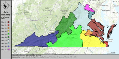 |
%2C_1983_%E2%80%93_1992.tif.png) |
| 1993 – 1994 |  |
%2C_1993_%E2%80%93_1994.tif.png) |
| 1995 – 1998 |  |
%2C_1995_%E2%80%93_1998.tif.png) |
| 1999 – 2002 | 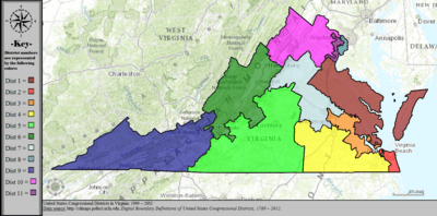 |
%2C_1999_%E2%80%93_2002.tif.png) |
| 2003 – 2013 | 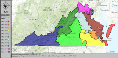 |
%2C_2003_%E2%80%93_2013.tif.png) |
| Since 2013 |  |
%2C_since_2013.tif.png) |
See also
References
- ↑ "The national atlas". nationalatlas.gov. Retrieved February 2, 2014.
- ↑ http://redistricting.dls.virginia.gov/2010/court-ordered-redistricting.aspx
- ↑ http://redistricting.dls.virginia.gov/2010/Data/Court%20Ordered%20Redistricting/2016%2001%2007%20Personnhuballah%20v%20Alcorn%20Civil%20Action%20No.%203-13cv678.pdf
- ↑ http://thehill.com/regulation/court-battles/273764-supreme-court-weighs-legality-of-virginia-redistricting
- ↑ http://www.rollcall.com/news/supreme_court_allows_virginia_redistricting_to_stand_in_2016-245689-1.html
- ↑ http://www.richmond.com/news/virginia/government-politics/article_0ad5053b-6818-5d7e-b96e-c9ce02ad45cb.html
- ↑ Supreme Court weighs legality of Virginia redistricting, The Hill online viewed October 16, 2016, Redistricting in Virginia, Ballotpedia, the Encyclopedia of American Politics, viewed October 14, 2016.
- ↑ One Virginia 2021: Virginians for fair redistricting viewed October 13, 2016.
- ↑ Redistricting in Virginia, Ballotpedia, the Encyclopedia of American Politics, viewed October 14, 2016.
- ↑ https://web.archive.org/web/20141010080238/http://fixthelines.org/CoalitionMembers/tabid/564/Default.aspx the virginia redistricting coalition] viewed October 13, 2016.
- ↑ The Public Interest in Redistricting Bob Holsworth, Chair for the Independent Bipartisan Advisory Commission on Redistricting, Commonwealth of Virginia, April 1, 2011, p.22-27.
- ↑ The Public Interest in Redistricting Bob Holsworth, Chair for the Independent Bipartisan Advisory Commission on Redistricting, Commonwealth of Virginia, April 1, 2011, p.9-10
- ↑ SENATE JOINT RESOLUTION NO. 284 AMENDMENT IN THE NATURE OF A SUBSTITUTE (Proposed by the Senate Committee on Privileges and Elections on January 20, 2015) (Patrons Prior to Substitute--Senators Vogel and Lucas [SJR 224])
- ↑ Represents apportionment assigned by the U.S. Constitution in 1789 until the first U.S. Census.
- ↑ West Virginia was formed out of portions of Virginia in 1863.
- ↑ US Census. "My Congressional District (estimates)". US Census. Retrieved 2014-04-21.
- ↑ US Census. "My Congressional District (estimates)". US Census. Retrieved 2014-04-21.
- ↑ US Census. "My Congressional District (estimates)". US Census. Retrieved 2014-04-21.
- ↑ US Census. "My Congressional District (estimates)". US Census. Retrieved 2014-04-21.
- ↑ US Census. "My Congressional District (estimates)". US Census. Retrieved 2014-04-21.
- ↑ US Census. "My Congressional District (estimates)". US Census. Retrieved 2014-04-21.
- ↑ US Census. "My Congressional District (estimates)". US Census. Retrieved 2014-04-21.
- ↑ US Census. "My Congressional District (estimates)". US Census. Retrieved 2014-04-21.
- ↑ US Census. "My Congressional District (estimates)". US Census. Retrieved 2014-04-21.
- ↑ US Census. "My Congressional District (estimates)". US Census. Retrieved 2014-04-21.
- ↑ US Census. "My Congressional District (estimates)". US Census. Retrieved 2014-04-21.
- ↑ "Digital Boundary Definitions of United States Congressional Districts, 1789-2012.". Retrieved October 18, 2014.
External links
- OneVirginia2021 About Us
- Redistricting in Virginia, “Making Democracy Work”, League of Women Voters of Virginia