Virgin Gorda
 Virgin Gorda is the third-largest of the British Virgin Islands | |
 | |
| Geography | |
|---|---|
| Location | Atlantic Ocean |
| Coordinates | 18°48′00″N 64°30′00″W / 18.80000°N 64.50000°W |
| Archipelago | Virgin Islands |
| Administration | |
|
United Kingdom | |
| British Overseas Territory | British Virgin Islands |
| Demographics | |
| Population | 3,930[1] |
Virgin Gorda is the third-largest (after Tortola and Anegada) and second most populous of the British Virgin Islands (BVI). Located at approximately 18 degrees, 48 minutes North, and 64 degrees, 30 minutes West, it covers an area of about 8 square miles (21 km2). Christopher Columbus is said to have named the island "The Fat Virgin", because the island's profile on the horizon looks like a fat woman lying on her side.
The main commercial and residential area is Spanish Town on the southwestern part of the island.
An unusual geologic formation known as "The Baths" located on the southern end of the island makes Virgin Gorda one of the BVI's major tourist destinations. At The Baths, in spite of evidence of the island's largely volcanic origins, huge granite boulders lie in piles on the beach, forming scenic grottoes that are open to the sea. Granite is an intrusive igneous rock, thus not volcanic. It did form from magma, however, at great depth. Granite becomes exposed at surface only after geologic ages of erosion removes the overburden. Further erosion broke the granite into large boulders and rounded their surfaces. North of the Baths is the Virgin Gorda Yacht Harbor, formerly owned by Little Dix Bay. The most notable ruin on Virgin Gorda is the old Copper Mine.
One of the great harbors of the world, North Sound, and historically Gorda Sound, lies at the NE end of the island. It is bordered by 4 islands and connecting reef systems that keep the sound calm, creating one of the world's great watersports meccas, with over 3,000 acres (1,200 hectares) of protected waters. At the Eastern end of the sound is the premier anchorage, in the lee of Biras Hill (el. 435'). The village, resort, and marina at this point (Jon'O'Point) is called the Bitter End Yacht Club, and runs for approximately one mile of coastline. The sound is a famous destination for charter yachts and contains over 130 moorings. Historically renowned as well, the anchorage off Bitter End was the site of Sir Francis Drake and Sir John Hawkins' 1595 fleet rendez-vous, two Elizabethan British Admirals who lead Britain's ascendance into naval supremacy. 26 ships anchored in the sound and used the large hill at Bitter End to practice for their attack on San Juan, to wrest Puerto RIco from Spain. With both admirals dying on the 1595/1596 voyage, the land at Bitter End may be the last place that these legendary mariners set foot on British soil. Nearly all of the 200' + megayachts of the world have anchored or tied up at the docks of the megayacht-equipped marinas in this harbor. Norman Rockwell, Brigitte Bardot and John Wayne's signatures are in the hotel guest book from Bitter End circa 1969.
Transportation
Ferry services from Virgin Gorda, Tortola, St. Thomas, and St. John as well as small airlines serve the island. In January 2010, Virgin Gorda Airport was restricted to a very small list of airlines by Air Safety Support International, the territory's aviation regulatory agency, which demanded that the airport be brought in line with international safety standards. The airport reopened in December 2010.
Tourists come from neighbouring islands such as Tortola and St. Thomas by boat and return to these islands for air transportation.
Education
The British Virgin Islands operates several government schools.[2] Virgin Gorda residents are served by Robinson O'Neal Memorial Primary School, a primary school, and Bregado Flax Educational Centre, a combined primary and secondary school which opened in 1982.[3] In 2000 the government created plans to create a primary school on the island.[4]
Gallery
 An overview of the Island
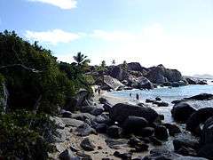 The Baths, Virgin Gorda
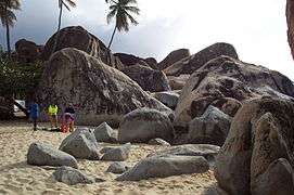 Huge boulders litter the beach at The Baths
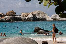 Another view of boulders at The Baths
 Inside The Baths
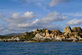 The Baths approaching sunset
 Sunset at Virgin Gorda
 Sunset at Gorda Peak
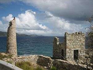 The Copper Mine
References
- ↑ The BVI Beacon "Portrait of a population: 2010 Census published" pg. 4, 20 November 2014
- ↑ BVI Government
- ↑ "Bregado Flax Graduates 21 Students". Island Sun. 2002-07-12. Retrieved 2008-05-27.
- ↑ Stoutt, Jerinice (2006-08-23). "Virgin Gorda Primary School". Development Planning Unit. Archived from the original on 24 July 2007. Retrieved 2008-05-27.
External links
 Media related to Virgin Gorda at Wikimedia Commons
 Virgin Gorda travel guide from Wikivoyage
Coordinates: 18°28′54.8″N 64°23′20.95″W / 18.481889°N 64.3891528°W