Vinegar Hill, Brooklyn
Vinegar Hill[1] is a neighborhood in the borough of Brooklyn in New York City on the East River Waterfront between Dumbo[1] and the Brooklyn Navy Yard.[2] The neighborhood is locally governed by Brooklyn Community Board 2 and is policed by the NYPD's 84th[3] Precinct.
Vinegar Hill gets its name from the Battle of Vinegar Hill, an engagement near Enniscorthy during the Irish Rebellion of 1798.[4] Originally settled by Irish immigrants, this community has maintained its 19th-century look while facing modernization and development from all sides.
Vinegar Hill stretches from the East River Waterfront to Front Street and from the Brooklyn Navy Yard to Bridge Street, roughly comprising a six block area. Before the construction of the Brooklyn-Queens Expressway in the 1950s, Vinegar Hill's area was significantly larger, extending south to Tillary Street, including what is now known as RAMBO. The neighborhood also includes the New York City Housing Authority's Farragut Houses.
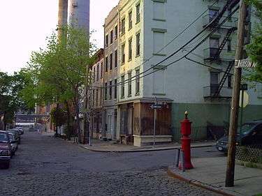
Most of Vinegar Hill consists of 19th century Federal Style and Greek Revival style homes mixed with industrial buildings. The streets on Hudson Avenue, Plymouth, Water and Front are made of Belgian Blocks.

The Vinegar Hill area includes the Vinegar Hill Historic District[5][6][7] and is home to the Con Edison Hudson Avenue Substation.
On the corner of Evans and Little Streets is Quarters A, the Commandant's House, a Federal Style mansion which was once home to Commodore Matthew C. Perry.[8]
History
Before 17th Century
The Canarsee Indians[5][7] were the first inhabitants of both downtown and western Brooklyn. The Canarsee were members of the Algonquian who occupied the Atlantic seaboard from Canada to North Carolina.[9] They were an autonomous band of the Delaware (Leni Lenape) Indians.They established their villages close to the water including the higher ground near the Wallabout Bay that they called Rinnegokonck.[5][7][10] They lived communally in several settlements in western Brooklyn, including one located on the high ground near the present-day Vinegar Hill Historic District, called Rinnegokonc . In the seventeenth century, European explorers arrived on the land and started doing business with Native Americans.
17th Century
In the beginning of the seventeenth century, the primary residents of Vinegar Hill were Canarsee Indians. Dutch settlers began arriving in 1637 along the waterfront area up, up to Fulton Street.[1] When the Dutch settlers arrived in the early seventeenth century, the Canarsee, already weakened by disease, hunger, and warfare, began to sell their land to the settlers and commenced on a long westward migration that would take them as far as Illinois territory.[11] The land was sold by the Indians to Joris Jansen Rapalje. Rapelje acquired the land for farming purposes; it was renamed to Breuckelen circa 1646. The first ferry began operating from the northern point of Fulton street few years earlier in 1642. It connected the land of Breuckelen with Manhattan, the route spanning the East River.
In 1674 the English subjects, under the rule of King Charles II, took control over the land during the events of the Third Anglo-Dutch War. Then, Kings County consisted of six regions: Brooklyn, Bushwick, Flatbush, Flatlands, Gravesend, New Utrecht. The Vinegar Hill district was also part of Brooklyn.[7]

18th Century
Commissioners of Forfeiture took hold of the land from Joris Jansen Rapalje and sold the area of Gold street to Comfort and Joshua Sands in 1784. Sands were planning to develop the land as a summer place for New Yorkers.[12] They built a lot of blocks for a community that was called “Olympia” in 1787.[13] In the late eighteenth century John Jackson bought 100 acres around of the waterfront area near the Wallabout Bay from Remsen estate and built there his own shipyard. He also built houses for the shipyard workers. In 1801 Jackson sold the area around Wallabout Bay to the government for use as a Navy Yard.
The historical reminder of the Sands family and Jackson are still seen on the maps as names of the streets in the Vinegar Hill area.[14]
19th Century
In the late eighteenth century, developers John Jackson and Joshua Sands purchased land in the Vinegar Hill area. Jackson, a noted ship builder, opened a shipyard at the foot of present- day Hudson Avenue and built housing nearby for his workers.[10] In the first years of the nineteenth century, Jackson sold forty acres to the United States government for the Brooklyn Navy Yard, and then built additional housing for Navy Yard personnel.[15] Jackson named the area Vinegar Hill in honor of the last battle of an Irish-English conflict.[10] The Sands family, who had amassed a fortune as merchants and speculators, laid out their land, located west of Jackson's property, into blocks and lots for a community to be called "Olympia” as early as 1787.[10] The brothers expected Olympia to become a summer retreat for New Yorkers because of its hilly topography, plentiful water, and refreshing breezes.[15] However, the Sands's lots that are located within the historic district were not developed residentially until the mid-1830s to the early 1850s when Greek Revival row houses were constructed on the lots.[16] It was not until the early nineteenth century, with the opening of the Navy Yard in 1801, that the area started developing faster.[15] In the late 1830s and early 1840s, the heirs of John Jackson sold off their estate's remaining lots on Hudson Avenue, which were developed individually or in small groups in the 1840s and 1850s with houses that have Greek Revival and Italianate characteristics because of the associations with Athenian democracy.[17] Classic Greek architectural forms were reinterpreted by the architects and builders of the new Republic in their designs for buildings both large and small, whether State Capitol or small row house.[16] Further residential construction occurred on a few remaining vacant lots on Hudson Avenue, Water Street, and Front Street in the years following the Civil War.[15]
Demographics
Many Irish immigrants lived in Vinegar Hill and worked in the Navy Yard in 1798.[4]
References

- 1 2 3 Reiss, Marcia (2001). Fulton Ferry Landing, DUMBO, Vinegar Hill neighborhood history guide. Brooklyn, NY: Brooklyn Historical Society.
- ↑ Bernardo, Leonard & Weiss, Jennifer (2006). Brooklyn by Name. United States of America: New York University Press. p. 37. ISBN 0-8147-9946-9.
- ↑ 84th Precinct, NYPD.
- 1 2 Glueck, Grace & Gardner, Paul (1997). Brooklyn People and Places, Past and Present. New York: Harry N. Abrams, Incorporated. p. 104. ISBN 0-8109-8158-0.
- 1 2 3 http://www.nyc.gov/html/lpc/downloads/pdf/reports/VINEGAR_HILL_HISTORIC_DISTRICT.pdf
- ↑ http://www.nyc.gov/html/lpc/downloads/pdf/maps/vinegar_hill.pdf
- 1 2 3 4 Presa, Donald G. (January 14, 1997). "Vinegar Hill Historic District, Designation Report" (PDF). NYC.gov. New York City Landmarks Preservation Commission.
- ↑ http://focus.nps.gov/pdfhost/docs/NHLS/Text/74001252.pdf
- ↑ Jaffe, Herman J. (1979). The Canarsee Indians: The Original Inhabitants. Brooklyn USA: The Fourth Largest City In America (Brooklyn: Brooklyn College Press). pp. 46–55.
- 1 2 3 4 "HISTORICAL DISTRICTS." Real Property Probate and Trust Journal.Vol. 1, No. 3 (1966): 204-11. HISTORICAL DISTRICTS." Real Property Probate and Trust Journal.Vol. 1, No. 3 (1966): 204-211. Donald G. Presa, 14 Jan. 1997. Web. 23 Apr. 201
- ↑ 1"HISTORICAL DISTRICTS." Real Property Probate and Trust Journal.Vol. 1, No. 3 (1966): 204-11. HISTORICAL DISTRICTS." Real Property Probate and Trust Journal.Vol. 1, No. 3 (1966): 204-211. Donald G. Presa, 14 Jan. 1997. Web. 23 Apr. 201
- ↑ Johnson, Allen (1964). Dictionary of American Biography. New York: Charles Scribner’s Sons. pp. 341–342.
- ↑ The Olympia Settlement in Early Brooklyn. New York. 1929.
- ↑ Who Was Who in America. Chicago: The A.N. Marquis Co. 1963. p. 462.
- 1 2 3 4 2. Revilla, Beatriz Pineda. "Vinegar Hill, the History of 'Irishtown" |THE SIXTH BOROUGH||REDEFINING BROOKLYN'S WATERFRONT|. N.p., n.d. Web. 25 May 2016.
- 1 2 1. "HISTORICAL DISTRICTS." Real Property Probate and Trust Journal.Vol. 1, No. 3 (1966): 204-11. HISTORICAL DISTRICTS." Real Property Probate and Trust Journal.Vol. 1, No. 3 (1966): 204-211. Donald G. Presa, 14 Jan. 1997. Web. 23 Apr. 201
- ↑ 1. "HISTORICAL DISTRICTS." Real Property Probate and Trust Journal.Vol. 1, No. 3 (1966): 204-11. HISTORICAL DISTRICTS." Real Property Probate and Trust Journal.Vol. 1, No. 3 (1966): 204-211. Donald G. Presa, 14 Jan. 1997. Web. 23 Apr. 201 2. Revilla, Beatriz Pineda. "Vinegar Hill, the History of 'Irishtown" |THE SIXTH
Further reading
- Jackson, Kenneth T. & Manbeck, John B. The Neighborhoods of Brooklyn. New York: Citizens for NYC, 2004. Print.
- Snyder-Grenier, Ellen M. Brooklyn! An Illustrated History. Philadelphia: Temple University Press, 1996. Print.
External links
| Wikimedia Commons has media related to Vinegar Hill, Brooklyn. |
Coordinates: 40°42′09″N 73°58′52″W / 40.702553°N 73.981086°W