Villa de Leyva
| Villa de Leyva | |||
|---|---|---|---|
|
Church of Villa de Leyva on the central square | |||
| |||
|
Nickname(s): Villa de Nuestra Señora de Santa Maria de Leyva | |||
 Location of the town of Villa de Leyva and the Leyva municipality in Boyacá Department | |||
| Coordinates: 5°38′N 73°32′W / 5.633°N 73.533°WCoordinates: 5°38′N 73°32′W / 5.633°N 73.533°W | |||
| Department | Boyacá Department | ||
| Province | Ricaurte Province | ||
| Founded | June 12, 1572 | ||
| Founded by | André Diaz Venero de Leyva | ||
| Government | |||
| • Mayor |
Víctor Hugo Forero (2016-2019) | ||
| Area | |||
| • City | 128 km2 (49 sq mi) | ||
| Elevation | 2,149 m (7,051 ft) | ||
| Population (2015) | |||
| • City | 16,478 | ||
| • Density | 130/km2 (330/sq mi) | ||
| • Urban | 9,926 | ||
| Time zone | Colombia Standard Time (UTC-5) | ||
| Website | Official website | ||
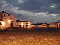


Villa de Leyva, also called Villa de Leiva, is a touristic colonial town and municipality, in the Ricaurte Province, part of the Boyacá department of Colombia. The town is located 37 kilometres (23 mi) west of the departmental capital Tunja. It is "three and a half hours by car or bus from Bogotá."[1]
Located away from major trade routes in a high altitude valley of semi-desert terrain, and with no mineral deposits nearby to exploit, the town has undergone little development in the last 400 years. As a consequence, it is one of the few towns in Colombia to have preserved much of its original colonial style and architecture: the streets and large central plaza are still paved with cobblestones, and many buildings date from the sixteenth century. This has resulted in Villa de Leyva becoming one of Colombia's principal tourist attractions, and it was declared a National Monument on December 17, 1954 to preserve its architecture.[1] The town and the surrounding countryside, which contains several sites of interest, are popular weekend destinations for citizens of Bogota, and attract an increasing number of foreign tourists.
Geography
The urban centre of Villa de Leyva is located in an intermontane valley on the Altiplano Cundiboyacense at 2,149 metres (7,051 ft).[2]
History
The area of Villa de Leyva was inhabited early in the inhabitation of the Altiplano Cundiboyacense. The earliest archaeological evidence has been surfaced around El Infiernito, an archeoastronomical site dating back to pre-Herrera times. The Muisca were the inhabitants of the area at the time of the Spanish conquest and the zaque of Hunza ruled over the area of Villa de Leyva.
The town was founded on June 12, 1572 by and named after the first president of the New Kingdom of Granada, Andrés Díaz Venero de Leiva.[1][2]
Arts and culture
There are several festivals held throughout the year, including a gastronomical festival in November, the water festival, the tree festival, the International Kite-flying Festival in August, the onion beauty pageant in October, and the Festival of Lights on December 7.
Tourism
The focus of the town is the Plaza Mayor, which at 14,000 square meters is the largest square in Colombia and believed to be the largest entirely cobbled square in South America.
The town's most famous son is Antonio Ricaurte (1797–1814), a captain in Simon Bolivar's army fighting for independence, and who died in a famous act of self-sacrifice at San Mateo in what is now Venezuela. The house in which he was born, on the Plazuela de San Agustín, was acquired by Colombia's Air Force in 1977 and turned into a military museum.
Villa de Leyva has also been home to two other well-known figures in Colombian history. Antonio Nariño, best known for translating The Rights of Man into Spanish and a leading advocate for Colombian independence, lived the last few years of his life and died in Villa de Leyva. Luis Alberto Acuña (1904 – 1993), one of the most important Colombian artists of the 20th century, also spent his final years in the town. The houses of both men are now museums containing their personal properties, and in the case of Acuña, a selection of his works, including two murals on the walls of the internal patio.
The House of the First Congress, where the First Congress of the United Provinces of Nueva Granada met on October 4, 1812, is located on the north corner of the main plaza. It is currently the site of the municipal council.
A few miles further west is a Muisca astronomy observatory, made of phallic stones, colloquially named El Infiernito ("little hell" in Spanish), as the Spanish conquistadors were horrified by the stones and proclaimed that the Muisca would be banished to hell for their obscene representations.
To the north-east of Villa de Leyva, the land rises to cloud-forest and includes the national park of Iguaque, and a group of seven waterfalls collectively named La Periquera, 15 kilometres (9.3 mi) from the town centre.
Paleontology
Near Villa de Leyva are several other sites of interest. The valley in which the town is located is rich in fossils from the Paja Formation (Cretaceous era), the most famous being a near-complete Kronosaurus boyacensis discovered in 1977 about 3 miles (4.8 km) west of Villa de Leyva. Known simply as El Fósil, the fossil was left in situ where it was discovered and a museum was built around it: another smaller Kronosaurus fossil was discovered nearby and brought to the museum to be displayed alongside the larger specimen.[1] In the same formation the fossil ichthyosaurs Platypterygius sachicarum and Muiscasaurus catheti and the brachiosaur Padillasaurus leivaensis and pliosaur Brachauchenius, later reclassified as Stenorhynchosaurus, have been discovered.[3][4][5][6]
Gallery

 Statue of Andrés Diaz Venero de Leyva
 Statue of Antonio Nariño
 Church interior
 Statue of Jesus Christ in Villa de Leyva
 Ammonite monument in Villa de Leyva
 Paleontological museum with El Fósil
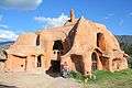 Clay house
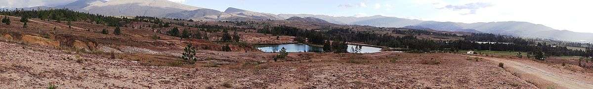
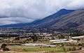 Rural area
 Pozos Azules
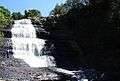 La Periquera waterfall
In popular culture
- Florentino Ariza, the main character of Gabriel Garcia Marquez's novel Love in the Time of Cholera, spends part of his life in Villa de Leyva
- Part of the film Cobra Verde by Werner Herzog was filmed here
- A Spanish-language soap opera version of the Zorro story has been filmed here
See also
References
- 1 2 3 4 David Carr (October 22, 2009). "Villa de Leyva, a Graceful Window on Colonial Colombia". NY Times. Retrieved June 18, 2014.
- 1 2 (Spanish) Official website Villa de Leyva
- ↑ Platypterygius sachicarum in the Paleobiology Database
- ↑ Muiscasaurus catheti in the Paleobiology Database
- ↑ Padillasaurus leivaensis in the Paleobiology Database
- ↑ Brachauchenius in the Paleobiology Database
External links
| Wikimedia Commons has media related to Villa de Leyva. |
| Wikivoyage has a travel guide for Villa de Leyva. |
- (Spanish) Tourism guide
- (Spanish) Colombia Official Travel Guide
Treasures of Colombia | |||||||||||||||||||||||||||||||||||||||||||||||||||||
|---|---|---|---|---|---|---|---|---|---|---|---|---|---|---|---|---|---|---|---|---|---|---|---|---|---|---|---|---|---|---|---|---|---|---|---|---|---|---|---|---|---|---|---|---|---|---|---|---|---|---|---|---|---|
Archaeological sites · Colombia magia salvaje · National monuments · National parks · World Heritage sites | |||||||||||||||||||||||||||||||||||||||||||||||||||||
| |||||||||||||||||||||||||||||||||||||||||||||||||||||
| |||||||||||||||||||||||||||||||||||||||||||||||||||||
| |||||||||||||||||||||||||||||||||||||||||||||||||||||
Source: Wills, Fernando et al. 2001. Nuestro patrimonio - 100 tesoros de Colombia - Our heritage - 100 treasures of Colombia, 1-311. El Tiempo. | |||||||||||||||||||||||||||||||||||||||||||||||||||||