Victory, Saratoga County, New York
- Another Victory is a town in Cayuga County, New York.
| Victory | |
|---|---|
| Village | |
|
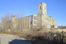
The Victory Mills | |
| Motto: Home of the Saratoga Battle Monument | |
 Victory Location within the state of New York | |
| Coordinates: 43°5′19″N 73°35′37″W / 43.08861°N 73.59361°WCoordinates: 43°5′19″N 73°35′37″W / 43.08861°N 73.59361°W | |
| Country | United States |
| State | New York |
| County | Saratoga |
| Town | Saratoga |
| Incorporated | 1849 |
| Government | |
| • Mayor | James M. Sullivan (G) |
| Area | |
| • Total | 0.5 sq mi (1.4 km2) |
| • Land | 0.5 sq mi (1.4 km2) |
| • Water | 0.0 sq mi (0.0 km2) |
| Population (2000) | |
| • Total | 544 |
| • Density | 1,030.7/sq mi (398.0/km2) |
| Time zone | Eastern (EST) (UTC-5) |
| • Summer (DST) | EDT (UTC-4) |
| Area code(s) | 518 |
| FIPS code | 36-77431 |
| Website | www.villageofvictory.org |
Victory is a village in Saratoga County, New York, United States. The population was 544 at the 2000 census. The village is located in the northeast part of the town of Saratoga, southwest of and bordering the village of Schuylerville. Victory is one of the smallest villages in New York.
History
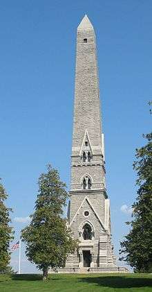
The village was incorporated in 1849. The name Victory is most certainly due to the defeat of the British at the Battles of Saratoga, where Burgoyne surrendered his sword to Gates.
The village has also been called "Victory Mills" due to the large (now defunct) cotton mill of the Saratoga Victory Manufacturing Company. The company operated there from 1846 to 1929 and was centrally located on the primary road through town, Gates Avenue. The US Postal Service refers to the village's ZIP code as Victory Mills.
The Victory Mills building was listed on the National Register of Historic Places on January 19, 2010.[1]
Geography
Victory is located at 43°5′19″N 73°35′37″W / 43.08861°N 73.59361°W (43.088514, -73.593563).[2]
According to the United States Census Bureau, the village has a total area of 0.5 square miles (1.4 km²), all of it land.
The village is located on the north bank of Fish Creek, a tributary of the nearby Hudson River.
New York State Route 32, Gates Avenue, passes through the village.
Demographics
| Historical population | |||
|---|---|---|---|
| Census | Pop. | %± | |
| 1860 | 636 | — | |
| 1870 | 870 | 36.8% | |
| 1880 | 1,120 | 28.7% | |
| 1890 | 822 | −26.6% | |
| 1900 | 795 | −3.3% | |
| 1910 | 748 | −5.9% | |
| 1920 | 725 | −3.1% | |
| 1930 | 473 | −34.8% | |
| 1940 | 520 | 9.9% | |
| 1950 | 488 | −6.2% | |
| 1960 | 497 | 1.8% | |
| 1970 | 718 | 44.5% | |
| 1980 | 571 | −20.5% | |
| 1990 | 581 | 1.8% | |
| 2000 | 544 | −6.4% | |
| 2010 | 605 | 11.2% | |
| Est. 2015 | 589 | [3] | −2.6% |
As of the census[5] of 2000, there were 544 people, 189 households, and 144 families residing in the village. The population density was 1,030.7 people per square mile (396.3/km²). There were 216 housing units at an average density of 409.2 per square mile (157.4/km²). The racial makeup of the village was 97.61% White, 0.55% African American, 0.37% Native American, and 1.47% from two or more races. Hispanic or Latino of any race were 1.29% of the population.
There were 189 households out of which 46.6% had children under the age of 18 living with them, 54.5% were married couples living together, 13.8% had a female householder with no husband present, and 23.8% were non-families. 18.5% of all households were made up of individuals and 10.1% had someone living alone who was 65 years of age or older. The average household size was 2.88 and the average family size was 3.19.
In the village the population was spread out with 30.1% under the age of 18, 7.5% from 18 to 24, 32.2% from 25 to 44, 17.3% from 45 to 64, and 12.9% who were 65 years of age or older. The median age was 35 years. For every 100 females there were 95.7 males. For every 100 females age 18 and over, there were 103.2 males.
The median income for a household in the village was $41,250, and the median income for a family was $37,292. Males had a median income of $29,219 versus $22,656 for females. The per capita income for the village was $17,484. About 10.7% of families and 9.1% of the population were below the poverty line, including 10.8% of those under age 18 and 2.4% of those age 65 or over.
References
- ↑ "National Register of Historic Places". WEEKLY LIST OF ACTIONS TAKEN ON PROPERTIES: 1/19/10 THROUGH 1/22/10. National Park Service. 2010-01-29.
- ↑ "US Gazetteer files: 2010, 2000, and 1990". United States Census Bureau. 2011-02-12. Retrieved 2011-04-23.
- ↑ "Annual Estimates of the Resident Population for Incorporated Places: April 1, 2010 to July 1, 2015". Retrieved July 2, 2016.
- ↑ "Census of Population and Housing". Census.gov. Retrieved June 4, 2015.
- ↑ "American FactFinder". United States Census Bureau. Retrieved 2008-01-31.
External links
- Village of Victory Official Website-http://www.villageofvictory.org
- Village of Victory information
Municipalities and communities of Saratoga County, New York, United States | ||
|---|---|---|
| Cities | 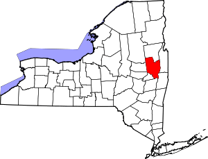 | |
| Towns | ||
| Villages | ||
| CDPs | ||
| Other hamlets | ||
| Footnotes | ‡This populated place also has portions in an adjacent county or counties | |