Victoria Bridge, Brisbane
| Victoria Bridge | |
|---|---|
 Victoria Bridge | |
| Coordinates | 27°28′21″S 153°01′16″E / 27.472476°S 153.021022°ECoordinates: 27°28′21″S 153°01′16″E / 27.472476°S 153.021022°E |
| Carries | Motor vehicles, pedestrians and cyclists |
| Crosses | Brisbane River |
| Locale | Brisbane, Queensland, Australia |
| Characteristics | |
| Material | Concrete |
| Total length | 313 m |
| Number of spans | 3 |
| History | |
| Designer | Coordinator General's Department |
| Construction end | 1969 |
| Opened | 1969 |
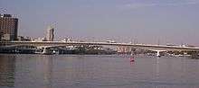
The Victoria Bridge is a vehicular and pedestrian bridge over the Brisbane River. The current bridge, opened in 1969, is the third permanent crossing erected at this location. It is shared by vehicular traffic, pedestrians and cyclists.
Victoria Bridge connects South Brisbane near the South Bank Parklands and Queensland Cultural Centre to the Brisbane central business district (CBD) at North Quay.
Half of the road space on the bridge is now given over to the South-East Busway.[1] In the 2006 Brisbane City Centre Draft Masterplan, a new crossing immediately adjacent to the Victoria Bridge, tentatively named the Adelaide Street Bridge was recommended for a feasibility study.[2]
Former bridges at this site


Construction of a bridge across the Brisbane River was first agreed to in 1861. The newly formed Legislative Assembly of Queensland forced the council to pay for the costs. £70,000 worth of borrowings was acquired from the Bank of Queensland.[3] Work first began on the foundations for the first bridge across the Brisbane River on 22 August 1864.[4] The bridge, known as the Brisbane Bridge, was a tolled, timber structure which opened in June 1865.[4] It was a temporary structure which was to be replaced by a more elaborately designed, iron lattice-girder bridge.[3] The Bank of Queensland failed in July 1866, bringing about a halt to funding for the project. The state government was reluctant to take on responsibility for the bridge's construction because it didn't want to incur debt. The timber bridge quickly succumbed to marine wood worm and began to progressively collapse.[5][6] The council wasn't able to fully repair the structure and its remnants took two years to fall away into the river.[4]
In 1871, an English company, Peto, Brassey and Co, agreed to complete the bridge.[3] A new crossing, opened on 15 June 1874[7] by the Governor of Queensland, the George Phipps, 2nd Marquess of Normanby, was an iron structure and a toll bridge.[5] The bridge was paid for by significant council borrowings that were to be recouped by tolls.[8] However a lack of revenue forced its transfer to the Colonial Government.[8] The tolls were abolished at this time.[3] It included a turning span to allow tall masted river traffic to pass upstream.[4] The position of the swinging span was fixed when the tram-lines were laid along the bridge.[9] It carried a 6 in (0.15 m) and a 9 in (0.23 m) diameter pipe which supplied mains water to South Brisbane.[10] This bridge was partially washed away in the 1893 Brisbane flood.[5][11]
Another replacement bridge was built[12] and entered service in 1897, lasting until 1969, when it was demolished.[5] In the meantime, ferries were used to transport people and goods. This second bridge was designed by Alfred Barton Brady. It was constructed of steel and had two carriage ways and two footpaths.[9] As early as 1943 evidence of the bridge buckling from the weight of increased traffic was noticed. Tram numbers on the bridge had to be restricted and the footpath removed as a result.[13]
A new bridge which was opened on 14 April 1969,[4] was needed to meet growing traffic demands.[11] It cost A$3.2 million and featured a modern design which has been described as sleek and elegant.[9] For a short period both bridges were open, each operating in one direction only.[9]
A portion of the southern abutment of the previous bridge remains adjacent to the new bridge, carrying a pedestrian arch, a short remnant of tram track and a memorial to Hector Vasyli, a young boy who was killed in a traffic accident at that point when waving to servicemen returning from the First World War. The abutment is heritage-listed.
See also
References
- ↑ Heywood, Lachlan (2000-12-14). "Bridge changes slammed". The Courier-Mail (6 – Late City ed.). p. 009. Retrieved 2014-08-01.
- ↑ Tony Moore (2011-11-22). "Car ban a bridge too far". Brisbane Times. Retrieved 2014-08-01.
- 1 2 3 4 Laverty, John (2009). The Making of a Metropolis: Brisbane 1823—1925. Salisbury, Queensland: Boolarong Press. pp. 156–157. ISBN 978-0-9751793-5-2.
- 1 2 3 4 5 Brisbane 150 Stories. Brisbane City Council Publication. 2009. pp. 36–37. ISBN 978-1-876091-60-6.
- 1 2 3 4 Hadwen, Ian; Janet Hogan; Carolyn Nolan (2005). Brisbane's historic North Bank 1825–2005. Brisbane: Royal Historial Society of Queensland. pp. 62–65. ISBN 0-9757615-0-1.
- ↑ Longhurst, Robert; William Douglas. The Brisbane River: A pictorial history. Brisbane: W.D. Incorporated Pty Ltd. p. 23. ISBN 0-646-34472-2.
- ↑ "The Opening of the Bridge.". The Brisbane Courier. National Library of Australia. 16 June 1874. p. 3. Retrieved 7 October 2012.
- 1 2 Cole, John R. (1984). Shaping a city. Albion, Queensland: William Brooks Queensland. p. 19. ISBN 0-85568-619-7.
- 1 2 3 4 Hogan, Janet (1982). Living History of Brisbane. Spring Hill, Queensland: Boolarong Publications. pp. 45, 77, 124. ISBN 0-908175-41-8.
- ↑ Oliver, Bill (2008). Carolyn Fitz-Gerald, ed. "Floods, water quality and river crossings, Mount Crosby 1890–1931". Brisbane:Water, Power and Industry Paper No. 20. Kelvin Grove, Queensland: Brisbane History Group: 31. ISBN 978-0-9751793-3-8.
- 1 2 Gregory, Helen (2007). Brisbane Then and Now. Wingfield, South Australia: Salamander Books. pp. 8–9. ISBN 978-1-74173-011-1.
- ↑ "You Don't Say So!" (Vol 1, Issue 21). Fair Play. National Library of New Zealand. 1 May 1894. p. 10.
- ↑ Cole, John R. (1984). Shaping a city. Albion, Queensland: William Brooks Queensland. p. 162. ISBN 0-85568-619-7.
External links
| Wikimedia Commons has media related to Victoria Bridge, Brisbane. |
- Destruction of the Victoria Bridge: 1893 Brisbane Flood – John Oxley Library Blog
- Brisbane City Centre Draft Masterplan
- Victoria Bridge at Structurae