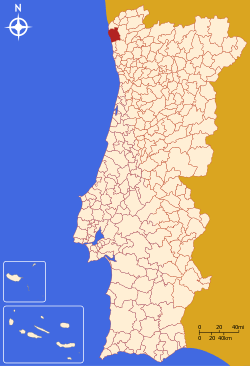
Viana do Castelo
| Viana do Castelo | |||
|---|---|---|---|
| Municipality | |||
|
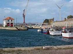
The port of Viana do Castelo | |||
| |||
 | |||
| Coordinates: 41°42′N 8°50′W / 41.700°N 8.833°WCoordinates: 41°42′N 8°50′W / 41.700°N 8.833°W | |||
| Country |
| ||
| Region | Norte | ||
| Subregion | Minho-Lima | ||
| Intermunic. comm. | Alto Minho | ||
| District | Viana do Castelo | ||
| Government | |||
| • President | José Maria Costa (PS) | ||
| Area | |||
| • Total | 319.02 km2 (123.17 sq mi) | ||
| Elevation | 12 m (39 ft) | ||
| Highest elevation | 825 m (2,707 ft) | ||
| Lowest elevation | 0 m (0 ft) | ||
| Population (2011) | |||
| • Total | 88,725 | ||
| • Density | 280/km2 (720/sq mi) | ||
| Time zone | WET/WEST (UTC+0/+1) | ||
| Postal code | 4904 | ||
| Area code | 258 | ||
| Patron | Nossa Senhora da Agonia | ||
| Website | http://www.cm-viana-castelo.pt | ||
Viana do Castelo (Portuguese pronunciation: [viˈɐnɐ ðu kɐʃˈtɛlu]) is a municipality and seat of the district of Viana do Castelo in the Norte Region of Portugal. The population in 2011 was 88,725,[1] in an area of 319.02 km².[2] The urbanized area of the municipality, comprising the city, has a population of approximately 36,148 inhabitants.
History
Human settlement in the region of Viana began during the Mesolithic era, from discoveries and archaeological excavations. Even around the Roman occupation the area was settled along the Mount of Santa Luzia.
The settlement of Viana da Foz do Lima, which it was called when King Afonso III of Portugal issued a foral (charter) on 18 July 1258, was a formalization of the 1253 Viana that the area was named.
In the 16th century, its port gained great importance as one of the entry-points for Portuguese explorers and traders, involved in the Portuguese discoveries. Many of the historical buildings originated during this period.
The prosperity that continued developed from the town's role as a port, protected by defensive structures (such as the Tower of Roqueta) to repel pirates from Galicia and north Africa. The port's ties to northern Europe came primarily from exports of wine, fruits and salt, and imports of tile, textiles and glass.
After the maritime discoveries and trade, the commercial life of Viana reached its greatest proportions during the reign of Queen Maria II of Portugal, when the monarch established the Associação Comercial de Viana do Castelo in 1852 (the fourth oldest public company of its type). The queen, in order to reward the loyalty of its citizens, who did not surrender to the Count of Antas, elevated the town to the status of city on 20 January 1848, renaming the settlement with its current name.
During the dictatorial regime, Viana do Castelo was one of the most important ports of the Portuguese cod fisheries.[3]
Geography
|
|
Administratively, the municipality is divided into 27 civil parishes (freguesias):[4]
- Afife
- Alvarães
- Amonde
- Anha
- Areosa
- Barroselas e Carvoeiro
- Cardielos e Serreleis
- Carreço
- Castelo do Neiva
- Chafé
- Darque
- Freixieiro de Soutelo
- Geraz do Lima (Santa Maria, Santa Leocádia e Moreira) e Deão
- Lanheses
- Mazarefes e Vila Fria
- Montaria
- Mujães
- Nogueira, Meixedo e Vilar de Murteda
- Outeiro
- Perre
- Santa Marta de Portuzelo
- São Romão de Neiva
- Subportela, Deocriste e Portela Susã
- Torre e Vila Mou
- Viana do Castelo (Santa Maria Maior e Monserrate) e Meadela
- Vila de Punhe
- Vila Franca
Climate
| Climate data for Viana do Castelo | |||||||||||||
|---|---|---|---|---|---|---|---|---|---|---|---|---|---|
| Month | Jan | Feb | Mar | Apr | May | Jun | Jul | Aug | Sep | Oct | Nov | Dec | Year |
| Record high °C (°F) | 24.0 (75.2) |
25.0 (77) |
30.5 (86.9) |
31.6 (88.9) |
35.6 (96.1) |
38.6 (101.5) |
38.0 (100.4) |
39.5 (103.1) |
36.4 (97.5) |
32.6 (90.7) |
26.2 (79.2) |
24.6 (76.3) |
39.5 (103.1) |
| Average high °C (°F) | 14.6 (58.3) |
15.5 (59.9) |
17.9 (64.2) |
18.5 (65.3) |
20.7 (69.3) |
24.5 (76.1) |
26.3 (79.3) |
26.4 (79.5) |
24.8 (76.6) |
20.9 (69.6) |
17.4 (63.3) |
15.2 (59.4) |
20.23 (68.4) |
| Daily mean °C (°F) | 9.8 (49.6) |
10.5 (50.9) |
12.7 (54.9) |
13.7 (56.7) |
15.9 (60.6) |
19.2 (66.6) |
20.8 (69.4) |
20.8 (69.4) |
19.2 (66.6) |
16.1 (61) |
12.8 (55) |
10.8 (51.4) |
15.19 (59.34) |
| Average low °C (°F) | 4.9 (40.8) |
5.5 (41.9) |
7.4 (45.3) |
8.8 (47.8) |
11.1 (52) |
13.9 (57) |
15.3 (59.5) |
15.1 (59.2) |
13.7 (56.7) |
11.2 (52.2) |
8.1 (46.6) |
6.4 (43.5) |
10.12 (50.21) |
| Record low °C (°F) | −3.9 (25) |
−2.8 (27) |
−3.7 (25.3) |
−0.4 (31.3) |
0.8 (33.4) |
5.5 (41.9) |
9.0 (48.2) |
8.0 (46.4) |
7.0 (44.6) |
2.4 (36.3) |
−1.2 (29.8) |
−5.1 (22.8) |
−5.1 (22.8) |
| Source: [5] | |||||||||||||
Economy
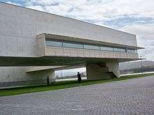
The city has a seaport with naval repairing facilities; its major industries are related to naval construction and repair, with the Estaleiros da Viana do Castelo remaining one of the few large shipyards still in operation.
Architecture
Civic
- Geraz do Lima carriage museum
- Renaissance fountain (1535) in the Major Square
- Palacio de Tavoras, a noble residence from the 16th and 17th centuries
- Municipal Museum, housed in an 18th-century building and home to
- Paços do Conselho ("Palace of the Council", 1502), of which only the façade remains today
Military
- Castelo do Neiva: the castle has been owned by the parish of Viana do Castelo since the beginning of the 19th century.
- Church of Sâo Domingos (1576)
- Church of Santa Luzia (19th century), designed by Miguel Ventura Terra
- Nossa Senhora da Agonia, church in Roccoco style
Religious
- Chapel of the Sagrada Família (Portuguese: Capela da Sagrada Família e Portal da Quinta dos Espregueira)
- Chapel of Nossa Senhora da Esperança (Portuguese: Capela de Nossa Senhora da Esperança)
- Sé Cathedral of Viana do Castelo (Portuguese: Igreja Matriz de Viana do Castelo/Catedral de Viana do Castelo/Sé de Viana do Castelo), the 15th-century parochial church and cathedral, was constructed in the Romanesque style, comprising a façade flanked by two large towers with merlons, while the middle Gothic portal with archivolts is decorated by sculptures depicting the Passion of Christ and of the Apostles. The interior designed in the form of the Latin cross, includes a nave and two aisles (separated by arches supported by pillars), as well as two ancillary chapels dedicated to São Bernado and the Holy Sacrament, both attributed to João Lopes "the Elder".
- Misericórdia of Viana do Castelo (Portuguese: Misericórdia de Viana do Castelo), designed in the Flemish-style, the building dates back to 1589.
Culture

In 2010, Viana do Castelo started to implement a project of rehabilitation of the city called Viana Criativa [6] which is based on an investigation made by Paulo Caldeira among 4 years. Such project has the main purpose to attract more residents to a city where, during the last 500 years, many people around the world arrived to trade. Once upon a time, Viana was the second center of commerce of Portugal and some investigators are now recognising that fado music was born based on the typical songs of Minho region.
International relations
Viana do Castelo is twinned with:
 Portugal Cove-St. Philip's, Canada
 Aveiro, Portugal
 Riom, France[7]
Gallery
.jpg) Viana do Castelo, Portugal
Viana do Castelo, Portugal Viana do Castelo, Portugal
.jpg) Viana do Castelo, Portugal
Viana do Castelo, Portugal.jpg) Viana do Castelo, Portugal
Viana do Castelo, Portugal.jpg) Viana do Castelo, Portugal
Viana do Castelo, Portugal.jpg) Viana do Castelo, Portugal
Viana do Castelo, Portugal.jpg) Viana do Castelo, Portugal
Viana do Castelo, Portugal.jpg) Viana do Castelo, Portugal
Viana do Castelo, Portugal.jpg) Viana do Castelo, Portugal
Viana do Castelo, Portugal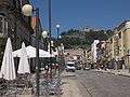 Viana do Castelo, Portugal
.jpg) Viana do Castelo, Portugal
Viana do Castelo, Portugal.jpg) Viana do Castelo, Portugal
Viana do Castelo, Portugal
References
- ↑ Instituto Nacional de Estatística
- ↑ Direção-Geral do Território
- ↑ SILVA, A. J. M. (2015), The fable of the cod and the promised sea. About portuguese traditions of bacalhau, in BARATA, F. T- and ROCHA, J. M. (eds.), Heritages and Memories from the Sea, Proceedings of the 1st International Conference of the UNESCO Chair in Intangible Heritage and Traditional Know-How: Linking Heritage, 14–16 January 2015. University of Evora, Évora, pp. 130-143. PDF version
- ↑ Diário da República. "Law nr. 11-A/2013, pages 552 127-128" (pdf) (in Portuguese). Retrieved 4 August 2014.
- ↑ "Climate Normals - Viana do Castelo 1981-2010". Portuguese Institute of Meteorology. Retrieved 11 February 2016.
- ↑ A PROJECT TO CHANGE A CITY
- ↑ "National Commission for Decentralised cooperation". Délégation pour l’Action Extérieure des Collectivités Territoriales (Ministère des Affaires étrangères) (in French). Retrieved 2013-12-26.
External links
-
 Viana do Castelo travel guide from Wikivoyage
 - Viana do Castelo - A Healthy City - Youtube video
- Photos from Viana do Castelo
- O blog de Viana do Castelo