Vermont Route 235
| ||||
|---|---|---|---|---|
|
Map of Franklin County in northwestern Vermont with VT 235 highlighted in red | ||||
| Route information | ||||
| Maintained by the Town of Franklin | ||||
| Length: | 4.64 mi[1] (7.47 km) | |||
| Major junctions | ||||
| South end: |
| |||
| North end: |
| |||
| Location | ||||
| Counties: | Franklin | |||
| Highway system | ||||
| ||||

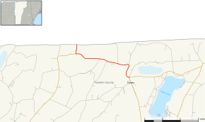
Vermont Route 235 is a short state highway in Franklin County, Vermont, United States. It runs from Vermont Route 120 in Franklin northwest to the Morses Line Border Crossing near the village of Morses Line, where it crosses into Quebec, Canada, and connects to Quebec Route 235, from which it derives its number. The entire route is town-maintained and internally designated as major collector 299.
Route description
VT 235 begins in the south at VT 120 in the town of Franklin. It runs north and west for just over 3 miles (4.8 km), into the small village of Morses Line situated about 0.5 miles (0.80 km) south of the Canada–United States border. Here, VT 235 meets the northern terminus of VT 207 and then turns directly north and crosses the border into Quebec, where it meets Quebec Route 235 in Saint-Armand.
Major intersections
The entire route is in Franklin, Franklin County. [1]
| mi[1] | km | Destinations | Notes | ||
|---|---|---|---|---|---|
| 0.00 | 0.00 | ||||
| 4.08 | 6.57 | Village of Morses Line; northern terminus of VT 207 | |||
| 4.64 | 7.47 | Continuation into Quebec, Morses Line Border Crossing | |||
| 1.000 mi = 1.609 km; 1.000 km = 0.621 mi | |||||
References
- 1 2 3 Division of Policy, Planning and Intermodal Development (October 2, 2014). "Vermont General Highway Map, Town of Franklin, Franklin County" (PDF). Vermont Agency of Transportation. Retrieved April 25, 2015.