Vermont Route 139
| ||||
|---|---|---|---|---|
|
Map of Franklin County in northwestern Vermont with VT 139 highlighted in red | ||||
| Route information | ||||
| Length: | 1.822 mi[1] (2.932 km) | |||
| Major junctions | ||||
| South end: |
| |||
| North end: |
| |||
| Location | ||||
| Counties: | Franklin | |||
| Highway system | ||||
| ||||

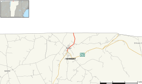
Vermont Route 139 (VT 139) is a 1.822-mile-long (2.932 km) north–south state highway running entirely within the town of Richford, Franklin County, in northern Vermont. The southern terminus of the route is at the intersection with Vermont Route 105. Its northern terminus is at the Canada–US border, continuing as Quebec Route 139 in the village of Abercorn, Quebec.
Major intersections
The entire route is in Richford, Franklin County. [1]
| mi[1] | km | Destinations | Notes | ||
|---|---|---|---|---|---|
| 0.000 | 0.000 | ||||
| 1.822 | 2.932 | Continuation into Quebec | |||
| 1.000 mi = 1.609 km; 1.000 km = 0.621 mi | |||||
References
- 1 2 3 Traffic Research Unit (May 2012). "2011 (Route Log) AADTs for Major Collectors" (PDF). Policy, Planning and Intermodal Development Division, Vermont Agency of Transportation. Retrieved April 22, 2015.
External links
This article is issued from Wikipedia - version of the 8/16/2016. The text is available under the Creative Commons Attribution/Share Alike but additional terms may apply for the media files.