Veraval
| Veraval वेरावल વેરાવળ | |
|---|---|
| city | |
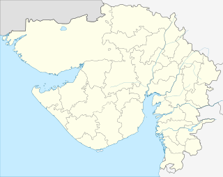 Veraval  Veraval Location in Gujarat, India | |
| Coordinates: 20°55′N 70°22′E / 20.91°N 70.37°ECoordinates: 20°55′N 70°22′E / 20.91°N 70.37°E | |
| Country |
|
| State | Gujarat |
| District | Gir Somnath district |
| Elevation | 0 m (0 ft) |
| Population (2011)[1] | |
| • Total | 153,696 |
| Languages | |
| • Official | Gujarati |
| Time zone | IST (UTC+5:30) |
Veraval is a municipality and the headquarters of Gir Somnath district in the Indian state of Gujarat. It is 6 km from Somnath.
History

Veraval was founded in 13th or 14th century by Rao Veravalji Vadher, a Rajput. Veraval was once a fortified port town of the royal family of Junagadh. It was a part of the Kingdom of Junagadh till 1947 when Junagadh was merged with India. The city still bears some remnants of the old Nawabi heritage, the beautiful Nawabi summer palace being among them. There are ruins of the old Nawabi fort and Nawabi Gates in and around the place. The old walls of the port are now ruined, but the impressive Junagadh gate and the Patan gate are still seen, but are in a very bad state.
The Nawabi Palace with gothic features which is one of the main attractions. It is popularly known as Somnath College (the palace was converted into a college after it was abandoned by the Nawab). At present it is the building of a Sanskrit university. The town is often known as the gateway to the magnificent temple of Somnath and the pilgrimage centres of Prabhas Patan and Bhalkha. Veraval is also the nearest town to the Gir National Park (42 km away).
Before the rise of Surat, Veraval was the major seaport for pilgrims to Mecca. Its importance now is as a fishing port, one of the largest in India. Sea going dhows and wooden fishing boats are still being built by the Fishermen's without the use of any Hightech Machines. Traditional skills are passed down from father to son. About 25 km from the veraval a historical place is located at Savani village.
Geography

Veraval is located at 20°54′N 70°22′E / 20.9°N 70.37°E.[2] It has an average elevation of 0 metres (0 feet).
Demographics
As of the 2001 India census,[3] Veraval had a population of 141,250. Males constitute 51% of the population and females 49%. Veraval has an average literacy rate of 62%, higher than the national average of 59.5%: male literacy is 71%, and female literacy is 53%. In Veraval, 14% of the population is under 6 years of age.
Climate
Veraval has a hot semi-arid climate (Köppen climate classification BSh) with warm to hot temperatures throughout the year. Almost all precipitation falls during the summer monsoon season from June to September.
| Climate data for Veraval | |||||||||||||
|---|---|---|---|---|---|---|---|---|---|---|---|---|---|
| Month | Jan | Feb | Mar | Apr | May | Jun | Jul | Aug | Sep | Oct | Nov | Dec | Year |
| Record high °C (°F) | 34.2 (93.6) |
36.7 (98.1) |
40.4 (104.7) |
41.5 (106.7) |
40.7 (105.3) |
34.1 (93.4) |
36.9 (98.4) |
33.8 (92.8) |
38.0 (100.4) |
41.0 (105.8) |
38.7 (101.7) |
34.8 (94.6) |
41.5 (106.7) |
| Average high °C (°F) | 28.7 (83.7) |
29.4 (84.9) |
31.3 (88.3) |
31.8 (89.2) |
32.0 (89.6) |
32.0 (89.6) |
30.5 (86.9) |
29.5 (85.1) |
30.8 (87.4) |
33.5 (92.3) |
33.0 (91.4) |
30.4 (86.7) |
31.08 (87.93) |
| Daily mean °C (°F) | 21.5 (70.7) |
22.3 (72.1) |
24.9 (76.8) |
27.0 (80.6) |
28.6 (83.5) |
29.5 (85.1) |
28.4 (83.1) |
27.4 (81.3) |
27.6 (81.7) |
27.9 (82.2) |
26.2 (79.2) |
23.2 (73.8) |
26.21 (79.18) |
| Average low °C (°F) | 14.2 (57.6) |
15.2 (59.4) |
18.4 (65.1) |
22.1 (71.8) |
25.2 (77.4) |
26.9 (80.4) |
26.2 (79.2) |
25.2 (77.4) |
24.3 (75.7) |
22.3 (72.1) |
19.3 (66.7) |
16.0 (60.8) |
21.28 (70.3) |
| Record low °C (°F) | 7.2 (45) |
7.1 (44.8) |
10.8 (51.4) |
14.8 (58.6) |
17.9 (64.2) |
20.7 (69.3) |
21.1 (70) |
20.5 (68.9) |
19.7 (67.5) |
16.0 (60.8) |
11.9 (53.4) |
8.1 (46.6) |
7.1 (44.8) |
| Average precipitation mm (inches) | 1 (0.04) |
1 (0.04) |
0 (0) |
1 (0.04) |
1 (0.04) |
207 (8.15) |
229 (9.02) |
168 (6.61) |
79 (3.11) |
15 (0.59) |
33 (1.3) |
0 (0) |
735 (28.94) |
| Average rainy days | 0.1 | 0.2 | 0.1 | 0.1 | 0.2 | 6.6 | 13.4 | 13.2 | 6.0 | 1.1 | 1.0 | 0.1 | 42.1 |
| Average relative humidity (%) | 58 | 66 | 71 | 79 | 82 | 84 | 87 | 87 | 85 | 75 | 62 | 59 | 74.6 |
| Source: NOAA (1971-1990)[4] | |||||||||||||
People
Veraval has a predominant Gujarati population. Amongst Gujaratis, Jains (Oswal), the sonis (Jewellers,mainly from the clans of Dhakan, Patt, Sagar, etc.), the Kharwa, Ahir brahma smaj and the Kolis Turks, Rajwadi bhois, Hadi, Lohanas, Maleks, Memons, Patnis and Raykas. There is also a sizable population Sindhis. Gujarati and Hindi are the most common languages in the town.
Industry

Fisheries have always been the main industries in the town and are dominated by the Kharwas (fisherfolk). The fishing is done mostly on traditional boats and trawlers. Veraval also has a large boat making industry. Veraval is home to a large number of fish processing factories in G.I.D.C which export prime quality seafood to USA, Japan, SE Asian, Gulf and EU Countries. The seafood-industry which was started through government initiative now is in its prime and many importers are attracted towards Veraval from around the globe. Regional research centers of CIFT and CMFRI situated at Veraval have done Yeoman service in development of fisheries sector in Gujarat.
Veraval also is home to Aditya Birla Nuvo Ltd (Formerly:Indian-Rayon Industries Ltd) which is one of India's largest rayon manufacturing companies.
There are various chemical, thread and cement companies around Veraval which provide employment to the local youth. The major ones being Indian Rayon NUVO Ltd., Gujarat Ambuja Cement Ltd, Gujarat Siddhee Cement Ltd and Gujarat Heavy Chemicals Ltd.
Transport

Veraval Junction is a fairly busy railway junction station for Western Railways and is served by more than 14 pairs of regional and long-distance trains.
Daily (or multiple daily) trains connect it to major cities in Gujarat such as Ahmedabad, Bharuch, Jamnagar, Junagadh, Porbandar, Rajkot, Surat and Vadodara.
Daily connections are also available to many other towns in Gujarat such as Keshod, Jetalsar, Gondal, Wankaner, Surendranagar, Viramgam, Nadiad, Anand, Valsad, Vapi, Dahod and Godhra.
Daily long distance trains connect Veraval to several cities in India including Bhopal, Jabalpur, Itarsi, Ratlam, Ujjain and Mumbai.
Pune, Trivandrum, Kochi, Kollam, Kottayam, Thrissur, Kozhikode, Kannur, Mangalore, Karwar, Madgaon, Ratnagiri and Panvel are some of the cities connected by weekly long distance trains.
The nearest airports are Diu And Rajkot. Daily Flights connect Rajkot and Diu to Mumbai.
Points of interests

References
- ↑ http://censusindia.gov.in/2011-prov-results/paper2/data_files/India2/Table_2_PR_Cities_1Lakh_and_Above.pdf
- ↑ Falling Rain Genomics, Inc - Veraval
- ↑ "Census of India 2001: Data from the 2001 Census, including cities, villages and towns (Provisional)". Census Commission of India. Archived from the original on 2004-06-16. Retrieved 2008-11-01.
- ↑ "Veraval Climate Normals 1971-1990". National Oceanic and Atmospheric Administration. Retrieved December 24, 2012.