Vengara, Malappuram District
| Vengara വേങ്ങര Mundiyanthadam | |
|---|---|
| town | |
|
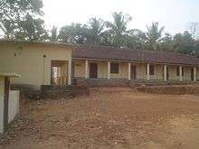
Poocholamadu Cheroor Srambia in Vengara | |
 Vengara  Vengara Location in Kerala, India | |
| Coordinates: 11°03′03″N 75°58′40″E / 11.050807°N 75.977679°ECoordinates: 11°03′03″N 75°58′40″E / 11.050807°N 75.977679°E | |
| Country |
|
| State | Kerala |
| District | Malappuram |
| Languages | |
| • Official | Malayalam, English |
| Time zone | IST (UTC+5:30) |
| PIN | 676 304 |
| Telephone code | 0494 |
| ISO 3166 code | IN-KL |

Vengara is a town in Malappuram district of Kerala state.
Official status
Vengara is a "special grade" panchayath in Malappuram district and is situated in Tirurangadi Taluk. It was famous for its spice trading. After the discovery of oil in the Gulf countries, many people from this place migrated to work in semi-skilled jobs that region, bringing prosperity to this part of Kerala.Jawahar navodaya vidyalaya is 4 km away from vengara town. The major roads like kondotty-kottakal road and parappanangadi-malappuram road meets the town.The city suffering due to traffic jam during entire day time even though high grade roads are available for transportation as compared to other western towns in malappuram district. In the recent delimitation of constituencies Vengara received an Assembly seat. Vengara is included in the Malappuram Loksabha constituency. Vengara is the headquarters of Vengara Block Panchayath. There is a sub-district with Vengara as headquarters in Malappuram educational district. Vengara is also home to a police station and a telephone exchange. Eventhough Vengara is a small town, most depend on other towns like Kottakkal, Tirurangadi & Chemmad for buying clothes, jewellery etc., which negatively affects business' in Vengara.
And Nearest Attractive Tourist places. Nilambur, Kadalundi Bird Sanctuary, Nedumkayam Rainforest, Adyanpara Waterfalls, Kodikuthimala, Mini Ooty, Kottakunnu
Education
Higher Secondary Schools Govt Girls VHSS Vengara and KMHSS Kuttoor North are within the boundary of Vengara Panchayath. Tirurangadi PSMO College, Chemmad Darul Huda university etc. are within 7 km from Vengara
Politics
Vengara Panchayath is ruled by the alliance of Indian Union Muslim League and Indian National Congress parties. Chakkeeri Ahemed Kutty(late) was from Vengara.
Vengara Panchayath includes 23 wards. Panchayath ruling council is Presided by KP Haseena Fasal (Muslim League)and PP Safeer Babu (INC) is vice president.
http://www.lsg.kerala.gov.in/election/candidateDetails.php?year=2010&lb=962&ln=ml
Geography
Vengara is spread on the banks of Kadalundi River, the third-longest river in Malabar after Bharathappuzha and Chaliyar. Oorakam Mala is the highest nearby hill. Vengara is 5 km from Tirurangadi, 6 km from Chemmad a major town in the district and 15 km from Malappuram and Parappanangadi. Kottakkal is 8 km from vengara.Kottakkal is famous for Kottakkal Arya Vaidya Sala. Other nearby towns are Manjeri(27 km) and Tirur(23 km).
People
The population is predominantly Muslims followed by Hindus, with few Christians. The major source of income is remittances from family members employed in Gulf countries. Other occupations include retail and agriculture.
Vengara people are all interested in Football. There are a number of football clubs like Vattathingal Vengara, Champions Vengara, MASC Parambilpadi, BASC Manatti, Town Team Vengara, Undas Kuttoor Kuzhichena,SHINE STAR PAKKADAPURAYA 4etc..
Villages in Vengara Taluk
- Abdul Rahiman Nagar and Edarikode
- Kannamangalam and Othukkungal
- Parappur and Thennala
Culture
Vengara village is a predominantly Muslim populated area. Hindus exist in comparatively smaller numbers. So the culture of the locality is based upon Muslim traditions. Duff Muttu, Kolkali and Aravanamuttu are common folk arts of this locality. There are many libraries attached to mosques giving a rich source of Islamic studies. Most of the books are written in Arabi-Malayalam which is a version of the Malayalam language written in Arabic script. People gather in mosques for the evening prayer and continue to sit there after the prayers discussing social and cultural issues. Business and family issues are also sorted out during these evening meetings. The Hindu minority of this area keeps their rich traditions by celebrating various festivals in their temples. Hindu rituals are done here with a regular devotion like other parts of Kerala.[1]
Transportation
Vengara village connects to other parts of India through Parappanangadi town. National highway No.66 passes through Parappanangadi and the northern stretch connects to Goa and Mumbai. The southern stretch connects to Cochin and Trivandrum. State Highway No.28 starts from Nilambur and connects to Ooty, Mysore and Bangalore through Highways.12,29 and 181. The nearest airport is at Kozhikode. The nearest major railway station is at Parappanangadi.