Velenjak
[1] Velenjak (Persian: ولنجک) is a neighbourhood, northwest of Tehran, in Iran.
About
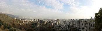
ٰVelenjak is located in the Shemiran area in the northernmost part of Tehran, on the slopes of the Alborz mountain range. It is known for its beautiful landscape, mild climate, fresh mountain air, springs, and wildlifem and is one of the most expensive neighborhoods in Tehran with a population of 79, 853, 900 people as of 2012.
Tehran's main transportation is by taxi. There are two types of taxis in Iran. “Darbast, " which will take you straight to your destination or "Shared Taxis, " where you share a taxi with random people who are going to multiple destinations that are close to each other. Shared taxis are cheaper starting at 2, 000 Toman. 3, 500 Iranian Toman is equal to 1 USD.
Usually the price of properties in this area is higher than that in most other suburbs of Tehran as well as the cost of living (although it varies depending on many regional factors). The houses in Velenjak range from ($350, 000) for a 100-meter (1, 000 square foot) house.
There are many places to visit near Velenjak.
| Shops/Restaurants/Recreation | Activities | Distance from Velenjak (km) | Distance from Velenjak (miles) |
|---|---|---|---|
| Tochal | Ski Resort | 1. 0 | .6 |
| Darreh Velenjak (Velenjak Valley) | Jogging | The Eastern Side of Velenjak | The Eastern Side of Velenjak |
| Tajrish | Shopping | 2. 6 | 1. 6 |
| Darband | Restaurants | 2. 9 | 1. 8 |
| Borj Milad | Multi-purpose Tower | 16. 5 | 10. 2 |
| Darakhe | Shopping | 1. 6 | .9 |
| Markaz Tejari | Shopping | .2 | .1 |
| Ab-o-Atash | Park | 8. 3 | 5. 1 |
| Palladium | Shopping | .6 | .3 |

Velenjak is located adjacent to the Tochal Complex, a ski resort area with a gondola lift up to Mount Tochal. Because of the popularity of the recreational facilities, visitors are advised that Velenjak is always overcrowded on Fridays. Tochal is one of biggest tourist destinations in Alborz Mountain adjacent to Velenjak. Thousands of people visit Tochal everyday. It is also busy during the summer. People walk up Tochal during the night time, it has many restaurants and coffee shops, and once you get to the very top there is a beautiful view of the whole city.

Borje Milad is the seventeenth tallest freestanding structure and the sixth tallest tower in the World. It has twelve floors and was opened in 2008. The Tower also has a magnificent view of Tehran.

Another huge landmark not too far from Velenjak is the Azadi Tower. The Azadi Tower means "Tower of Freedom". It was built to commemorate the 2, 500 years of the Persian Empire in 1971. It is a huge landmark in the capital of Tehran located in Azadi Square.
There are a wide variety of restaurants and coffee shops in Velenjak.
- Pardis Restaurant
- Shanli Restaurant
- Zood Food
- Merci Restaurant
You can also buy balal (grilled corn) which is found in the streets and parks
When visiting Iran, visitors should be aware of the dress code for both woman and men. Woman are to wear a hijab (a scarf that covers the hair and neck), and a loose mid-thigh length outfit that covers arms. Men cannot wear very tight shirts or short shorts. Though there are restrictions on what can be worn in public, Iranians have created a sense of style and fashion that abides by these rules.
Velenjak houses a large number of foreign residents, particularly people of South Korean descent who work in the finance and industrial firms throughout Tehran. Many embassies are located in Velenjak, including the embassies of Brunei, Côte d'Ivoire, Malaysia, Serbia and Montenegro, Algeria, and numerous ambassadorial residences. Shahid Beheshti University and Shahid Beheshti University of Medical Sciences, are also located in this area.
The University of Shahid Beheshti is located in Velenjak. It is known for their outstanding Engineering program. They also have Natural Sciences, Humanities, and Social Science programs.
The popular singer Benyamin Bahadori has stated that he is from Velenjak in an interview with Radio Javan.
See also
Coordinates: IR_type: city_source: GNS-enwiki 35°49′N 51°24′E / 35.817°N 51.400°E