Vayala
| Vayala | |
|---|---|
| Village town | |
|
St.George Church | |
| Coordinates: 9°43′0″N 76°35′30″E / 9.71667°N 76.59167°ECoordinates: 9°43′0″N 76°35′30″E / 9.71667°N 76.59167°E | |
| Country |
|
| State | Kerala |
| District | Kottayam |
| Government | |
| • Type | 4 |
| Languages | |
| • Official | Malayalam, English |
| Time zone | IST (UTC+5:30) |
| Postal Code | 686 587 |
| Telephone code | +91 4822 |
| Vehicle registration | KL-67 |
| Nearest city | Ettumanoor |
| Literacy | 100% |
| Lok Sabha constituency | Kottayam |

Vayala is a small town located in the Meenachil(Pala) Taluk of Kottayam district Kerala, India. It is approximately 5 kilometers from the village Kuravilangad, about 11 kilometers from Palai municipality town and about 25 kilometers away from district capital Kottayam.
History
It is believed that the name Vayala[1] is derived from the Malayalam word vayal meaning "paddy field".
Transportation network
Vayala is connected with the district headquarters Kottayam and other major cities. Public transport in the town is largely dependent on buses, run by private operators.
Ferries are a major mode of transport to the town with two major ferry jetties - Town Jetty and Kodimatha Jetty.
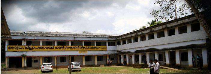
Schools
- Govt:V H S S Vayala
Churches & Temples
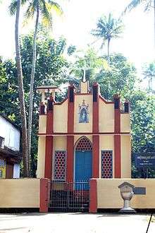
Vayala is located 10 km from Ettumanoor town and 6 km from Kuravilangdu Town. Vayala has three Hindu temples (Paruthurthikavu, Njaralappuzha Sree Dharma Sastha Temple, Thrikkayil Sree Subrahmanya Swami Temple) and a Roman Catholic church Syrian church (St. George Church,Vayala),[2][3] a Catholic Latin church (St. Marys Church, Vayala-Puthenangady), three Catholic Syrian chapels:St Joseph(Puthenangady,Vayala),St Xavier (Saviour Giri,Vayala), St Sebastian chappel(Thuruthimukku,Vayala),t and a Sacred Heart Convent.
Hospitals
Sacred Heart Catholic Nuns operated St. George Mount Hospital (,[4][5] )is the only Allopathic Hospital Facility available with Vayala. Also Vayala has a Govt. Veterinary Hospital, Govt. Ayurvedic Hospital[6] and two private operated Ayurvedic Hospitals(Vedasudha [7] and Omsree [8])
Neighbouring Major Cities & Towns
|