Waverley, Otago
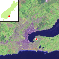
Waverley is a suburb of the New Zealand city of Dunedin. It was named after Sir Walter Scott's novel Waverley, first novel in a series known as the Waverley Novels, among the most popular and widely read English-language novels of the 19th century. Waverley is located at the start of the Otago Peninsula, 2.4 kilometres (1.5 mi) southeast of the city centre, on a rise overlooking the Otago Harbour to the north.
The suburb is connected to central Dunedin by several streets of which Larnach Road is the most prominent. This descends from the suburb to link with Marne Street on the eastern shore of the Andersons Bay Inlet. Marne Street connects with the suburbs of Andersons Bay and Musselburgh to the south, and in the north links with the causeway which carries Portobello Road from South Dunedin along the northern shore of the Otago Peninsula. Notable other roads linking Waverley and other suburbs include Doon Street, which winds down the steep slopes above the harbour to link Waverley with Vauxhall at Portobello Road, and McKerrow Street, which climbs from northeast Waverley to meet with Highcliff Road at the northern end of Shiel Hill.
The suburb stands on land which was owned by Dunedin early settler The Reverend Thomas Burns, whose dairy farm, Grant Braes, was located here. The farm was named for Burns's wife, whose maiden name was Grant. The original farmhouse still stands, incongruously surrounded by modern housing, and the area of Waverley close to the northern end of Belford Street is still known by the slightly amended name of Grants Braes. Today, the name is best known as that of a local football team, Grants Braes AFC, whose home ground is located 2 km (1.2 mi) to the southeast at Ocean Grove.
Vauxhall
The smaller suburb of Vauxhall surrounds the suburb on two sides, sitting on the point which juts out over the Andersons Bay Inlet to the southwest of Waverley and on a strip of Portobello Road which follows the Harbour coast to Waverley's northwest. This strip follows a fairly straight course as far as Vauxhall Yacht Club, then curves around a small bay before reaching Burns Point at the northernmost point of Vauxhall. Waverley continues to follow the higher slopes past Burns Point, but the coast road itself is sparsely populated from here as far as The Cove, 1.6 km (0.99 mi) to the east.
In the early years of Dunedin, The cliffhead overlooking Andersons Bay Inlet was the site of a colourful and notorious recreation area, the Vauxhall Gardens. Opened at the height of the Central Otago Gold Rush in 1862 and named for the gardens at Vauxhall in London, the gardens were the brainchild of wealthy local Henry Farley, who spent a then-astonishing £10,000 on their construction. The 23-acre (9.3 ha) site included a gymnasium, bandstands, dancing areas, and a funicular railway. A menagerie contained koalas, kangaroos, vultures and Tasmanian devils. The gardens were highly popular, but also became known for the rowdiness and drunkenness of the parties, and for prostitution. The gardens did not survive the end of the gold rush,. and were closed in 1870. No trace remains of them today.[1] The land was subdivided and today Vauxhall is a quiet residential suburb.
Two notable buildings stand in the harbourside stretch of Vauxhall. The Vauxhall Yacht Club is housed in a modern building at the southern end of the small bay which lies immediately to the south of Burns Point. Beyond it, in the centre of the bay's coast at the foot of Doon Street, is The White House, originally known as Dandie Dinmont. This building was owned by William Larnach and occupied by him during the construction of Larnach Castle. Larnach's intention was to turn the house into a hotel, the Dandie Dinmont Hotel, but these plans never eventuated. The building has been in a state of neglect for many years, but as of 2009 is undergoing a major restoration.
Education
- Grant's Braes School is a decile 10. It is a state co-educational primary school for year 1 to 6 children, with seven classrooms and has a roll of around 180 pupils. The school was opened in 1950.[2]
- Rotary Park School, another decile 10 school in the area, was closed in 2012 after declining enrolments.[3]
References
- ↑ Hayward, Paul (1998) Intriguing Dunedin Street Walks. Dunedin: Express Office Services. p. 25.
- ↑ www.grantsbraes.school.nz
- ↑ Otago Daily Times
Coordinates: 45°53′06″S 170°32′02″E / 45.88500°S 170.53389°E