Vaudreuil-Dorion
| Vaudreuil-Dorion | |
|---|---|
| City | |
 | |
 Location within Vaudreuil-Soulanges RCM. | |
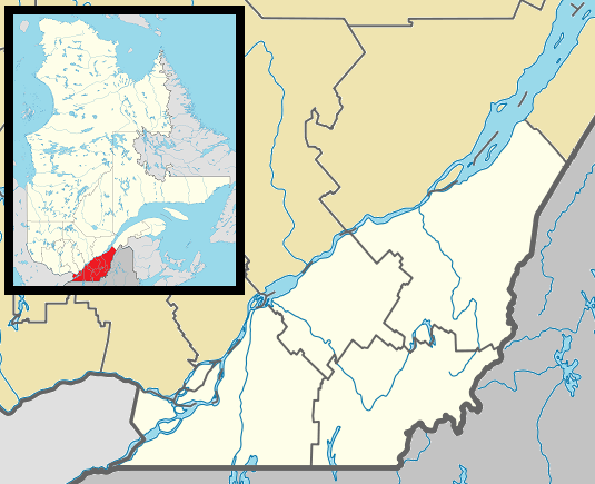 Vaudreuil-Dorion Location in southern Quebec. | |
| Coordinates: 45°24′N 74°02′W / 45.400°N 74.033°WCoordinates: 45°24′N 74°02′W / 45.400°N 74.033°W[1] | |
| Country |
|
| Province |
|
| Region | Montérégie |
| RCM | Vaudreuil-Soulanges |
| Constituted | 16 March 1994 |
| Government[2][3] | |
| • Mayor | Guy Pilon |
| • Federal riding | Vaudreuil-Soulanges |
| • Prov. riding | Vaudreuil |
| Area[2][4] | |
| • Total | 92.80 km2 (35.83 sq mi) |
| • Land | 72.52 km2 (28.00 sq mi) |
| Population (2011)[4] | |
| • Total | 33,305 |
| • Density | 459.3/km2 (1,190/sq mi) |
| • Pop 2006-2011 |
|
| • Dwellings | 13,292 |
| Time zone | EST (UTC−5) |
| • Summer (DST) | EDT (UTC−4) |
| Postal code(s) | J7T to J7V |
| Area code(s) | 450 and 579 |
| Highways |
|
| Website |
www vaudreuil-dorion |
Vaudreuil-Dorion is an off-island suburb of Montreal, in southwestern Quebec. It is located in the Vaudreuil-Soulanges Regional County Municipality. The result of the merger of two towns, Vaudreuil and Dorion, the municipality's population as of 2011 is estimated to be 33,305.
Vaudreuil-Dorion's population is growing quickly as farmland is converted to residential areas and commercial developments.
History
On 23 November 1702, governor of New France Louis-Hector de Callière gave a seigneury to Philippe de Vaudreuil, who was governor of Montreal at the time. Rigaud de Vaudreuil later became governor of New France.
In 1725, the region had only 38 inhabitants. About 1742 people began to be interested in the region and Vaudreuil's population rose. 381 people lived in Vaudreuil in 1765. With the creation of the Grand Trunk Railway, people began to live in Dorion, which was called Vaudreuil Station. Dorion became a village in 1891.
Dorion was bisected by Autoroute 20 which links Downtown Montreal and Toronto via Highway 401 in Ontario. The Canadian National Railway and Canadian Pacific Railway links between Toronto and Montreal are located in Dorion. Housing developments began in the 1950s and continued well into the 1970s. Throughout the 1980s and the 1990s, housing began sprouting north and east of Dorion.
Vaudreuil and Dorion merged in 1994, becoming the City of Vaudreuil-Dorion.
Geography
Vaudreuil-Dorion is located on the south shores of the Lake of Two Mountains at the confluence of the Saint Lawrence and Ottawa Rivers, just off the western edge of Île Perrot. The city consists of two non-contiguous parts: its eastern part is the larger main area along Lake of Two Mountains where the population centres of Vaudreuil and Dorion are located; the western portion is a smaller, more rural area that borders Rigaud.
Demographics
Population
| Canada census – Vaudreuil-Dorion community profile | |||
|---|---|---|---|
| 2011 | 2006 | 2001 | |
| Population: | 33,305 (+29.1% from 2006) | 25,789 (+29.5% from 2001) | 19,920 (+7.9% from 1996) |
| Land area: | 72.52 km2 (28.00 sq mi) | 72.50 km2 (27.99 sq mi) | 72.47 km2 (27.98 sq mi) |
| Population density: | 459.3/km2 (1,190/sq mi) | 355.7/km2 (921/sq mi) | 274.9/km2 (712/sq mi) |
| Median age: | 37.1 (M: 36.4, F: 37.8) | 36.8 (M: 35.8, F: 37.7) | 37.0 (M: 36.0, F: 37.8) |
| Total private dwellings: | 13,292 | 10,637 | 8,078 |
| Median household income: | $69,772 | $64,191 | $54,728 |
| References: 2011[4] 2006[5] 2001[6] | |||
| Historical Census Data - Vaudreuil-Dorion, Quebec[7] | |||||||||||||||||||||||||||||
|---|---|---|---|---|---|---|---|---|---|---|---|---|---|---|---|---|---|---|---|---|---|---|---|---|---|---|---|---|---|
|
|
| |||||||||||||||||||||||||||
Language
| Canada Census Mother Tongue - Vaudreuil-Dorion, Quebec[7] | ||||||||||||||||||
|---|---|---|---|---|---|---|---|---|---|---|---|---|---|---|---|---|---|---|
| Census | Total | French |
English |
French & English |
Other | |||||||||||||
| Year | Responses | Count | Trend | Pop % | Count | Trend | Pop % | Count | Trend | Pop % | Count | Trend | Pop % | |||||
| 2011 |
32,590 |
21,245 | |
65.19% | 6,495 | |
19.93% | 610 | |
1.87% | 4,240 | |
13.01% | |||||
| 2006 |
25,400 |
18,630 | |
73.35% | 4,160 | |
16.38% | 285 | |
1.12% | 2,325 | |
9.15% | |||||
| 2001 |
19,650 |
16,260 | |
82.75% | 2,635 | |
13.41% | 165 | |
0.84% | 590 | |
3.00% | |||||
| 1996 |
18,185 |
14,580 | n/a | 80.18% | 2,865 | n/a | 15.75% | 260 | n/a | 1.43% | 480 | n/a | 2.64% | |||||
Infrastructure
Transportation
The city is the point of intersection for two of Canada's busiest highways: Autoroute 40/Autoroute 540/Autoroute 20 (connecting the Quebec City-Windsor Corridor) and Highway 417 connects to Ottawa and Arnprior, Autoroute 20 and Highway 401 connects Toronto to Montreal and Autoroute 30 is Montreal's Southern Bypass.
Local bus service is operated by CIT La Presqu'Île, connecting to the Vaudreuil and Dorion stations on the Vaudreuil-Hudson commuter rail line.
Media
CJVD-FM operates studios in Vaudreuil-Dorion, broadcasting at 100.1 FM in the Vaudreuil-Soulanges, West of Montreal-Island (West-Island) and Valleyfield areas. On the air since September 2008, CJVD-FM airs a French and English hits format from 1970 to 1995, as well as the Sixties. It is also available on the Internet at CJVD.CA
Education
- École Sainte-Madelaine[9]
Sainte-Madelaine Elementary school was founded in 1960. It is located on Sainte-Madelaine street and has undergone substantial changes in 1991 through 1993 then again in 1997 through 1998. Furthermore, in 2005, the day care centre was enlarged to satisfy the growing demands of the school population. The school currently hosts elementary students for grades 3, 4, 5 and 6. There are 560 students attending the establishment.
- École St-Michel
- École Harwood
- École Marguerite-Bourgeoys
- École du Papillon-Bleu
- Pierre Eliott Trudeau Elementary School
- École Secondaire de la Cite-des-Jeunes
- École Hymne-au-Printemps
Notable people
- Christian Chagnon - handball player who competed in the 1976 Summer Olympics
- Meili Faille - politician
- André Hainault - soccer player, Canada and Houston Dynamo
- Constant Montpellier - jockey
- Norbert Murphy - archer, Paralympic bronze medalist
- Hormisdas Pilon - Quebec politician
- Sasha Pokulok - ice hockey defenceman
- Marc-André Servant - ice dancer
See also
References
- ↑ Reference number 287652 of the Commission de toponymie du Québec (French)
- 1 2 Ministère des Affaires municipales, des Régions et de l'Occupation du territoire: Vaudreuil-Dorion
- ↑ Parliament of Canada Federal Riding History: VAUDREUIL--SOULANGES (Quebec)
- 1 2 3 2011 Statistics Canada Census Profile: Vaudreuil-Dorion, Quebec
- ↑ "2006 Community Profiles". Canada 2006 Census. Statistics Canada. March 30, 2011. Retrieved 2014-02-19.
- ↑ "2001 Community Profiles". Canada 2001 Census. Statistics Canada. February 17, 2012. Retrieved 2014-02-19.
- 1 2 Statistics Canada: 1996, 2001, 2006, 2011 census
- ↑ http://www.mamrot.gouv.qc.ca/repertoire-des-municipalites/fiche/municipalite/71083/
- ↑ École Sainte-Madelaine
External links
- (French) Ville de Vaudreuil-Dorion
- http://www.adbvd.com - Vaudreuil Basesball Association
- Surrounding area - Hudson, Quebec
 |
Hudson | Vaudreuil-sur-le-Lac / L'Île-Cadieux | Lake of Two Mountains Oka Senneville L'Île-Perrot, Quebec |
|
| Saint-Lazare | |
Ottawa River Bridge to: Terrasse-Vaudreuil / Pincourt | ||
| ||||
| | ||||
| Les Cèdres | Pointe-des-Cascades | Ottawa River Notre-Dame-de-l'Île-Perrot |
| |
Hudson | | ||
| Rigaud | |
Saint-Lazare | ||
| ||||
| | ||||
| Saint-Lazare |
| Cities & Towns | |
|---|---|
| Municipalities | |
| Villages | |
| |