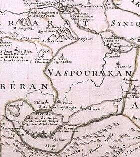
Vaspurakan
| Վասպուրական | |||||
| Province of Greater Armenia | |||||
| |||||
| Capital | Van | ||||
| History | |||||
| • | Artaxias I declaring himself independent | 189 BC | |||
| • | Conquered by Mongols | 13th century | |||
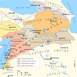
Vaspurakan (also transliterated as Vasbouragan in Western Armenian; Armenian: Վասպուրական, (Vaspourakan) meaning the "noble land" or "land of princes"[1]) was the eighth province of Greater Armenia, which later became an independent kingdom during the Middle Ages, centered on Lake Van. Located in what is now called southeastern Turkey and northwestern Iran, the region is considered to be the cradle of Armenian civilization.[1]
History
From the 9th century BC, Vaspurakan was part of Urartu. In the 6th century BC, it became part of Satrapy of Armenia. From 189 BC, it became one of Greater Armenia's provinces. Then it became part of Arsacid Dynasty of Armenia. After the division of 387, it was included into Persian Armenia. In the 8th century, it fell under Arab control. Many rebellions took place in Vaspurakan. In 885, within the territory of Kingdom of Armenia, it became free.
During most of its history, it was ruled by the Ardzruni dynasty, which first managed to create a principality in the area. At its greatest extent Vaspurakan comprised the lands between Lake Van and Lake Urmia (also known as Kaputan) in 908. In 908 Gagik I of Vaspurakan was recognized King of Armenia by the Abbasid Caliph in competition to the Bagratids, but soon he was reconciled with Ashot II, who recognized him as the King of Vaspurakan. In 1021, Seneqerim Ardzruni gave Vaspurakan to the Byzantine Empire, receiving estates in Sebasteia and surroundings in exchange.
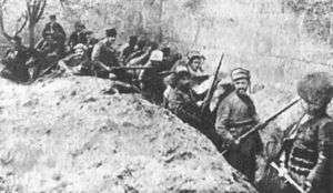
After Vaspurakan was ceded to the Byzantine Empire, it was conquered by Seljuq Turks. Laterly it was ruled by Ahlatshahs, Ayyubids and Sultanate of Rum successively. In the beginning of the 13th century, part of Vaspurakan was liberated by the Zakarids, but was then conquered by the Mongols, Seljuks, Kara Koyunlu, Kara Koyunlu, Iranian Safavids, and then by the Ottoman Turks (though Nader Shah regained it during his short lived Afsharid dynasty). Notable is the defense of Van of 1915 during the Armenian Genocide.
Cantons
Vapusrakan's territory was 40,870 km2 (16,000 sq mi) and was divided into 35 cantons. They usually took the name of the local nakharar (canton chief) that ruled them:
- Aghiovit
- Aghvandrot
- Akeh
- Andzakhidzor
- Antzevasiq - ruled by the Antzevatsi.
- Arberani
- Archishaovit
- Arnoyotn
- Artavanian
- Artashesian
- Artaz
- Atrpatunik
- Bagan
- Bujnunik
- Bogunik
- Darni
- Ervandunik
- Gavityan
- Gazrikan
- Gokhten
- Gukan
- Kirchunik
- Kughanovit
- Mardastan
- Metz Aghbak
- Metznunik
- Nakhichevan
- Rshtunik - ruled by the Rshtuni.
- Patspatounik
- Palouniq
- Taygirian
- Tchevashrot
- Tornavan
- Tosb
- Varajnuniq - ruled by the Varajnuni.
Sites of Interest
- The old city of Van
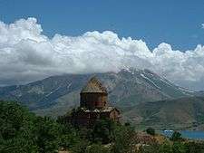
- Armenian Cathedral of the Holy Cross, former Armenian Catholicosate of Aghtamar on the Isle of Aghtamar
- Varagavank, an Armenian monastery on the slopes of Mt. Varag (9 km. east of Van), founded by King Sennacherib-John early in his reign (1003–1024). It became the richest and most celebrated monastery of the Lake Van area. Here, Khrimian Hayrik founded Arciv Vaspurakani (The Eagle of Vaspurakan), the first newspaper ever printed in Armenia. The archbishop of Van resided here until the late 19th century.
- Chapel of Dzordzor
- The Monastery of Saint Gregory the Illuminator, near Mount Varag
- Naregavank, a destroyed 10th-century Armenian monastery where Krikor Naregatsi is buried
- Karmravank, a 10th-century Armenian monastery on the shores of Lake Van
- Saint Gregory of Goms monastery, on the southern shores of Lake Van
- Saint Thomas Monastery, near the shores of Lake Van
- Saint Bartholomew Monastery
- The Church of the Holy Cross at Soradir
- Hayots Dzor (now Gürpınar plain), the valley in which the Armenian progenitor Hayk defeated the Assyrian king Bel
- Haykaberd, the castle constructed by Hayk in Hayots Dzor
- Plain of Avarayr
- Saint Thaddeus Monastery
- Saint Stepanos Monastery
Notable People from Vaspurakan
Gallery
- Medieval Armenian cathedrals and monasteries in Vaspurakan
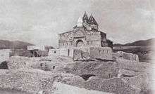
 The Cathedral of the Holy Cross (10th century) on Akdamar Island
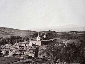 The Monastery of Narek (10th century) on the shores of Lake Van
 The Monastery of Saint Bartholomew (13th century)
 The Saint Thaddeus Monastery (14th century) in northwestern Iran
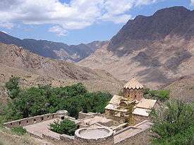 Saint Stepanos Monastery in northwestern Iran
References
- 1 2 Hovannisian, Richard G. (1999). Armenian Van/Vaspurakan. Costa Mesa, California: Mazda Publishers. ISBN 1-56859-130-6.
«Վասպուրական» Հայրենակցական միություն http://vaspurakan.blogspot.com/
Bibliography
- Hovannisian, Richard G., ed. (2000), Armenian Van/Vaspurakan , Historic Armenian Cities and Provinces , Costa Mesa, California: Mazda Publishers , OCLC 44774992
- Der Nersessian, Sirarpie. Armenia and the Byzantine Empire: a Brief Study of Armenian Art and Civilization. Cambridge: Harvard University Press. 1947.
Historical states and regions of Armenia | ||
|---|---|---|
| Independent Armenian states |
|  |
| Minor or dependent Armenian states |
| |
| Provinces or Ashkhars of Armenia Major | ||
| Other Armenian regions |
| |
| Other provinces under Tigranes the Great | ||
Coordinates: 38°48′N 44°00′E / 38.8°N 44.0°E