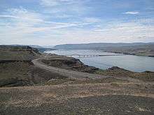
Vantage Bridge
The Vantage Bridge is a bridge in the U.S. state of Washington. It carries Interstate 90 across the Columbia River, near Vantage and George, Washington. This section of the river is named Wanapum Lake; it is the reservoir formed by Wanapum Dam. The bridge separates the Ginkgo Petrified Forest and Wanapum Recreational Area State Park on the western bank of the Columbia.
The current bridge is the second Vantage Bridge. The first was built in 1927 as part of the Sunset Highway (later US 10), a precursor to I-90. In 1962 the second bridge was built because the reservoir pool backing up behind the new Wanapum Dam would soon overwhelm the old bridge. The first bridge was dismantled. In 1968 its steel cantilever truss was reused for the Lyons Ferry Bridge, where SR 261 crosses the Snake River.[2]
References
- ↑ "Bridge List M 23-09" (PDF). Washington State Department of Transportation. June 2011. p. 191. Retrieved March 13, 2013.
- ↑ Dorpat, Paul; Genevieve McCoy (1998). Building Washington: A History of Washington State Public Works. Tartu Publications. p. 114. ISBN 0-9614357-9-8.
External links