Vanj District
| Vanj District Ноҳияи Ванҷ | |
|---|---|
| District | |
| Ноҳияи Ванҷ | |
 Location of Vanj District in Tajikistan | |
| Coordinates: 38°22′23″N 71°27′19″E / 38.37306°N 71.45528°ECoordinates: 38°22′23″N 71°27′19″E / 38.37306°N 71.45528°E | |
| Country |
|
| Province | Gorno-Badakhshan Autonomous Region |
| Capital | Vanj |
| Area | |
| • Total | 1,710.6 sq mi (4,430.5 km2) |
| Population (2008) | |
| • Total | 30,400 |
| as of 1 January 2008 | |
| Time zone | TJT (UTC+5) |
| Postal code | 736300 |
| Area code(s) | +992 3551 |
Vanj District or Nohiya-i Vanj (Tajik: Ноҳияи Ванҷ / Persian: ناحیۀ ونج) is a district in east Tajikistan, in the north-west of the Gorno-Badakhshan Autonomous Region, with administrative capital Vanj.
It is located east of the Panj River at the point where the Panj turns from north to west. It is roughly rectangular, tending to the southwest. It is bounded on the west by the Panj River and Afghanistan, on the northwest by Darvoz District, on the north by the Darvoz Range and Farkhor District of Khatlon Province, on the east (approximately) by the Academy of Science Range and Murghob District and on the south by the Yazgulem Range and Rushon District. It corresponds to the valleys of the Vanj River (north) and the Yazgulyam River (south), separated by the Vanj Range.[1]
The population of Vanj district is 30,400 (1 January 2008 estimate).[2]

References
| Districts | 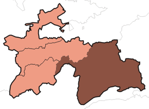 | |
|---|---|---|
| Main cities and towns | ||
| Geography | ||