Van Cortlandt Park–242nd Street (IRT Broadway–Seventh Avenue Line)
| Van Cortlandt Park–242nd Street | |||||||
|---|---|---|---|---|---|---|---|
| New York City Subway rapid transit station | |||||||
|
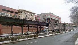
Looking south from the north end of the tracks, a 1 train enters Track 1. Another 1 train sits at Track 4. | |||||||
| Station statistics | |||||||
| Address |
West 242nd Street & Broadway Bronx, NY 10471 | ||||||
| Borough | The Bronx | ||||||
| Locale | Riverdale | ||||||
| Coordinates | 40°53′21″N 73°53′55″W / 40.889222°N 73.898583°WCoordinates: 40°53′21″N 73°53′55″W / 40.889222°N 73.898583°W | ||||||
| Division | A (IRT) | ||||||
| Line | IRT Broadway–Seventh Avenue Line | ||||||
| Services |
1 | ||||||
| Transit connections |
| ||||||
| Structure | Elevated | ||||||
| Platforms |
1 island platform (in service) 2 side platforms (unused) Spanish solution | ||||||
| Tracks | 2 | ||||||
| Other information | |||||||
| Opened | August 1, 1908 | ||||||
| Former/other names | 242 St–Van Cortlandt Park[lower-alpha 1] | ||||||
| Traffic | |||||||
| Passengers (2015) |
2,266,986[1] | ||||||
| Rank | 219 out of 422 | ||||||
| Station succession | |||||||
| Next north |
(Terminal): 1 | ||||||
| Next south |
238th Street (local): 1 Dyckman Street (express): no regular service | ||||||
| |||||||
| |||||||
|
242nd Street - Van Cortlandt Park Station (IRT) | |||||||
| Architect | Heins and Lafarge | ||||||
| Architectural style | Victorian Gothic | ||||||
| MPS | New York City Subway System MPS | ||||||
| NRHP Reference # | 05000226[2] | ||||||
| Added to NRHP | March 30, 2003 | ||||||


Van Cortlandt Park–242nd Street is the northern terminal station on the IRT Broadway–Seventh Avenue Line of the New York City Subway. Located at the intersection of 242nd Street and Broadway (US Route 9) in the Bronx, it is served by the 1 train at all times. It is adjacent to Van Cortlandt Park to the east, Manhattan College, and the 240th Street Yard of the subway system, along with the affluent neighborhoods of Fieldston and Riverdale to the west.
It was built from a design by subway architects Heins and Lafarge. Today it is the only remaining Victorian Gothic elevated terminal station on the subway, and contains the subway's only remaining scrolled station sign among its decorative flourishes. In 2005, it was listed on the National Register of Historic Places.
Station layout
| P Platform level |
Side platform, not in service | |
| Track 4 | (No service: Dyckman Street) | |
| Island platform, doors will open on the left or right | ||
| Track 1 | (No service: Dyckman Street) | |
| Side platform, not in service | ||
| M | Mezzanine | Station agent, MetroCard vending machines, fare control |
| G | Street Level | Exit/ Entrance |
The station is located 29 feet (8.8 m) above the west side of the street, where parking is located, on either side of where West 242nd Street intersects from the west. On that side of the street are commercial buildings, including a large parking garage on the southwest corner; the east side has the track, football field, tennis courts, swimming pools and other athletic facilities of Van Cortlandt Park. Also in the park nearby, to the northeast, is the Van Cortlandt House Museum, a National Historic Landmark. The 240th Street Yard is beyond the parking garage to the southwest, next to the campus of Manhattan College, a few blocks west of the station.
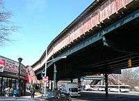
There are three components to the station: the platforms, a control house perpendicular to the tracks at the north end, and a crew quarters building spanning the platform at the south end. Two tracks widen into three just to the south, supported on steel girders and braces. From the northeast corner an overpass crosses the through-traffic lanes of Broadway. Two stairs descend in either direction from its end, matching the two stairs that descend to the sidewalk from the west of the control house.[3]
Just south of the station, the line widens to three tracks, which is the configuration up to just before Dyckman Street.
Platforms
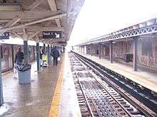
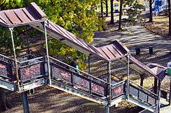
There is one island platform and two side platforms. The station was formerly set up as a Spanish solution with alighting passengers using the side platforms and boarding passengers using the island platform. Now, only the center island platform is open to the public for boarding and disembarking from trains. They are floored in concrete and sheltered with a wooden roof covered in standing-seam metal supported by trussed steel T-frames on the side platforms and timber in the center. Rounded rafter tails project from the eaves. The sides, except for the open southernmost section, have had metal windscreen added.[3]
Under the canopies are modern fluorescent lights. On the eastern platform, the original iron railings support original lights, with dish-shaped downlights on a curved stem. At the south end is the only scrolled station sign remaining anywhere in the subway system. The western platform has its original railing and modern lights.[3]
Control house
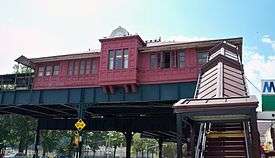
The control house is the dominant architectural feature of the station. The copper-clad timber frame exterior is painted in a vertical, batten seam pattern. It is topped with a low hipped roof clad in sheet metal and pierced by two ventilating dormer windows on the east and west side. A fleur-de-lis–patterned group of finials at the peak.[3]
On the north facade, narrow casement windows are echoed by recessed panels below. The groups of five in the section on either side of the projecting central bay window are flanked by blind openings. The bay is supported by corbeled brackets and topped with a fan gable above the overhanging eaves at the roofline. Its tripartite narrow windows are surrounded by recessed panels with inset circles on the sides and above.[3]
At both sides are steel frame parapets with wooden decks. These connect the western stairs and overpass to the control house. The stairs combine structural steel and decorative cast iron. Their supports are braced steel Tuscan columns. Gabled standing-seam metal canopies with box fluorescent lighting over the stairs are on narrow supports with slightly fluted capitals. At street level are gabled entries whose support columns are decorated with a geometric pattern similar to that on the control house's projecting bay window. C-shaped brackets support the original signage, now painted over.[3]
The steel-framed overpass is an architecturally sympathetic addition. Railings are a more restrained version of the original railings found on the platform. It is floored in wood plank and roofed with slats covered by standing seam metal. At its west end is a covered veranda leading into the control house.[3]
On the inside, the control house is floored in wood plank as well. The walls are finished in a mix of solid and tongue and groove wood paneling. Tall riveted steel arches support the ceiling. The main waiting area has niches where modern heaters have replaced the original pot-bellied stoves. There is a modern steel and glass token booth and turnstile bank, along with MetroCard vending machines. Former restrooms have been converted into utility and storage rooms.[3]
Crew quarters
The crew quarters building is located at the south end of the platforms. It is a one-story building sided in corrugated metal with a flat roof, elevated over the tracks and platforms at that end. The siding has been given the appearance of clapboard and painted gray. A belt course corresponding to the top of the windows has been painted red, the color of the Broadway–Seventh Avenue trunk line, on both side elevations; it is augmented with a series of blocks in the same color descending towards the tracks on the north end.[3]
At the south end, a series of projecting nested bays descends to an entrance to track level. To its south is an old signal house also sided in metal. The crew quarters can also be entered from the center platform. Its interior is given over to employee-related functions and is not open to the public.
Exits
At the north end of the station, past fare control, there are four stairs that lead down to Broadway. Two go to the west side of Broadway, and two go to the east side. These are the station's only exits.[4]
History
The station was built as part of the Contract 1 system erected from 1904–1908, connecting Lower Manhattan to the Bronx. Originally the northern terminus was intended to be Bailey Avenue and 230th Street, a block southeast of the current station at 231st Street. After the completion of the Harlem River Ship Canal at the end of the 19th century, the line was rerouted to a new terminus at 242nd Street. Like many of the other terminal stations in the outer boroughs, it was located near a park.[3]
Heins and Lafarge, who had already designed St. John the Divine near Columbia University and several buildings at the Bronx Zoo, were commissioned to design the stations. In the early 1890s the city's transit commissioners had recommended that subway stations be painted and decorated in order to make the experience of using the system pleasant. They took further inspiration from the contemporary City Beautiful movement, which called for beautiful public architecture in the hope that it would inspire citizens to act virtuously.[3]
Their use of the Victorian Gothic architectural style reflected its popularity at that time for train stations. The six elevated stations they built in that style on the Contract 1 are extensively decorated on their exterior surfaces, complementing the corresponding tilework and mosaics in the underground stations. 242nd Street, which opened on August 1, 1908,[5] is the only elevated terminal station left in that style from Contract 1.[3]
Within a few years of the station's opening, ridership on the line north of 157th Street increased sharply. In 1913 3.1 million tickets were sold at the Van Cortlandt Park station. Undeveloped lots along Broadway to the city's northern limit were quickly bought by builders hoping to profit from the boom in luxury houses, which could reach the subway through streetcar lines as well. At that time, it was expected that the line would be extended to 262nd Street.[6] The Horace Mann School was built to serve this population.[7]
In 1947, Jack Kerouac passed through the station, then a busy trolley hub, at the end of the first leg of his escape from the city in what became On the Road. His goal was to reach U.S. Route 6 at the Bear Mountain Bridge and use it as a route along which to go West to Denver. The attempt failed when he found very little traffic on Route 6 to hitch rides from, and he returned to the city to take a bus instead.[8]
See also
- List of New York City Subway terminals
- National Register of Historic Places listings in Bronx County, New York
Notes
- ↑ Used on platform signs and most R62A destination rollsigns
References
- ↑ "Facts and Figures: Annual Subway Ridership". Metropolitan Transportation Authority. Retrieved 2016-04-19.
- ↑ "NPS Focus". National Register of Historic Places. National Park Service. Retrieved December 24, 2011.
- 1 2 3 4 5 6 7 8 9 10 11 12 Howe, Kathleen (July 6, 2004). "National Register of Historic Places nomination, 242nd Street–Van Cortlandt Park Station". New York State Office of Parks, Recreation and Historic Preservation. Retrieved December 14, 2010.
- ↑ "MTA Neighborhood Maps: Riverdale" (PDF). mta.info. Metropolitan Transportation Authority. 2015. Retrieved 15 September 2015.
- ↑ "Our First Subway Completed At Last: Opening of the Van Cortlandt Extension Finishes System Begun in 1900". New York Times. August 2, 1908. Retrieved 16 August 2015.
- ↑ "The Real Estate Field". The New York Times. November 13, 1912. Retrieved December 16, 2010.
- ↑ "The Northward March of the Population and the Trade Along Broadway to the City Line". The New York Times. June 21, 1914. Retrieved December 16, 2010.
- ↑ Keller, Mitch (July 15, 2007). "City Lore: When On the Road was On the Subway". The New York Times. Retrieved December 16, 2010.
External links
| Wikimedia Commons has media related to Van Cortlandt Park – 242nd Street (IRT Broadway – Seventh Avenue Line). |
- nycsubway.org – IRT West Side Line: 242nd Street/Van Cortlandt Park
- nycsubway.org — Unknown Artwork From 2007 at Van Cortlandt Park — 242nd Street
- Station Reporter — 1 Train
- The Subway Nut — 242nd Street–Van Cortlandt Park Pictures
- 242nd Street entrance from Google Maps Street View
- Platforms from Google Maps Street View
| Topics |   | |
|---|---|---|
| Lists by county |
| |
| Lists by city | ||
| Other lists | ||
| ||