Vallo di Diano
| Cilento and Vallo di Diano National Park | |
|---|---|
| Name as inscribed on the World Heritage List | |
.jpg) | |
| Type | Natural |
| Criteria | C (iii) (iv) |
| Reference | 842 |
| UNESCO region | Europe |
| Inscription history | |
| Inscription | 1998 (22nd Session) |
The Vallo di Diano (also known as Valdiano) is an Italian valley of the south-eastern side of Campania, in the Province of Salerno.
Geography
Situated between the Alburni mountains and the borders of Campania with Basilicata, it is considered a geographical subregion of Cilento and is part of the Cilento and Vallo di Diano National Park, World Heritage Site of Italy from 1998. The greatest forestal park, mainly located in cilentan side, is Pruno.
The area is composed by 17 municipalities, and the greatest one is Sala Consilina, with c/a 15,000 inhabitants. The others are Atena Lucana, Auletta, Buonabitacolo, Caggiano, Casalbuono, Monte San Giacomo, Montesano sulla Marcellana, Padula, Pertosa, Polla, San Pietro al Tanagro, Sant'Arsenio, San Rufo, Sanza, Sassano and Teggiano.
Transport
The valley is served by the A3 motorway Naples-Reggio Calabria, with the exits of Petina,[1] Polla, Atena Lucana, Sala Consilina and Padula-Buonabitacolo. From this last exit it departs a speedway to Policastro Bussentino and Sapri with exits in Buonabitacolo and Sanza.
It was also served by the railway line Sicignano-Lagonegro, closed since 1987 for works and connected to Salerno–Potenza–Taranto railway line.
Photogallery
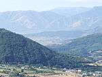 Vallo di Diano seen from Caggiano
.jpg) Panoramic view of Pertosa
Panoramic view of Pertosa View of Sala Consilina's Old Town. In background, the southern part of the valley
- Panoramic View of Teggiano
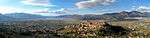 Panoramic View
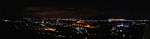 At night
Notes and references
- ↑ Partly in valdianese territory
See also
External links
![]() Media related to Vallo di Diano at Wikimedia Commons
Media related to Vallo di Diano at Wikimedia Commons
- (Italian) Cilento and Vallo di Diano National Park
- (Italian) Mountain Community of Vallo di Diano
| Provinces |  | |
|---|---|---|
| Places |
| |
| History | ||
| Politics and government | ||
Categories | ||

Coordinates: 40°24′N 15°34′E / 40.400°N 15.567°E