Valleyview, Ohio
| Valleyview, Ohio | |
|---|---|
| Village | |
|
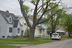
Village Hall | |
 Location of Valleyview, Ohio | |
 Location of Valleyview in Franklin County | |
| Coordinates: 39°57′54″N 83°4′22″W / 39.96500°N 83.07278°WCoordinates: 39°57′54″N 83°4′22″W / 39.96500°N 83.07278°W | |
| Country | United States |
| State | Ohio |
| County | Franklin |
| Area[1] | |
| • Total | 0.15 sq mi (0.39 km2) |
| • Land | 0.15 sq mi (0.39 km2) |
| • Water | 0 sq mi (0 km2) |
| Population (2010)[2] | |
| • Total | 620 |
| • Estimate (2012[3]) | 627 |
| • Density | 4,133.3/sq mi (1,595.9/km2) |
| Time zone | Eastern (EST) (UTC-5) |
| • Summer (DST) | EDT (UTC-4) |
| ZIP code | 43204 |
| Area code(s) | 614 |

- Not to be confused with Valley View, Ohio.
Valleyview is a village in Franklin County, Ohio, United States. The population was 620 at the 2010 census.
Geography
Valleyview is located at 39°57′54″N 83°4′22″W / 39.96500°N 83.07278°W (39.964863, -83.072761).[4]
According to the United States Census Bureau, the village has a total area of 0.15 square miles (0.39 km2), all land.[1]
The cities of Minerva Park, Bexley, Whitehall and Valleyview are enclaves of Columbus.
Demographics
2010 census
| Historical population | |||
|---|---|---|---|
| Census | Pop. | %± | |
| 1950 | 611 | — | |
| 1960 | 790 | 29.3% | |
| 1970 | 909 | 15.1% | |
| 1980 | 730 | −19.7% | |
| 1990 | 604 | −17.3% | |
| 2000 | 601 | −0.5% | |
| 2010 | 620 | 3.2% | |
| Est. 2015 | 636 | [5] | 2.6% |
As of the census[2] of 2010, there were 620 people, 246 households, and 148 families residing in the village. The population density was 4,133.3 inhabitants per square mile (1,595.9/km2). There were 266 housing units at an average density of 1,773.3 per square mile (684.7/km2). The racial makeup of the village was 90.0% White, 5.0% African American, 0.3% Native American, 0.8% Asian, 1.0% Pacific Islander, 1.9% from other races, and 1.0% from two or more races. Hispanic or Latino of any race were 4.4% of the population.
There were 246 households of which 30.9% had children under the age of 18 living with them, 37.4% were married couples living together, 13.8% had a female householder with no husband present, 8.9% had a male householder with no wife present, and 39.8% were non-families. 28.0% of all households were made up of individuals and 12.2% had someone living alone who was 65 years of age or older. The average household size was 2.52 and the average family size was 3.07.
The median age in the village was 39.4 years. 23.1% of residents were under the age of 18; 9% were between the ages of 18 and 24; 26.4% were from 25 to 44; 28.9% were from 45 to 64; and 12.6% were 65 years of age or older. The gender makeup of the village was 49.7% male and 50.3% female.
2000 census
As of the census[7] of 2000, there were 601 people, 258 households, and 168 families residing in the village. The population density was 3,957.6 people per square mile (1,547.0/km²). There were 267 housing units at an average density of 1,758.2 per square mile (687.3/km²). The racial makeup of the village was 96.17% White, 1.00% African American, 0.17% Native American, 2.33% Asian, and 0.33% from two or more races. Hispanic or Latino of any race were 0.17% of the population.
There were 258 households out of which 24.8% had children under the age of 18 living with them, 52.3% were married couples living together, 8.9% had a female householder with no husband present, and 34.5% were non-families. 28.7% of all households were made up of individuals and 11.6% had someone living alone who was 65 years of age or older. The average household size was 2.33 and the average family size was 2.86.
In the village the population was spread out with 21.5% under the age of 18, 5.2% from 18 to 24, 31.6% from 25 to 44, 26.5% from 45 to 64, and 15.3% who were 65 years of age or older. The median age was 40 years. For every 100 females there were 90.2 males. For every 100 females age 18 and over, there were 90.3 males.
The median income for a household in the village was $39,554, and the median income for a family was $45,455. Males had a median income of $31,842 versus $27,417 for females. The per capita income for the village was $19,445. About 3.0% of families and 5.7% of the population were below the poverty line, including 11.2% of those under age 18 and 4.0% of those age 65 or over.
References
- 1 2 "US Gazetteer files 2010". United States Census Bureau. Retrieved 2013-01-06.
- 1 2 "American FactFinder". United States Census Bureau. Retrieved 2013-01-06.
- ↑ "Population Estimates". United States Census Bureau. Retrieved 2013-06-17.
- ↑ "US Gazetteer files: 2010, 2000, and 1990". United States Census Bureau. 2011-02-12. Retrieved 2011-04-23.
- ↑ "Annual Estimates of the Resident Population for Incorporated Places: April 1, 2010 to July 1, 2015". Retrieved July 2, 2016.
- ↑ "Census of Population and Housing". Census.gov. Retrieved June 4, 2015.
- ↑ "American FactFinder". United States Census Bureau. Retrieved 2008-01-31.
External links
Municipalities and communities of Franklin County, Ohio, United States | ||
|---|---|---|
| Cities | 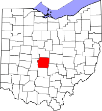 | |
| Villages | ||
| Townships | ||
| CDPs | ||
| Unincorporated communities | ||
| Footnotes | ‡This populated place also has portions in an adjacent county or counties | |