Vallée des merveilles

Landscape of the Vallée des Merveilles seen from the Baisse de Valmasque
The Vallée des Merveilles, also known in Italian as the Valle delle Meraviglie (English: Valley of Marvels), is a part of the Mercantour National Park in southern France. It holds the largest quantity of open-air Bronze Age petroglyphs in Europe, after Val Camonica in Italy, and is given special note for the area's inclusion for the European Diploma of Protected Areas.[1]
Location
The valley is located in the rugged mountains of the Argentera massif within the Maritime Alps north of the Italian Riviera.[2] The mountainous area was part of Italy until the end of World War II when it became part of France, hence the use of both languages for the place names.
Petroglyphs
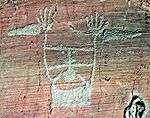
The petroglyphs (rock engravings), located on stone outcrops within the valley, were first identified by British amateur archaeologist Clarence Bicknell in 1881. Between 1897 and 1902, Bicknell copied and catalogued more than 10,000 drawings.
Beginning in 1967, an extensive study of the petroglyphs was begun by French archaeologist Henry de Lumley. De Lumley and a team of his postgraduate students classified the petroglyphs in the 40 km² area, with the greatest concentration in a 14 km² archaeological site on the slope of Mount Bégo. the engravings display objects like daggers, axes, and scythes. Suns, stars and spirals are represented. Ovals with criss-crossed lines may represent land or the earth. Some anthropomorphic figures have been found. The most common drawings are of horned animals.[2]
Henry de Lumley has theorized the petroglyphs are the work of a Mediterranean Bronze Age people who worshipped the bull and for whom Mount Bégo was a sacred site.[3]
The Musée des Merveilles at Tende houses numerous castings of the petroglyphs.
| Examples of Petroglyphs at Vallée des Merveilles |
|---|
| "The rock with one burst" |
| A plough, two animals and a man |
|
References
External links
Coordinates: 44°4′34″N 7°26′18″E / 44.07611°N 7.43833°E / 44.07611; 7.43833