Vale of Avoca
| Vale of Avoca | |
|---|---|
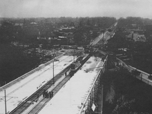 Vale of Avoca nears completion, November 3, 1924 | |
| Coordinates | 43°41′21″N 79°23′20″W / 43.689160°N 79.388882°WCoordinates: 43°41′21″N 79°23′20″W / 43.689160°N 79.388882°W |
| Carries |
5 lanes of St. Clair Avenue (originally 4 lanes with 2 streetcar tracks) |
| Crosses | Avoca Ravine |
| Locale | Toronto, Canada |
| Other name(s) | St. Clair Viaduct |
| Maintained by | Toronto Transportation |
| Characteristics | |
| Design | Truss arch bridge |
| Total length | 155.1 m (509 ft) |
| Width | 19.7 m (65 ft) |
| Clearance above | 27 m (89 ft) |
| Clearance below | Yellow Creek |
| History | |
| Opened | 1924 |
| Statistics | |
| Daily traffic | St. Clair Avenue East |
| Toll | No |
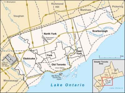 Vale of Avoca Location in Toronto | |
The Vale of Avoca is the name of a deep ravine and of a large viaduct which carries St. Clair Avenue East over the ravine, in Toronto, Canada. The bridge is located just east of Yonge Street. The current triple arch bridge, also known as the St. Clair Viaduct, was built to connect the well-established community of Deer Park with the developing community of Moore Park. The bridge replaced an older structure and straightened the alignment of St. Clair Avenue in the process. The bridge and ravine are named after a poem by Thomas Moore. A small channelized tributary of the Don River, known as Yellow Creek, weaves beneath the central span. Much of David A. Balfour Park (named for aToronto city councilor) consists of a nature trail that winds through the Vale of Avoca Ravine; the park also includes a grassy recreational area near an inlet into which Yellow Creek flows.
History
The first bridge over the Vale of Avoca was an iron bridge, built in 1888. The bridge was built by John Thomas Moore in the hopes of encouraging investment in his new subdivision, Moore Park. Under the condition that he build the bridge, the Township of York purchased a strip of land across the valley and leased it to Moore, who was in return given the St. Clair Avenue right-of-way between Avoca Avenue and Inglewood Drive.[1]
On December 16, 1912, Moore Park was annexed into Toronto at the instigation of landowners eager to obtain municipal services. Due to growing safety concerns regarding the old iron bridge, Toronto City Council authorized construction of a new bridge in 1922. Unlike the old bridge, this one would follow the straight alignment of St. Clair Avenue East (renamed in 1914). Two houses were expropriated and demolished, and the new structure built over two years at the cost of $716,653.58 ($8,914,622.90, adjusted for inflation) It opened to traffic in November or December, 1924.[2]
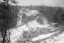
The old bridge remained open and operational throughout, with traffic detouring around construction on the eastern side. The former structure crossed the valley on an angle, beginning at St. Clair in the east and crossing to Pleasant Boulevard; it followed an electric line already in place. The eastern abutment and several concrete footings are still in place near the rim of the ravine as reminders of the old bridge.[3] After completion of the new structure, the old one was promptly dismantled, and the material used to forge the fence that lines Avoca Avenue along the west side of the ravine. The Yellow Creek stream at the bottom was subsequently channelized to slow erosion.[3]
In 1973, the City of Toronto officially named the bridge structure and the ravine as The Vale of Avoca,[1] after either the poem by Thomas Moore (after whom John Thomas Moore is named), or the River Avoca river valley in Ireland.[4] The bridge was renovated in 1985.[4]
References
- 1 2 Chartash, David (2001). "Report on the Vale of Avoca - Old History of the Place and Surrounding Area". Deer Park Newsletter. Retrieved December 27, 2010.
- ↑ Two photos from the Toronto Archives taken on November 3 and December 16 show the paving of the completed structure, and the demolition of the old structure, respectively.
- 1 2 Bridge over Vale of Avoca. Deer Park Library. Local history reference; 'Bridges' fonds
- 1 2 "St. Clair Viaduct". Lost River Walks Toronto. Retrieved December 27, 2010.
| Crossing the Rouge River | |
|---|---|
| Crossing the Don River | |
| Pedestrian | |
| Other bridges over waterways | |
| Other |
|