Vaal River
| Vaal | |
| River | |
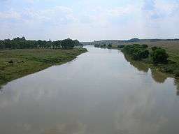 The Vaal River seen from the N3 national freeway, upstream from the Vaal Dam. Here it forms the border between the Mpumalanga and Free State provinces. | |
| Country | South Africa |
|---|---|
| Regions | Free State, Gauteng, Northern Cape, Mpumalanga |
| Tributaries | |
| - left | Vet River |
| Landmarks | Vredefort crater, Vaal Dam |
| Source | |
| - location | Near Breyten |
| Mouth | Orange River |
| - location | Near Douglas |
| - elevation | 1,241 m (4,072 ft) |
| - coordinates | 29°4′15″S 23°38′10″E / 29.07083°S 23.63611°ECoordinates: 29°4′15″S 23°38′10″E / 29.07083°S 23.63611°E |
| Length | 1,120 km (696 mi) |
| Basin | 196,438 km2 (75,845 sq mi) |
| Discharge | for Orange River |
| - average | 125 m3/s (4,414 cu ft/s) |
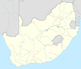 Location of the Vaal River mouth | |
The Vaal River (pronounced /ˈfɑːl/ and alternatively /ˈvɑːl/, especially by English speakers) is the largest tributary of the Orange River in South Africa. The river has its source near Breyten in Mpumalanga province, east of Johannesburg and about 30 kilometres (19 mi) north of Ermelo and only about 240 kilometres (150 mi) from the Indian Ocean.[1] It then flows westwards to its conjunction with the Orange River southwest of Kimberley in the Northern Cape. It is 1,120 kilometres (700 mi) long, and forms the border between Mpumalanga, Gauteng and North West Province on its north bank, and the Free State on its south.
Tributaries
Some of its tributaries include the Harts River, Vals River, Waterval River, Bamboes Spruit, Blesbokspruit, Mooi River, Vet River, Renoster River, Riet River, Klip River and Wilge River.[2][3][4]
Importance to industry and agriculture
Water is drawn from the Vaal to meet the industrial needs of the Greater Johannesburg Metropolitan Area and a large part of the Free State. As a part of the Vaal-Hartz Scheme it is a major source of water for irrigation. Water drawn from the Vaal supports 12 million consumers in Gauteng and surrounding areas.[5]
History
Excavations within the valley of the river have located pebble tools.[6]
Historically, the river formed the northern border of Moshoeshoe I's Basotho kingdom at its height in the mid-19th century, then became the boundary between two Boer republics: The South African Republic (later the Transvaal province) and the Orange Free State. The geographic name "Transvaal" comes from the name of this river, meaning "beyond the Vaal river". This was in respect to the Cape Colony and Natal, which were the main areas of European settlement at the time, and which lay south of the Vaal.
Naming
Vaal is a Dutch name (later Afrikaans), translated by the Griquas or Boers[7] from an earlier Kora Khoikhoi name Tky-Gariep (/hei !garib, drab river).[8] Both Vaal and Tky mean "drab" or "dull", which alludes to the colour of the waters, especially noticeable during flood season when the river carries a lot of silt. In the upper reaches the river was named Likwa (Sindebele), Ikwa (isiZulu), ilikwa (siSwati), lekwa (Sesotho), or cuoa by the Khoikhoi, all referring to the plain it traverses.[8]
Basin ecology
According to Hogan the headwaters portion of the basin supports high endemism in reptiles, and lower in the watershed are elevated levels of endemism for small mammals.[9]
See also
References
- ↑ Times Comprehensive Atlas, 12th ed. Times Books, London, 2007
- ↑ Upper Vaal WMA 8
- ↑ Middle Vaal WMA 9
- ↑ Lower Vaal WMA 10
- ↑ State of the Environment of South Africa (SOESA), Annual National State of the Environment Report
- ↑ Langer, William L., ed. (1972). An Encyclopedia of World History (5th ed.). Boston, MA: Houghton Mifflin Company. p. 9. ISBN 0-395-13592-3.
- ↑ Thompson, G. (1827). Travels and Adventures in Southern Africa I. Henry Colburn,London. p. 74.
- 1 2 du Plessis, E.J. (1973). Suid-Afrikaanse berg- en riviername. Tafelberg-uitgewers,Cape Town. pp. 326, 221. ISBN 0-624-00273-X.
- ↑ C. Michael Hogan. 2013. Vaal River. ed. P. Saundry. Encyclopedia of Earth. National Council for Science and the Environment. Washington DC
External links
| Wikimedia Commons has media related to Vaal River. |
- Parys.info
- Parys on the Vaal
- Vaal Meander
- Vaal River Cruises
- Vaal River Properties
- Vaal de Grace Estate
- University Campus on banks of Vaal river