Quaianlagen (Zürich)
| Quaianlagen | |
|---|---|
| Quaysides and Urban park | |
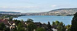 Lake Zurich's lower lake basin, looking north from Wollishofen towards the inner city of Zurich (August 2011) | |
| Design: | Arnold Bürkli |
| Construction: | 1881-1887 |
| Opening date: | Open all year |
| Length: | about 3 kilometres (1.9 mi) |
| Owner: | City of Zürich |
| Manager: | Grün Stadt Zürich |
| Location: | Zürich, Switzerland |
| Coordinates: 47°21′N 8°32′E / 47.350°N 8.533°E | |
Quaianalagen (German, plural; English: quays, or quaysides; from French: des quais), or Seeuferanlagen (German, plural for lakeshore sites) on Lake Zurich (German: Zürichsee), are lakefronts in the Swiss city of Zürich. Inaugurated in 1887, the quaysides are an important milestone in the development of the modern city of Zürich. The construction of the lake front was transformed from the medieval small town on the rivers Limmat and Sihl to an attractive modern city on the Lake Zurich shore. The project was managed byunder the city engineer Arnold Bürkli.[1]
Geography
The quais are situated in the districts of Enge, Seefeld and Wollishofen at the lower Lake Zürich shore within the city of Zürich. The complete construction includes, among others, the central Bürkliplatz on the outflow of the Lake Zurich, and (from west to east coast) Saffa-Insel, Strandbad Mythenquai,[2] Belvoirpark, Mythenquai, Arboretum, General-Guisan-Quai, Sechseläutenplatz, Utoquai, Seebad Utoquai,[3] Seefeldquai, Riesbach Harbour, Centre Le Corbusier, Blatterwiese, Chinagarten, Zürichhorn, Strandbad Tiefenbrunnen[4]
The lower lake basin also houses four of the huge Prehistoric pile dwellings around Lake Zurich of the transnational 111 serial sites. Probably the majority of the important sites of the Horgen culture are situated on lakeshore, including Grosser Hafner on a former lake island and Kleiner Hafner on a peninsula at Sechseläutenplatz respectively at the outflow of the Lake Zurich,[5] and Alpenquai,[6] within an area of about 0.2 hectares (0.49 acres) in the city of Zürich.[7][8]
Further points of interests
Blatterwiese
Blatterwiese is a wide popular neighborhood meadow situated between Seefeldquai and Zürichhorn, established in 1839 as a fabrication area, and since then also used as on open public lido. In 1926 the city government acquired the land and broke off the factory building, in 1939 it was the location of the Swiss National Exhibition Landi39, and also used for the G59 exhibition in 1959. After the horticultural exhibition, the open parkland was taken over by the city government and transformed to a large playground. Between Blatterwiese and Bellerivestrasse, in 1993 the Chinese Garden Zürich was inaugurated.[9] The construction of the new designed Spielplatz Blatterwiese was started in October 2006 in a construction period of about seven months, and opened in June 2007. Coordinated with the transformation of the playground adjacent, the former partially underground cable car station of the G59 exhibition,[10] was rebuilt in a so-called ZüriWC, a public toilet.[11] The Centre Le Corbusier or Heidi Weber Museum, an art museum dedicated to the work of the Swiss architect Le Corbusier, is situated opposite of the playground.
General-Guisan-Quai
The Alpenquai on the left bank – renamed General-Guisan-Quai[12] after Henri Guisan in 1960 – was created as a terraced-like promenade for the urban population, and four rows of trees were planted. On occasion of the renovation in 2003, the 20th century asphalt surface was replaced by the original gravel pathways. The original trees, three rows of double flowered Aesculus hippocastanum Baumannii whose special crown molding significantly characterize the appearance of the place. To keep up the same basket-like crown molding as the elderly chestnut, the young trees are capped at their historical model of the main trunk, the runners are moved to the desired quirl-like crown molding. In combination with the intervening series of trumpet trees of the species Catalpa bignonioides and Catalpa ovata, the image of a compact roof tree is achieved.[13]
Works of art from three generations adorn this path segment: the sculpture of Ganymede by Hermann Hubacher (1959) on the so-called Bürkliterrasse,[14][13] named after Arnold Bürkli, at Quaibrücke, as well as the fountain bowl of pink concrete by Christoph Haerle (2003, popurlay known as female Ganymede) and finally the mosaic fountain by Alfred F. Bluntschli (1903) to the east at the Arobetum.[13]
Hafen Enge
The Hafen Enge, meaning the harbour area in Enge (Zürich) is situated between the Arboretum and Strandbad Mythenquai. The harbour itself is as the Riesbach harbour used as a private-owned marina.[15] There are situated the Restaurant Quai61 and a very popular snack bar at the parking facility adjoint to the Arboretum, also housing a ZüriWC.[11] The harbor is in three sections, beginning at the Arboretum, at the parking facility and towards the Mythenquai there are four boathouses, usually just for members, and on the parking facility at the Mythenquai lido, it is allowed to also park private boats in the winter season. The most popular sculpture there is the so-called Züri-Leu, a colossal statue of a lion renewed in 2013, situated at the wave-breaker, that is accessible for the public.[16]
Hafen Riesbach
The Hafen Riesbach, meaning Riesbach harbour area is situated between Seefeldquai and Blatterwiese. The harbour itself is as the Enge harbour used as a private-owned marina. 2004, the old kiosk at the popular open lido at Riesbachstrasse was replaced by a remarkable building having an open windowed front area. The new polygonal pavilion was designed by the architects Andreas Furrimann and Gabrielle Hächler,[17] and now houses a small restaurant and as before an annexed public toilet ZüriWC.[11] The color of the windows is determined by the surrounding nature, and in the evening hours, the pavilion is illuminated. The 200 metres (656 ft) long, yet original renovated seawall front, had to be fully renewed because the risk of collapse in 2003 and 2006, thus the natural stone dry wall was rebuilt in the same way. The Seefeldquai is an important milestone in the work of the landscape architect Willi Neukom, as it combines park designs from different design periods. The stone pillar Klausstud originally stood in the lake and served as a border designation of the medieval right of ban of the city republic of Zürich. At that place also ended the fishing rights of the urban fishermen, and from here the Einsiedeln Abbey pilgrims proved their honour to the Protestantic city by lowering the volume of their prayers and songs. Since the landfills in the construction of the quais, the pillar stands in the middle of the park. The sculpture by Henry Moore is named Sheep Peace, and was donated in 1976.[17]
Landiwiese
Named after the Landi39 exhibition, there have been and still are held various public events, so the camp of the Circus Knie when it stages at Sechseläutenplatz, numerous youth events, Zürcher Theater Spektakel, and one of the most 'exotic', the so-called SAFFA exhibition in 1958, and the still very popular Saffa-Insel that is connected by a small bridge for thousands of people who like to swim or just have fun there. Landiwiwse includes a large open meadow with an integrated, smaller hard court for sports, and is home to valuable old trees. The festival site is part of the last replenishment on the left lake shore: In 1939 it was named for the Swiss National Exhibition (Landesausstellung), and expanded to its present size.[18] Mädchen mit erhobenen Händen is the most remarkable sculpture at the area; a work of Hermann Haller created in 1939.
Mythenquai
Otto C. Banninger's Gottfried Keller memorial (1964) is situated at the so-called Wabengarten, an 'honeycomb' water installation, one of the few relics of the garden exhibition G59 in 1959. It has been constructed only for a temporary exhibition, so reductions for bad foundations and water loss occurred in the less dense pools. Just a few steps from the seaside there's another rare plant in Zürich, Taxodium distichum having pneumatophores, originating from Mississippi River up to Missouri. At the marina there were planted Alnus glutinosa after the flood in May 1999, because the high water table in the vicinity of the lake gets better than their commitments, a group of Paulownia tomentosa. In 2004 the city council (Stadtrat, Zürich's executive organ) decided to develop a master plan for this area of the lakeside promenades.[13] Because the adjacent lake police (Wasserschutzpolizei der Stadt Zürich) planned a new building,[19] and the public access to Mythenquai had to be reorganized, a general upgrading and redevelopment of the whole area was planned around to the vaste parking facilities towards,[13] last but not least, Strandbad Mythenquai, Zürich's only lido that has a sand beach.[2]
Seefeldquai
The Seefeldquai consists of the popular and historic promenade between Utoquai and Feldeggstrasse at the lakeside environment of the 1970s, leading to Lindenstrasse, opposite of the Mythenquai. It is the southernly extensions of the long promenades from Utoquai, having emerged beaches with sand and gravel areas. Due to fluctuations in the water level, some shore sections had to be secured with boulders. The upright stone pillar Klausstud, named after Saint Nicholas, was the former Bann (boundary) of the medieval city of Zürich, situated nearby the Riesbach harbour. The 1864-built bathhouse had to be closed in 1887, but as a substitute of the former Riesbach local authorities approved the construction of two new baths, Strandbad Tiefenbrunnen and Seebad Utoquai. From 1975 to 1977, the waterfront between Feldeggstrasse and Lindenstrasse was redesigned by the landscape architect Willi Neukom. The park was designed with sink, hills and sandstone blocks and smooth transitions to the private property in the present Seefeld district. The curved routing at the Utoquai roadway, one of the busiest in Zürich, has been set in deliberate contrast to the orthogonal orientation of the paths towards Zürichhorn and Blatterwiese, and was paved with time typical hexagonal paving stones. The trees have been integrated into the new designed area and supplemented with 'unusual' trees, such as beech and hanging pyramidal elms and Rhododendrons and Azaleas, additional shrub and rose plantings, Irises, grasses and bamboo plantations. In 1999 it was replaced by a more transparent planting, and in 2007 the park area was again upgraded with rose plantations.[17]
Utoquai
The Utoquai is situated between the effluence of the Limmat and Bellevueplatz respectively the Sechseläutenplatz (Kleiner Hafner) squares, and the Seefeldquai adjoint to its southeast. The promenade was built in 1887 and planted with Chestnut trees as a lawn towards the Seebad Utoquai. It was formed as a high seawall with a wrought iron railing, and in small stairs led to the lake shore. Traffic planners urged to a masterplan in the 1960s, and so the adjacent Bellerivestrasse had to be broadend caused to the rapidly grown road traffic, but, however, not to be borne by the historic lakeside promenade. As a substitute, the definition of a shifted promenade was commissioned, but thanks to the project plans that partially were not realized, the design of the present wide construction, resting on concrete piles slab directly above the water level, was implemented in 1971, but the promenading shady chestnut trees of 1887 were preserved, and the waterside path of the 1970s became an additional part of the promenades. In 2006 the historic seawall was renewed, and the Utoquai's design is now from different time periods. As the old bathhouse had to make place for the construction of quais, the then independent municipality Riesbach built two new bathing facilities Strandbad Tiefenbrunnen (1886) and Seebad Utoquai (1890).[4][3] For the latter, a bathing palace on stilts with delicate, tower-like structures in the Moorish style was implented. For the first time in Zürich, it was allowed to men and women to bathe in the same bath. In 1942 the towering domes were added by sun terraces, also in a wooden construction, were built, and the basic structure of the original bathroom is still preserved. The Utoquai figures in Inventar der schützenswerten Gärten und Anlagen von kommunaler Bedeutung, being the inventory of estimable gardens and grounds of local importance that was established in 1989.[20]
History

The site of the former Kratzquartier accommodation and Bauhaus district at the Bauschänzli, the today's Stadthausanlage, was extended in 1833 by landfill with rubble of the Baroque city fortification along the lake shore. This also marked the end of the medieval Kratzquartier as the distinctive urban axis, extending from Zentralhof, Kappelerhof and Münsterhof towards the Bürkliterrasse, where once the not priviligued citizens of Zürich were living. The medieval quarter has been thoroughly overhauled between 1836 and 1900, and was over that large area entirely broken for purpose of 'modern lakeshore city'.[21][22][13]
By the thunder of cannons, the population welcomed the decision of the community votes of the then city of Zürich, and the then independent municipalities of Enge and Riesbach, the construction of the planned lakeside promenades on Sunday, 4 September 1881. The visionary project, which comprised the whole lower lake basin by the Zürichhorn close to the Enge port, was an enormous financial risk for the three communities that were involved. Smart financing models and the unwavering optimism of the early years however brilliantly mastered this challenge.[13]
The large-scale dumping works began in the area of Utoquai in the 1860s, and a total of 24.1 million cubic meters of stone material and lake mud for an about 200,000 square metres (49 acres) area were needed, which were brought in by ship and introduced by machines that were specially designed for this purpose. The typical procedure was to construct a breakwater and to backfill it with less stable lake marl.[23] The railway construction and the excavations of tunnels and cuts in Riesbach provided also the material, as well as the municipalities and private were invited to deposit rubble; large quantities were compensated at all.[13]
Arnold Bürkli-Ziegler, who then gave up his position as city engineer, became the chief engineer and coordinator. The construction work began in late 1881, since it was planned to present parts of the quays at the Swiss national exhibition of 1883. But before, the whole coastal zone had to be transformed into a time-consuming and costly process in public ownership. Until then, nearly the whole lake area was inaccessible for the public, because the terrain belonged to private owners on the shores of the lake: "Zürich had a lake, but it" [the city] "did not see it, and his position" [for the public] "was almost a secret", so a contemporary comment.
The inauguration was held in July 1887, and Quaibrücke became the link between the left (Limmat downstream respectively southernly) and right side of the lake. Because the elegant promenade of Utoquai, Bürkliterrasse (Alpenquai) respectively the General-Guisan-Quai lined up on the right side of the lake. The Arboretum, as a spacious park facility,[13] became the southernly connection towards Mythenquai and present Wollishofen.[13]
The Swiss National Exhibition in 1939 initiated the further extensions of the existing plant. A monorail was built between the two shores of the lake, but was already taken down shortly after the exhibition. At Zürichhorn the popular tourist restaurant Casino Zürichhorn was removed temporarily to provide space for the temporary buildings of the exhibition, one of which was preserved as the Fischerstube restaurant. On the fallow area between the railway station Tiefenbrunnen and Zürichhorn, in the 1950s the Seebad Tiefenbrunnen' lido was erected, and in the 1960s the new building of the today's restaurant Lakeside and the Centre Le Corbusier. As part of the horticultural exhibition 1959 (G59), Seefeldquai learned the most important changes: The present natural embankment design in the English landscape style between Riesbach harbor and Zürichhorn and the at that time nearly century-old trees were removed, as well as all embankments and replaced with sandstone slabs and stones. In the mid-1960s, some owners sold their property at Seefeldquai at the height of the Riesbachstrasse harbour area; in its place emerged several corporate offices and the private clinic Seepyramyde.[23] The last extension was the Chinagarten Zürich at Zürichhorn.
Literature
- Gartenbiografien: Orte erzählen. vdf Hochschulverlag AG, ETH Zürich, Zürich 2013, ISBN 978-3-7281-3579-7.
- Roman G. Schönauer: Von der Stadt am Fluss zur Stadt am See. 100 Jahre Zürcher Quaianlagen. Verlag Matthieu (Zürcher Heimatschutz), published by Stadtrat, Zürich 1987/2006, ISBN .
References
- ↑ "Arboretum" (in German). Grün Stadt Zürich, Arboretum Zürich. Retrieved 2014-12-28.
- 1 2 "Strandbad Mythenquai" (in German). Schul- und Sportdepartement Stadt Zürich. Retrieved 2014-01-04.
- 1 2 "Seebad Utoquai" (in German). Schul- und Sportdepartement Stadt Zürich. Retrieved 2014-12-31.
- 1 2 "Strandbad Tiefenbrunnen" (in German). Schul- und Sportdepartement Stadt Zürich. Retrieved 2014-12-31.
- ↑ "Sites Switzerland: Kleiner Hafner und Grosser Hafer (CH-ZH-10)". palafittes.org. Retrieved 2014-12-07.
- ↑ "Sites Switzerland: Zürich–Enge Alpenquai (CH-ZH-09)". palafittes.org. Retrieved 2014-12-07.
- ↑ "Prehistoric Pile Dwellings in Switzerland". Swiss Coordination Group UNESCO Palafittes (palafittes.org). Retrieved 2014-12-07.
- ↑ "World Heritage". palafittes.org. Retrieved 2015-01-04.
- ↑ "Blatterwiese" (in German). Tiebau- und Entsorgungsdepartement Stadt Zürich. Retrieved 2015-01-04.
- ↑ "Spielplatz Blatterwiese" (in German). Tiebau- und Entsorgungsdepartement Stadt Zürich. Retrieved 2015-01-04.
- 1 2 3 "Öffentliche Toiletten – züriWC" (in German). Gesundheits- und Umweltdepartement Stadt Zürich. Retrieved 2015-01-04.
- ↑ "General-Guisan-Quai" (in German). Grün Stadt Zürich. Retrieved 2015-01-03.
- 1 2 3 4 5 6 7 8 9 10 Grün Stadt Zürich (May 2006). "Vom Bürkliplatz zur Sukkulenten-Sammlung" (PDF) (in German). Grün Stadt Zürich. Retrieved 2015-01-03.
- ↑ "Bürkliterrasse" (in German). Grün Stadt Zürich. Retrieved 2015-01-03.
- ↑ "Hafen Enge" (in German). Stadtpolizei Zürich. Retrieved 2015-01-05.
- ↑ "Der Züri-Leu verlässt heute den Käfig" (in German). Tages-Anzeiger. 2013-09-30. Retrieved 2015-01-05.
- 1 2 3 "Seefeldquai" (in German). Grün Stadt Zürich. Retrieved 2015-01-04.
- ↑ "Landiwiese" (in German). Grün Stadt Zürich. Retrieved 2015-01-05.
- ↑ "Seepolizei" (in German). seepolizei.ch. Retrieved 2015-01-03.
- ↑ "Utoquai" (in German). Grün Stadt Zürich. Retrieved 2015-01-04.
- ↑ "Kratzquartier – Fraumünster – Münsterhof" (in German). Hochbaudepartement Stadt Zürich. Retrieved 2015-01-06.
- ↑ "Stadthausanlage" (in German). Grün Stadt Zürich. Retrieved 2015-01-06.
- 1 2 Stephanie Matthias, Sara Zingg, Pascal Minder, Martin Neuenschwander (June 2006). "Wandel der Zürcher Quaianlagen seit 1814" (PDF) (in German). ika.ethz.ch. Retrieved 2014-12-31.
External links
| Wikimedia Commons has media related to Unteres Zürichseebecken. |
- Official website (German)
| Settlements |   | |
|---|---|---|
| Islands | ||
| Rivers | ||
| Valleys | ||
| Mountains | ||
| Landmarks | ||
| Transportation |
| |
| People | ||